
This item below is out of stock, but another example (left) is available. To view the available item, click "Details."
Details
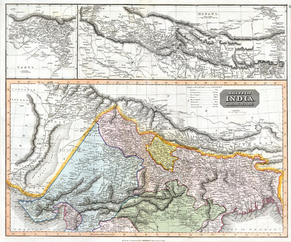
1817 Thomson Map of India with Nepal (set of 2 maps)
1817 (dated) $400.00
1814 Thomson Map of Northern India and Nepal
IndiaNepal-t-1814$200.00

Title
British India, Northern Part.
1814 20 x 25 in (50.8 x 63.5 cm)
1814 20 x 25 in (50.8 x 63.5 cm)
Description
This fascinating hand colored 1814 map by Edinburgh cartographer John Thomson depicts northern India and Nepal. Bounded on the east by Persia and the Indus valley, on the North by Tibet, on the south by Berar, and on the east by Assam and Bhutan. Much of the upper portion of this map includes a detailed inset of the Kingdom of Nepal or Nepaul. This area is depicted in impressive detail considering that, when this map was printed very few western travelers had ever been to Nepal. Includes roads, mountain passes and the residences of important Lamas. Extends fully into the Tibetan plateau as far as Te Shoo Loomboo and the Road to Lhasa (Lassa). The right hand corner of this map contains an inset of Kabul or Cabul.
Cartographer
John Thomson (1777 - c. 1841) was a Scottish cartographer, publisher, and bookbinder active in Edinburgh during the early part of the 19th century. Thomson apprenticed under Edinburgh bookbinder Robert Alison. After his apprenticeship, he briefly went into business with Abraham Thomson. Later, the two parted ways, John Thomson segueing into maps and Abraham Thomson taking over the bookbinding portion of the business. Thomson is generally one of the leading publishers in the Edinburgh school of cartography, which flourished from roughly 1800 to 1830. Thomson and his contemporaries (Pinkerton and Cary) redefined European cartography by abandoning typical 18th-century decorative elements such as elaborate title cartouches and fantastic beasts in favor of detail and accuracy. Thomson's principle works include Thomson's New General Atlas, published from 1814 to 1821, the New Classical and Historical Atlas of 1829, and his 1830 Atlas of Scotland. The Atlas of Scotland, a work of groundbreaking detail and dedication, would eventually bankrupt the Thomson firm in 1830, at which time their plates were sequestered by the court. The firm partially recovered in the subsequent year, allowing Thomson to reclaim his printing plates in 1831, but filed again for bankruptcy in 1835, at which time most of his printing plates were sold to A. K. Johnston and Company. There is some suggestion that he continued to work as a bookbinder until 1841. Today, Thomson maps are becoming increasingly rare as they are highly admired for their impressive size, vivid hand coloration, and superb detail. More by this mapmaker...
Condition
Fine or Perfect condition. Wide clean margins. Original platemark visible. Blank on verso.