
1700 Pierre Mortier Nautical Map of the Indian Ocean

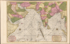
Carte Particuliere d'une Partie d'Asie ou sont Les Isles D'Andemaon, Ceylan, Les Maldives.../ Partie Occidentale d'une D'Asie ou sont les Isles De Zocotora De l'Amirante...
Superb Original Color.
- Digital Map Information
- Suitable for large format printing
- Full resolution TIFF file
- ICC color profile embedded
- Delivered instantly via download link
Superb Original Color.
This is a premium full-original-color example of Pierre Mortier's 1700 nautical chart and map of the Indian Ocean and the adjacent parts of eastern Africa, Arabia, Persia, India, and the Malay Peninsula. Countless islands are mapped, including the Maldives, Sri Lanka, and Sumatra.A Closer Look
The center of the map is dominated by the Mughal Empire, and many kingdoms of southern India are distinguished. To the east lie the Kingdoms of Siam, Mataban, Pegu, and Tibet. The western portion foregrounds the Persian Safavid Empire. In the Arabian Peninsula, Arabia (Arabie Heureuse) and Yemen (Grand Jaman) are recognizable. Mecca, Medina, and other key cities are also shown. The work's elegant engraving artfully balances the inland detail with rhumb lines and compass roses in the water areas. Inland topographical features are indicated pictorially.A Last Hurrah
The 17th century was characterized by Dutch domination of these waters, the East India Company having wrested control from the Portuguese in the first part of the century. By 1700, the Dutch hegemony in Asia was increasingly challenged by the English, French, and even the Danish. Over the course of the 18th century, India, in particular, fell within the English sphere of influence. Consequently, future advances in mapping and charting these regions were made by English and French hydrographers.Publication History and Census
This map was engraved by Pierre Mortier in 1700 for inclusion in hisNeptune François. As indicated by the presence of two separate cartouches, the two sheets could also be had as separate works; however, in Mortier's mammoth Neptune François they were frequently bound joined, as here. The map is well represented institutionally and appears occasionally on the market; examples of this quality and color are nonetheless extremely difficult to find.Cartographer
Pierre Mortier (January 26, 1661 - February 18, 1711) or Pieter Mortier was a cartographer, engraver, and print seller active in Amsterdam during the later 17th and early 18th centuries. Mortier, then known as Pieter, was born in Leiden. He relocated to Paris from 1681 to 1685, adopting the French name Pierre, which he retained throughout his career. While in France, he developed deep French connections by bringing sophisticated Dutch printing technology and experience to nascent French map publishers such as Guillaume De L'Isle (1675 - 1726), Alexis-Hubert Jaillot (c. 1632 - 1712), and Nicholas de Fer (1646 - 1720). Consequently, much of Mortier's business was built upon issuing embellished high quality editions of contemporary French maps - generally with the permissions of their original authors. In the greater context of global cartography, this was a significant advantage as most Dutch map publishes had, at this point, fallen into the miasma of reprinting their own outdated works. By contrast, the cartographers of France were producing the most accurate and up to date charts anywhere. Mortier's cartographic work culminated in the magnificent nautical atlas, Le Neptune Francois. He was awarded the Privilege, an early form of copyright, in 1690. Upon Pierre's death in 1711 this business was inherited by his widow. In 1721, his son Cornelius Mortier took over the day to day operation of the firm. Cornelius partnered with his brother-in-law Jean Covens to form one of history's great cartographic partnerships - Covens and Mortier - which continued to publish maps and atlases until about 1866. Further Details...
Source
Mortier, P., Suite de Neptune François, ou atlas nouveau des cartes marines, (Amsterdam: P. Mortier) 1700.
Condition
Excellent. Full margins and original outline and wash color.
References
OCLC 1028536685. Tibbetts, G. R., Arabia in Early Maps #164.