This item has been sold, but you can get on the Waitlist to be notified if another example becomes available, or purchase a digital scan.
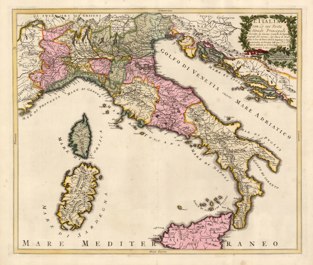
1701 Cantelli / Schenk Map of Italy Showing the Post Roads
Italy-schenk-1701$750.00

Title
L'Italia con Le sue Poste e Strade Principali descritta da Giacomo Cantelli da Vignola Geografo del Serenis. Sigr. Duca di Moda. Data in luce d Pietro Schenk Intagliator in Rame in Amsterdam con Privilegio delli miei Seci: S le Seci: S: Stati di Hollanda et di West Frisia, il primo di Settembre 'l Anno 1701.
1701 (dated) 19 x 22.25 in (48.26 x 56.515 cm) 1 : 2900000
1701 (dated) 19 x 22.25 in (48.26 x 56.515 cm) 1 : 2900000
Description
This is a beautiful example of a scarce, 1701 Peter Schenk map of Italy, focusing specifically on the country's post roads. It is derived from, and credits, the similarly-titled 1695 map produced by the Italian mapmaker Giacomo Cantelli da Vignola. Cantelli's map, printed in the year of that mapmaker's death, was the first significantly updated map of Italy to appear since Magini's 1608 Italia Nuova, which provided the basis for most maps of Italy issued in 17th and early 18th centuries.
This Schenk map has no dedication but it is curious that its title is not only in Italian, but is identical to that of its Italian source. Not only that, but the cartouche with its woven laurel border and its trio of scales is copied directly from the Cantelli. The original author, too, is credited directly in the title of the map - an honor seldom given to Magini, whose monumental map governed the mapping of Italy in the seventeenth century. The importance of Cantelli's contribution, then, cannot be overestimated. Just as Magini's map was copied throughout the 17th century, so Cantelli's was in the first part of the 18th. Not only this Schenk but also maps by Halma, Herman Moll, and Seutter faithfully copied the Cantelli. We have also seen maps on the Magini model - notably Frederic De Wit's 1680 map - in later Covens and Mortier editions amended to include the roads displayed on the Cantelli (without correcting the mountain ranges). Well into the 18th century, we see Cantelli's placement of the roads (with additions) on the Robert de Vaugondy Carte de l'Italie dans laquelle sent traceés les Routes des Postes.
Detailing the Post Roads of Italy
This map copies the rare, Cantelli da Vignola map of the same title published in 1695 by De Rossi in Rome. Cantelli, as did all mapmakers since 1608, used Magini's Italia Nuova as a foundation (although he omitted the ubiquitous, imaginary island-mountain of M. Sardo that characterized most Italy maps of the century). He diverged more sharply from that model in the selection and placing of cities and the depiction of mountain ranges and rivers. These changes were all in the service of highlighting the system of post roads connecting Italy's major cities, and then connecting Italy to the broader network of post roads in the greater the Holy Roman Empire. Mountains are shown, as in the Magini, pictorially. However, they are placed in such a way as to complement and to some extent explain the placement of the roads, illustrating important passes and the cities straddling them.Distinguished Dedication
Perhaps the occasion for this new map and its high level of specificity is hinted at in the dedication on Cantelli's map. It is dedicated to Michele de Tassis, the Marquis de Paul. The Marquis was 'Courier Maior,' the hereditary Head Postmaster in Rome (assigned to the family in 1619 by Philip III of Spain, who was also Philip II, King of Portugal, Naples, Sicily and Sardinia and Duke of Milan.)This Schenk map has no dedication but it is curious that its title is not only in Italian, but is identical to that of its Italian source. Not only that, but the cartouche with its woven laurel border and its trio of scales is copied directly from the Cantelli. The original author, too, is credited directly in the title of the map - an honor seldom given to Magini, whose monumental map governed the mapping of Italy in the seventeenth century. The importance of Cantelli's contribution, then, cannot be overestimated. Just as Magini's map was copied throughout the 17th century, so Cantelli's was in the first part of the 18th. Not only this Schenk but also maps by Halma, Herman Moll, and Seutter faithfully copied the Cantelli. We have also seen maps on the Magini model - notably Frederic De Wit's 1680 map - in later Covens and Mortier editions amended to include the roads displayed on the Cantelli (without correcting the mountain ranges). Well into the 18th century, we see Cantelli's placement of the roads (with additions) on the Robert de Vaugondy Carte de l'Italie dans laquelle sent traceés les Routes des Postes.
Publication History and Census
This map was engraved by Peter Schenk for inclusion in that mapmaker's Atlas Contractus, as early as 1698. There are perhaps a dozen examples of this separate map in institutional collections.CartographerS
Petrus Schenk (Pieter Schenck) the Elder (December 26, 1660 - 1711) was a Dutch engraver, globe maker, and map publisher active in Amsterdam and Leipzig in the latter half of the 17th century. Schenk, was born in Elberfield, Germany. He moved in Amsterdam in 1675, becoming the apprentice to Gerard Valk (Valck). In 1687, Schenk married Agatha Valk, Gerard Valk's sister and went into partnership with his brother-in-law under the imprint of 'Valk and Schenk'. Initially they focused on maps and atlases, acquiring the map plates of Jan Jansson and Jodocus Hondius in 1694. Later, in 1701 they moved into the former Hondius offices where they began producing globes. Valk and Schenk quickly became known for producing the best globes in the Netherlands, a business on which they held a near monopoly for nearly 50 years. Schenk's three sons, Pieter Schenk the Younger, Jan Schenk, and Leonard Schenk, all became engravers in their own right. Pieter Schenk the Younger inherited the business and ran his father's shop in Leipzig. His daughter, Maria Schenk, married Leonard Valk, the son of Gerard Valk, and continued to run the Valk and Schenk map engraving workshop in Amsterdam. More by this mapmaker...
Giacomo Cantelli da Vignola (February 22, 1643 - November 30, 1695) was an important Italian cartographer and engraver active in 17th century Italy. Cantelli was born in Montorsello, near Vignola, Italy to a prominent local family. After studying literature at the University of Bologna, Cantelli took a position as secretary to the Marquis Obizzi de Ferrara. Eventually Cantelli relocated to Venice where he developed an interest in cartography. He later traveled to Paris in the company of the French ambassador where became acquainted with the French cartographer Guillaume Sanson, as well as his contemporaries Jacques-Andre Duval and Michel-Antoin Baudrand. It was most likely the influence of these innovative French cartographers that inspired Cantelli's careful and meticulous approach, in which he based his cartography not just on earlier maps, but also very much in the French style upon accounts written by travelers and merchants regarding actual travel to foreign lands. Back in Italy, Cantelli took service with Count Rinieri Marescotti, with whom he traveled extensively throughout Italy, becoming in the process acquainted with the Italian publisher Giovanni Giacomo de Rossi. It is with Rossi that Cantelli began officially publishing his maps. The earliest maps to bear the Cantelli-Rossi imprint date to 1672 and detail the Holy Land, Persia, and the Ottoman Empire. Around 1680 the duo also began to publish the Mercurio Geografico, a large format atlas illustrating all parts of the world in a splendid Italian baroque detail defined by elaborate finely engraved cartouche work, high quality paper, bold Roman lettering, and dark rich inks. Some have compared his style go that of Giovanni Antonio Magini, another Italian cartographer of the previous generation. Cantelli da Vignola in fact pioneered the Italian style of fine bold engraving that would eventually be embraced and expanded upon by Vincenzo Coronelli. His work drew the attention of Pope Innocent XI and Reggio Francesco II d'Este, the Duke of Modena, both of whom offered him a position as court geographer. Cantelli chose to work with the Duke of Modena, in the service of whom he produced numerous maps and well as two large globes. He died in Modena in November 1695. Learn More...
Giovanni Antonio Magini (June 13, 1555 - February 11, 1617) was an Italian astronomer, astrologer, cartographer, and mathematician. Born in Padua, he completed his studies in philosophy in Bologna in 1579. In 1588 he was chosen over Galileo Galilei as the chair of mathematics at the University of Bologna after the death of Egnatio Danti. Magini was a prolific writer, putting forth theories of celestial motion (he was a supporter of a geocentric solar system), the use of quadrants in surveying and astronomy, and trigonometry. In 1608, Magini produced the first map of Italy to improve on that of Gastaldi: his meticulously researched and beautifully engraved 8-sheet Italia Nuova was hugely influential: upon its publication, Blaeu promptly copied it to produce his own wall map of Italy; the rest of the mapmaking establishment swiftly followed suit. Consequently, virtually every 17th century map of Italy can be identified as a derivative of Magini's monumental achievement. His atlas, Atlante geografico d’Italia, was published posthumously by his son in 1620. This work was intended to include maps of every Italian region with exact nomenclature and historical notes. He also served as court astrologer for the Duke of Mantua. Learn More...
Source
Schenk, P., Atlas Contractus, (Amsterdam) 1701.
Condition
Excellent. A superb example with a bold strike in lush original color. Reinforced marginal split at bottom centerfold, else fine.
References
OCLC 931899541.