
1786 / 1799 Dépôt de la Marine Jamaica (Slave Rebellion Content)

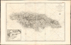
Carte de l'Ile de la Jamaique, extraite des Cartes topographiques Anglaises de T. Craskell... et de J. Simpson. Rédigée en 1786, corrigée et augmentée en 1799.
Jamaica During the Maroon Wars.
- Digital Map Information
- Suitable for large format printing
- Full resolution TIFF file
- ICC color profile embedded
- Delivered instantly via download link
Jamaica During the Maroon Wars.
This is a rare, large-format 1799 chart and map of Jamaica with an inset of Kingston Harbor. Issued in the wake of the Second Maroon War (1795), and overshadowed by the imminent French loss of Haiti to Toussaint Louverture, this map represents an effort by the French to absorb and utilize the best British information pertinent to Jamaica during a period in which both the British and the French were experiencing slave rebellion in the West Indies. Despite decades of war with each other, the Caribbean territories of these two slave-holding empires found common ground in the face of their respective revolts. British forces fought in Haiti in support of French planters until 1798; it may be that this work was produced in anticipation of returning the favor.A Closer Look
Based on the 1763 Craskell-Simpson map of Jamaica, this map was compiled by the French Dépôt de la Marine in 1786, but remained unpublished until 1799. This work bears characteristics of both a chart and a map. Its rhumb lines and depth soundings reflect its nautical utility, particularly with the detailed inset chart of Kingston Harbor at the lower left. Rather than adhering to the coastline, it presents the interior of the island in detail. Rivers and major settlements are marked, with particular attention to roads and rivers.The topography of the island is represented accurately: not just mountains, but also wetlands, particularly in the western part of the island. The map's general outline and interior details derive from the 1763 Craskell-Simpson map. Although that earlier work names Jamaica's mountain ranges, it does not depict them graphically. One might therefore assume that the Dépôt cartographers added mountains wherever the British map identified them by name. However, the present map also portrays mountainous terrain - notably at Hellshire - in areas the 1763 map does not describe as mountainous, indicating that the cartographers relied on additional sources or interpretation.Decades of Rebellion
The 1763 Craskell-Simpson map was produced as a response to Tacky's Rebellion (April 1760 - October 1761) and the present work represents a record of British efforts to control the Maroon settlements of Jamaica's highlands, by treaty or eradication. In the eastern county of Surry, for example, the Windward Maroon settlements of Old Crawford Town and Old Nanny Town are marked 'abandoned;' the latter was actually destroyed by the British in 1734 during the First Maroon War; Crawford's Town was destroyed following its revolt in 1754, with some of its Maroons resettling in Charles Town (New Crawford Town on the map) and some in Scott's Hall (Negroe Town on the map). The Maroons of these new settlements would prove instrumental in the ending of Tacky's Rebellion, Tacky himself being killed by a Scott's Hall Maroon.In the highlands of the parishes of St. James and St. Elizabeth. The Leeward Maroon settlements of Trelawny Town and Accompongs Town formed the center of the Second Maroon War, and indeed the towns would oppose each other, with the Maroons of Accompongs Town supporting the British in the conflict. The results of the war are not recorded in this work, which was drafted nearly ten years prior. Still, the occurrence of that rebellion against the backdrop of the Haitian uprising provided the context for the Dépôt to have finally committed this chart to print.
The Compilation
That the Dépôt chart owes its greatest debt to the 1763 Craskell-Simpson is plainest in the placement and naming of Jamaica's settlements, both British and Maroon; while it does not name every plantation (as the source map quite nearly did), it does mark the position of a great many, and these correspond closely to the 1763 source. The windmills, marking sugar mills mainly along the northern coast, and the anchorages surrounding the island are also sourced from the Craskell-Simpson.The island's topography, which is not pictured on the 1763 map, represents a significant improvement, and one whose source is not apparent. While pictorial, it is much more representative of the island's topography than on any prior map. While the Craskell-Simpson had depicted marshlands visually, it had only named mountain areas without picturing them; some areas (such as the dunes of Hellshire) were left blank. So while some of the fine detail of the 1763 map relevant specifically to British landholders and military authorities does not appear here, the present work is far more communicative to the outsider of the difficulty faced by the British in controlling Jamaica's mountainous interior in the face of an established guerrilla insurgency.
The inclusion of a chart of Kingston Harbor is new and noteworthy. It is a faithful reduction of J.F.W. DesBarres' A chart of Port Royal and Kingston Harbours in the island of Jamaica, and represents the most up-to-date identifiable element of the chart: the DesBarres chart was published in 1781 as part of his Atlantic Neptune, the chief nautical atlas of the British Navy during the American Revolution. If the French had been in a position to aid their British fellow plantation owners, that aid would have passed through Kingston Harbor, and the inclusion of this chart would therefore be desirable and relevant.
Publication History and Census
This chart was compiled by the Dépôt de la Marine in 1786, but we see no example in any form that was published any earlier than 1799. These were printed for inclusion in the Dépôt's Hydrographie Française, appearing in examples well into the 19th century (see Rumsey's example of the Hydrographie, dated 1833). All examples we see in OCLC that have been assigned the date of 1786 also include the text 'Corrigeé et Augmenteé en l'An VIII de la République' a date in the French Republican calendar corresponding to a Gregorian date of 1799. Such examples also exhibit plate number 71 in the upper right corner. Following the abolishment of the new calendar by Napoleon in January 1806, the date of the map was amended to read 'Corrigeé et Augmenteé en 1799.' No other changes to the chart were instituted apart from the plate number, altered to 181. We see three examples of the first, 'Republican' state of the chart in institutional collections. We only see one separate example of the chart with the '1799' correction in the Staatsbibliothek zu Berlin, but this state has appeared on the market from time to time.Cartographers
Dépôt des Cartes et Plans de la Marine (fl. 1720 - present), often called the Dépôt Général de la Marine, was a French hydrographic mapping organization founded in 1720 under Charles-Hercule of Albert de Luynes (1674 - 1734). Much like the U.S. Coast Survey, the British Admiralty, and the Spanish Deposito Hydrografico, the Dépôt was initiated as a storehouse and distribution center of existing nautical and marine charts. Eventually the Dépôt initiated its own mapping activities in an attempt to improve and expand upon existing material. Some of the more prominent cartographers and hydrographers associated with the of Dépôt Générale des Cartes were, Philippe Buache, Jacques-Nicholas Bellin, Giovanni Rizzi-Zannoni, Rigobert Bonne, and Jean Nicolas Buache. Further Details...
Thomas Craskell (17xx - May 1790) was a British civil engineer, architect, and artist based in Jamaica in the mid-18th century. Little is known of his youth, education, or even birth date, though this was likely about 1720. He first appears as a lieutenant in the Engineer Corps accompanying Major-General Peregrine Hopson (1696 - 1759) in the 1759 British invasions of Martinique and Guadeloupe. He later became the Chief Engineer of Jamaica. As an architect, he designed the neoclassical governor's mansion 'King's House' (1762), located in Spanish Town, Jamaica. Craskell was also an accomplished maritime painter in the mid-19th-century school of Peter Monamy (1681 - 17549) and Samuel Scott (c. 1702 - 1772), both of whom he considered friends. His precise rendering of sails and rigging suggests a deep knowledge of maritime engineering. Only four known paintings by Craskell survive. His cartographic output is limited to three large-format maps of Jamaica, completed with James Simpson, and published in 1763. His son, also Thomas Craskell, was appointed Superintendent General of the Maroons of Trelawny Town to replace Major John James. Further Details...
James Simpson (fl. c. 1755 - 1770) was a British civil engineer and surveyor based in Jamaica and the wider British West Indies in the mid-18th century, a period marked by significant land acquisition, plantation expansion, and strategic mapping efforts under British rule. Details about his life are highly elusive. In the late 1750s, to at least 1761, he served as Chief Surveyor in Jamaica. By 1765, we find him in Dominica, where he produced a survey of Portsmouth, Charlotte-Town (Charlotte-Ville); then St. Vincent, where he surveyed Kingston; then Tobago, where he mapped Georgetown. Most of the surveys went unpublished and survive only in manuscript form. Further Details...
Joseph Frederick Wallet Des Barres (November 22, 1721 - October 24, 1824) was a Swiss-British hydrographer active with the Royal Navy in the second half of the 18th century. Des Barres was born in Switzerland. He attended the University of Basel, where he tutored under the great mathematician Daniel Bernoulli. Following his studies in Basel, Des Barres immigrated to Great Britain, where he continued his education at the Royal Military College of Woolwich. Sometime in the 1850s, Des Barres joined the American Regiment of the Royal Army as a military engineer. He was assigned to the team surveying the St. Lawrence River, where he worked with the legendary cartographer Samuel Holland and the young James Cook. Afterward, Des Barres surveyed and mapped the Maritime Provinces of New Brunswick, Nova Scotia, and Newfoundland. Des Barres's work is known for its stunning combination of accuracy and aesthetic appeal. Augustyn, in Manhattan in Maps, writes that with Des Barres, "nautical charting took an unprecedented leap toward greater precision and graphic sophistication". Upon his return to England in 1774, Des Barres was assigned to compile all of the most current cartographic information on the New World into the seminal Atlantic Neptune, which has been described as the "most splendid collection of charts, plates and views ever published" (National Maritime Museum Catalogue). Des Barres eventually returned to Canada, where he lived another 40 years as a wealthy landowner and active political figure. He died at the ripe old age of 103, one of the few centenarians of the early 19th century. Further Details...
Source
Dépôt de la Marine, Hydrographie Francoise, (Paris: Dépôt des Cartes et Plans de la Marine) 1806
Condition
Excellent, with generous margins.
References
OCLC 557809408. Rumsey 15934.382.