
1903 Thacker Map of Jammu and Kashmir, India

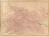
The Territories of the Maharaja of Jummoo and Kashmir with Portions of the Adjoining Countries.
Plague in Kashmir, November 1903.
- Digital Map Information
- Suitable for large format printing
- Full resolution TIFF file
- ICC color profile embedded
- Delivered instantly via download link
Plague in Kashmir, November 1903.
This is a separately issued 1903 'Thacker and Spink' and Edward Stanford map of the Jammu and Kashmir region in modern-day India and Pakistan, likely published in reaction to news of a plague outbreak in Kashmir. Though initially published for Duke's Guide to Kashmir, this is a separately-issued example.A Closer Look
The map depicts Jammu and Kashmir from Rawalpindi to Chinese Tibet and from Yarkand (modern-day western China) to Gujarat and Ramnagar.As the 'Jewel of the British Empire,' news from India arrived in Britain with relative speed. Edward Stanford, who published this map, built a business by quickly issuing maps, sometimes quickly-updated reissues of older maps, relating to current news events, hence this map, published in the wake of a regional plague outbreak.
The 1903 Plague Outbreak in Kashmir
Although provinces surrounding Kashmir suffered plague outbreaks from 1901 - 1903, the disease had, until November 1903, mostly avoided Kashmir itself. Government officials traced the outbreak in Kashmir to two servants traveling from an infected region. The individuals were said to have been asymptomatic when they arrived, but died within a week of entering Kashmir. Many refused to believe the plague had come to Kashmir. In a report concerning the outbreak, the official remarked,In the carrying out of plague measures, no help of any kind was received either from the people or their leaders. Everything was done through official agencies. No heed was paid to the clamour of the people and measures which were thought right and suitable were carried out with a firm hand.
Publication History and Census
This map was created by Thacker, Spink, and Company and published by Edward Stanford in 1903. Scarce. Just three examples are cataloged in OCLC and are part of the institutional collections at the University of Michigan, Texas A and M University, and the National Library of Australia.Cartographers
Thacker, Spink, and Company (c. 1863 - 1960) was a publishing company based in Calcutta and was the Indian office of Thacker and Company, which was based in London. They published Thacker's Bengal Directory from 1864 until 1884, which included parts of present-day Myanmar and Bangladesh. The directory was renamed Thacker's Indian Directory in 1885 and covered all of British India. They also published picture postcards Further Details...
Edward Stanford (May 27, 1827 - November 3, 1904) was one of the most prolific map publishing firms of the late 19th century. The company began as a partnership in 1848 between the 21 year old Edward Stanford and the established map dealer Trelawney Saunders. By 1853 the partnership had dissolved and Edward Stanford took full control of the business. A subsequent series of expansions and exciting new map issues finally led to the production of Stanford's masterwork, "Stanford's Library Map of London". This map is still available and remains somewhat accurate. At the time of publishing it was hailed by the Royal Geographical Society as "the most perfect map of London that has ever been issued". In 1882 Edward Stanford Sr. passed the firm on to his son, Edward Stanford Jr. who continued in his father's proud tradition. Today the Stanford firm still publishes maps and remains one of the most important and prolific cartographic publishers in the world. Further Details...
Condition
Very good. Dissected and mounted on linen in eighteen (18) panels. Verso reinforcement to one linen fold line. Blank on verso.
References
OCLC 76700190.