This item has been sold, but you can get on the Waitlist to be notified if another example becomes available, or purchase a digital scan.
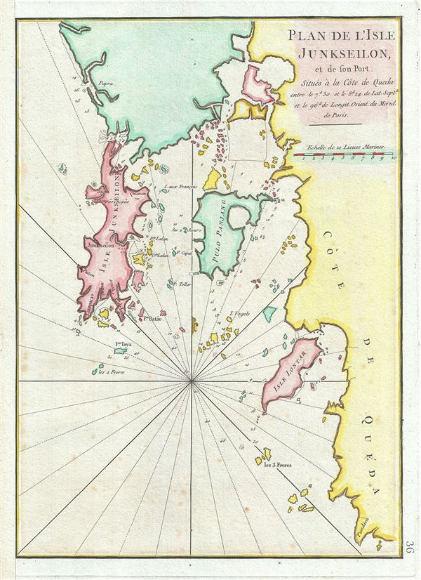
1775 Mannevillette Map of the Island and Port of Junkseilon or Phuket, Thailand
Junkseilon-mannevillette-1775$125.00

Title
Plan de l'Isle Junseilon, et de son Port.
1775 (undated) 14 x 10 in (35.56 x 25.4 cm) 1 : 400000
1775 (undated) 14 x 10 in (35.56 x 25.4 cm) 1 : 400000
Description
This is a scarce 1775 nautical chart or maritime map of the port and harbor of the Island of Phuket, Thailand by Jean-Baptiste d'Apres de Mannevillette. It details the Island of Phuket or Junk Ceylon along with its harbors and the coast of Queda (Kedah). One of the earlier maps to show Phuket in detail. Today Phuket is one of the most visited islands in the world a major center of Thai tourism. In the 18th century Phuket was located on one of the important trading arteries between India and China, as well as being itself a rich source of tin and rubber.
The basic cartography of this map dates to Mannevillette's voyages as pilot for the Compagnie des Indies in the early 1700s. It was originally published in Paris in 1745. This may well be the 1745 edition, but it is unclear as no major changes seem to have been made between the first and second editions. In any case it was republished in 1775 in an expanded second edition of the Neptune Oriental.
The map offers impressive detail including depth soundings, commentary on reefs, rhumb lines, shoals, place names and a wealth of other practical information for the mariner. This chart was drawn by Jean-Baptiste d'Apres de Mannevillette and engraved by Guillaume-Nicolas Delahaye for publication in the 1775 Neptune Oriental
CartographerS
Jean-Baptiste Nicolas Denis d'Après de Mannevillette (February 11, 1707 - March 1, 1780) was a French sailor, navigator, and hydrographer active in the mid-18th century. Mannevillette was born in Le Havre to a family of wealthy seafarers. He completed his first major voyage at 12, when he accompanied his father, Jean-Baptiste-Claude d'Après de Blangy, a captain of the Compagnie des Indes (French East India Company) vessel Solide to Bengal. On his return to France, he he studied mathematics and navigation in Paris under Joseph Nicholas De L'Isle (1688 - 1768) before returning to the sea at 19 as a fourth officer as on the merchant vessel Marechel d'Estrees. Mannevillette himself eventually attained the rank of Captain with the Compagnie des Indes. In the course of numerous voyages around Africa to India and China, Mannevillette collected and revised numerous nautical charts. His sophisticated use of the most modern instruments, most specifically the Octant or English Quarter, and keen mathematical mind, enabled Mannevillette to correct many significant errors common to earlier maps. These updates were eventually compiled and published in Mannevillette's most significant work, the 1745 Le Neptune Oriental. The 1745 Neptune Oriental was commissioned by the Compagnie des Indes and its production earned Mannevillette admission into the Academy of Sciences. The atlas was well received, but shortly after publication, most unsold examples were destroyed by the French Admiralty, who considered the secrets of East Indian navigation too dangerous for dissemination. In 1762 the Compagnie des Indes appointed Mannevillette director of chart at Lorient. In 1767 King Louis XV conferred the Order of St. Michael upon him and made him an associate of the Royal Marine Academy. In the 30 years following his first publication of Le Neptune Oriental, Mannevillette worked doggedly with his lifelong friend, Alexander Dalrymple (1737 - 1808) to update his original work with new and improved charts. In 1775, he republished his opus in a greatly expanded format - by this time nautical information was less tightly guarded. Mannevillette died on March 1, 1780 at 75 years of age. More by this mapmaker...
Guillaume-Nicolas Delahaye (1725 - February 24, 1802) was the most prolific member of the Delahaye (De-La-Haye) family of engravers active in Paris throughout the 18th century. Given that the name, Delahaye literally translates to 'of the Hague' it can be assume they were French Huguenots who were forced to flee the Netherlands under threat of religious persecution. Born in Paris, he was the son of patriarch Jean-Baptiste Delahaye and brother to Jean-Baptistie-Henri Delahaye. It is said that his godfather, who held him at the baptismal font, was none other than the famous french cartographer Guillaume de L'Isle. The Delahaye family engraved for many of the great cartographers of 18th century Paris, including Jean-Baptiste Bourguignon d'Anville, Didier Robert de Vaugondy, Jean-Baptiste de Mannevillette, and Jean-Nicolas Buache, among others. He was awarded the public office Premier Graveur du Roi and worked on a series of maps illustrating the king's hunts around Versailles. Guillaume also worked with foreign cartographers such as Tomas Lopez of Madrid. Possibly Delahaye's most significant map is A Map of the Country between Albemarle Sound and Lake Erie prepared for the memories of Thomas Jefferson. He married in 1758. In total he engraved some 1200 maps. Delahaye died in Charenton. In 1792, his daughter, Antoinette Marie Delahaye (1773-1857), married the geographer Jean-Denis Barbie du Bocage. Learn More...
Source
Mannevillette, Jean-Baptiste d'Apres de, Le Neptune Oriental, (Paris) 1775.
Condition
Very good. Original platemark visible. Left margin extended.