This item has been sold, but you can get on the Waitlist to be notified if another example becomes available, or purchase a digital scan.
1910 U.S.C.G.S. Nautical Chart / Map of the Kennebec and Sheepscot Rivers, Maine
KennebecSheepscot-uscgs-1910$325.00

Title
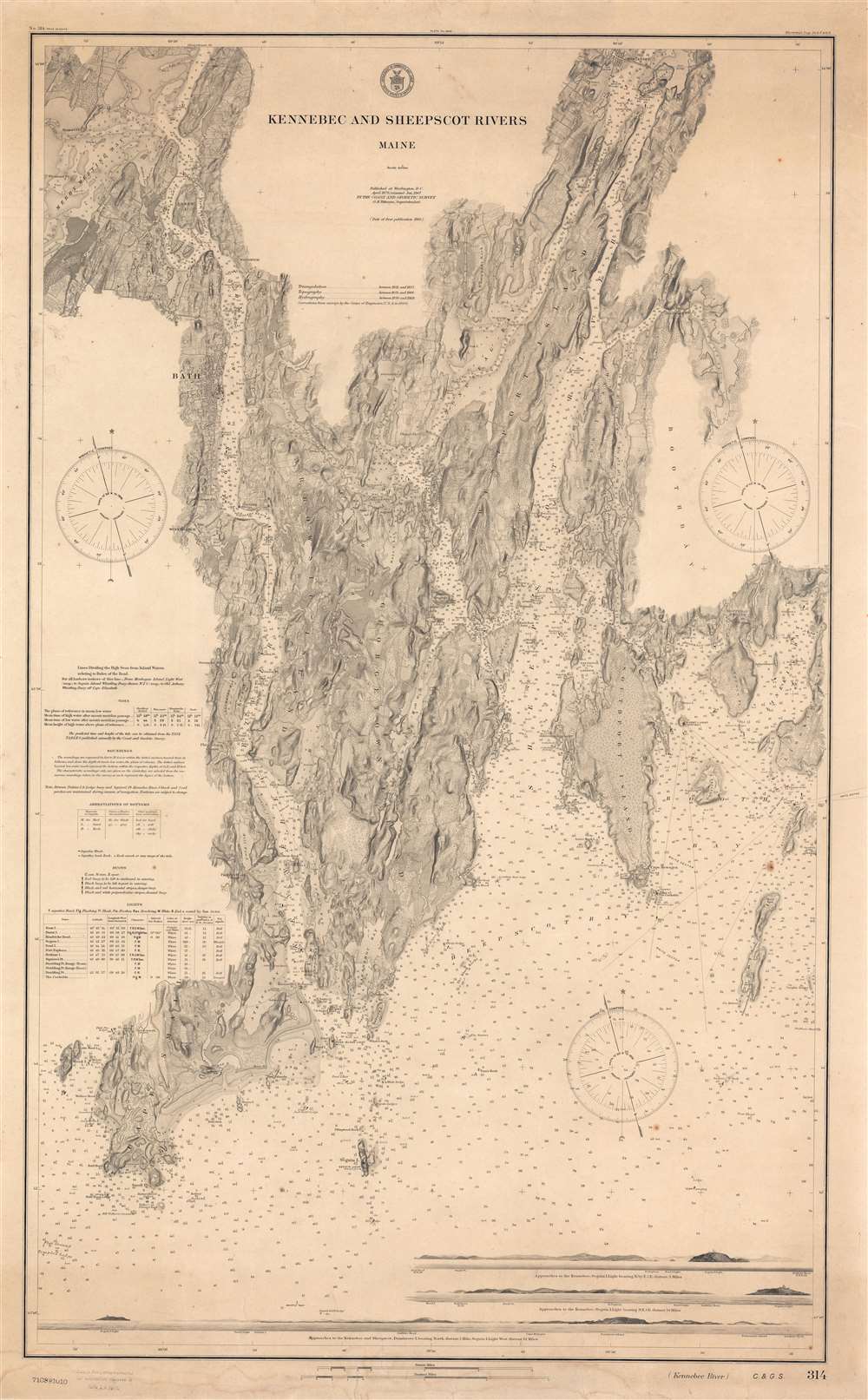
Kennebec and Sheepscot Rivers Maine.
1910 (dated) 40.25 x 25 in (102.235 x 63.5 cm) 1 : 40000
1910 (dated) 40.25 x 25 in (102.235 x 63.5 cm) 1 : 40000
Description
A striking 1910 nautical chart or maritime map of the Kennebec and Sheepscot Rivers, Maine. Representing the culmination of the Coast and Geodetic Survey's work in the region, coverage extends from Cape Small and the mouths of both rivers, north as far as Wiscasset (considered one of Maine's most beautiful small towns). Named towns include Bath, a regional shipbuilding center, and the fishing port of Boothbay Harbor. Along the bottom there are three land profiles offering different views of Seguin Light. Countless depth sounding and practical information for the mariner fill the waters. This is a separate issue nautical chart, intended for maritime use, and is thus considerably more developed than earlier folding examples of the chart issued for the Survey's annual reports.
Publication History and Census
This chart was first issued in 1868. It inherits its general form from earlier charts issued in the 1850s and 1860s by the U.S. Coast Survey, but is much expanded with exceptional geodetic detail inland. The present example was reissued under the supervision of Otto Hilgard Tittmann, Superintendent of the Survey. It bears major updates to 1909, and minor updates to 1910. Uncommon thus.CartographerS
The Office of the Coast Survey (1807 - present) founded in 1807 by President Thomas Jefferson and Secretary of Commerce Albert Gallatin, is the oldest scientific organization in the U.S. Federal Government. Jefferson created the "Survey of the Coast," as it was then called, in response to a need for accurate navigational charts of the new nation's coasts and harbors. The spirit of the Coast Survey was defined by its first two superintendents. The first superintendent of the Coast Survey was Swiss immigrant and West Point mathematics professor Ferdinand Hassler. Under the direction of Hassler, from 1816 to 1843, the ideological and scientific foundations for the Coast Survey were established. These included using the most advanced techniques and most sophisticated equipment as well as an unstinting attention to detail. Hassler devised a labor intensive triangulation system whereby the entire coast was divided into a series of enormous triangles. These were in turn subdivided into smaller triangulation units that were then individually surveyed. Employing this exacting technique on such a massive scale had never before been attempted. Consequently, Hassler and the Coast Survey under him developed a reputation for uncompromising dedication to the principles of accuracy and excellence. Unfortunately, despite being a masterful surveyor, Hassler was abrasive and politically unpopular, twice losing congressional funding for the Coast Survey. Nonetheless, Hassler led the Coast Survey until his death in 1843, at which time Alexander Dallas Bache, a great-grandson of Benjamin Franklin, took the helm. Bache was fully dedicated to the principles established by Hassler, but proved more politically astute and successfully lobbied Congress to liberally fund the endeavor. Under the leadership of A. D. Bache, the Coast Survey completed its most important work. Moreover, during his long tenure with the Coast Survey, from 1843 to 1865, Bache was a steadfast advocate of American science and navigation and in fact founded the American Academy of Sciences. Bache was succeeded by Benjamin Pierce who ran the Survey from 1867 to 1874. Pierce was in turn succeeded by Carlile Pollock Patterson who was Superintendent from 1874 to 1881. In 1878, under Patterson's superintendence, the U.S. Coast Survey was reorganized as the U.S. Coast and Geodetic Survey (C & GS) to accommodate topographic as well as nautical surveys. Today the Coast Survey is part of the National Oceanic and Atmospheric Administration or NOAA as the National Geodetic Survey. More by this mapmaker...
Otto Hilgard Tittmann (August 20, 1850 - August 21, 1938) was a German-American geodesist, geographer, and astronomer. Born in Belleville, Illinois, Tittmann attended school in St. Louis before joining the U.S. Coast and Geodetic Survey on November 10, 1867, and would remain with the U.S.C.G.S until his resignation 48 years later. Between 1889 and 1893, Dr. Tittmann was in charge of the Office of Standard Weights and Measures, which was, at this time in American history, part of the Coast and Geodetic Survey, and would remain so until the establishment of the National Bureau of Standards. During his time in charge of Weights and Measures, Tittman was sent to Paris to bring to the United States the national standard meter and to study weights and measures offices in Paris, London, and Berlin. Tittmann was named Assistant Superintendent of the Coast and Geodetic Survey on April 18, 1899 and was elevated to the post of Superintendent on December 1 1900, which he held until he resigned the post on April 15, 1915. Tittman, a co-founder of the National Geographic Society, served as the Society's President from 1915 until 1919. He was also a member of the Philosophical Society of Washington, the American Philosophical Society, the Washington Academy of Sciences, the American Association for the Advancement of Scient, the American Meteorological Society, the American Society of Civil Engineers, and the Cosmos Club. Dr. Tittman was a respected geodesist and renowned as one of the best in the country. Learn More...
Condition
Good. Some toning and soiling.