
1942 German-Polish Map of Krakau Subdistrict, Poland, World War II, w/ Manuscript Annotations

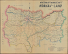

Kreishauptmannschaft Krakau-Land.
Administrative Map from the Nazi Occupation of Poland
$1,000.00
Choose a Collection:
- Digital Map Information
- Suitable for large format printing
- Full resolution TIFF file
- ICC color profile embedded
- Delivered instantly via download link
This Item
Enquire
Administrative Map from the Nazi Occupation of Poland
This is a c. 1942 German-Polish administrative map of Krakau-Land, the rural county surrounding Kraków during the Nazi occupation of Poland. Its emphasis on municipal boundaries, administrative offices, and graded roads presents the countryside as a network of jurisdictions and communications rather than a military battlefield. Particularly telling is the western boundary, labeled Deutsches Reich, which separates this county of the General Government from Polish territory annexed directly to Germany. Kraków itself was the capital of the occupation government, making the surrounding county part of its immediate administrative hinterland.A Closer Look
Drawn at 1:100,000, the map encompasses Kraków and the surrounding countryside, extending east through Bochnia and south through Myślenice, here labeled Myslenitz. Neighboring jurisdictions are identified around the perimeter as Miechow, Tarnow, Neu Sandez, and Neumarkt. Geographic detail stops largely at the county boundary, emphasizing the administrative territory rather than its wider geographical setting.The large German title and German-language legend establish the map's official vocabulary, while numerous smaller settlements retain Polish names. Kraków appears as a compact, separately outlined urban area near the northern center of the sheet. Broad pink, green, and blue bands make sections of the county's irregular perimeter immediately legible, while finer internal lines divide the countryside into smaller jurisdictions.
The legend distinguishes county and municipal boundaries, through roads, district roads, county roads, local roads, and railways. Blue, green, and yellow road lines stand out against the dense settlement names, allowing the principal connections between administrative centers to be followed without losing the underlying village geography. Separate symbols identify administrative outstations, permanent office days, collective municipalities, individual municipalities, and railway stations. The inclusion of office days is especially revealing: this was a geography of access to local administration as well as a map of territorial divisions.
The example is cataloged with manuscript annotations. Their authorship and date are unidentified, and no particular military operation or administrative action can securely be assigned to them.
Kraków and the Occupation Administration
The General Government came into operation on October 26, 1939, administering German-occupied Polish territory not directly annexed to the Reich. Kraków served simultaneously as its capital and as the seat of the larger Kraków District. The county represented here should therefore be distinguished from that much larger district. The map's western inscription records an occupation-imposed division within prewar Poland, not an internationally recognized Polish-German frontier.This administrative landscape was also the setting for forced labor, dispossession, and persecution. In 1940, German authorities expelled approximately 55,000 Jews from Kraków into the surrounding countryside; the following year, the remaining Jewish population was confined to a ghetto in the city's Podgórze district. These events provide essential context for the map, although neither its legend nor its identified annotations establishes a specific connection with those operations.
Publication History and Census
The map is undated and is assigned here to c. 1942. No maker or publisher is identified on the supplied image. A related map with the same title and scale bears a November 1942 date, but places its title and publication information at the lower right rather than the upper right, as here. That dated map establishes a contemporary parallel, not an exact edition match.The National Archives in Kraków records maps under this title in its cartographic collection, including reference 29/663/0/7/1198, dated approximately 1940, and 29/663/0/7/2360, assigned broadly to 1939 - 1945. These records document institutional holdings of occupation-period Krakau-Land maps, although an exact match to the present version has not been established.
Condition
Very good. Light wear along original fold lines. Closed margin tears professionally repaired on verso. Closed tear extending 1 inch within printed area professionally repaired on verso.
References
Archiwum Narodowe w Krakowie, 29/663/0/7/1198, 9/663/0/7/2360.