
1740 Chopy Map of Lake Geneva (Lac Leman) and Environs, France and Switzerland

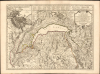

Carte du Lac de Genève et des Pays Circonvoisins...
Lovely Lake Geneva, with a city plan.
- Digital Map Information
- Suitable for large format printing
- DPI: 600
- File Size: 41.06 MB
- File Type: ZIP / TIFF
- ICC color profile embedded
- Delivered instantly via download link
Lovely Lake Geneva, with a city plan.
This beautiful engraving is Philippe Buache's 1740 map of Lake Geneva and environs, covering the northwestern end of the European Alpine region that today straddles the border between France and Switzerland.A Closer Look
The map encompasses the Republic of Geneva and neighboring borderlands of France, Switzerland, and Savoy. The region's mountainous terrain is evocatively pictured, with some important peaks named. Rivers are placed in sharp detail, as well as canals such as the Canal Stockalper on the left bank of the Rhône, dug between 1651 to move salt from Collombey to Bouveret on Lake Geneva. Cities, towns and villages are indicated; symbols designate those areas belonging to the Republic of Geneva and those belonging to France; Catholic and Protestant parishes are also differentiated. Forests and vineyards are shown pictorially. Key roads are clearly depicted.In the upper left is a richly-detailed plan of Geneva and its fortifications; a separate key for the plan dominates the top of the engraving and indicates fifty-eight locations on the plan.
Bigger not always Better
Buache's map is a 'reduced, corrected and augmented' edition of Antoine Chopy's map of the same title, published in 1730 to accompany the authoritative and comprehensive Histoire de Genève, rectifiée et augmentée par d'amples notes. Crepy's map, engraved by Daudet in Lyon, was a two-sheet map, approximately six inches wider than the present work. Working at this scale, however, was apparently necessitated by the limitations of the engraver. Buache's Paris shop was able to engrave the map's detail far more clearly and attractively than Daudet in a more manageable single-sheet format. The lettering is arranged more legibly; roads are more distinguishable as such. Along with the inclusion of the superb city plan, it is certainly in the engraver's realm that the map was 'rectified and augmented.'Publication History and Census
This map was drawn by Antoine Chopy and engraved by Jean-Louis Daudet in Lyon in 1730. This first state of the Paris edition, produced by Philippe Buache, was completed in 1740. A second state, updating the work to include changes due to the Treaty of Turin, was executed in 1760. The 1740 first state appears in only a handful of institutional collections; it is scarce on the market.Cartographers
Antoine Chopy (1674 - August 31, 1760) was born in Narbonne and later moved to Geneva, where he worked at the college (now university) there. He began training as an engraver, eventually becoming known for engraving maps and panoramic views of Geneva. Further Details...
Phillipe Buache (February 7, 1700 - January 24, 1773) was a late 18th-century French cartographer and map publisher. Buache began his cartographic career as the workshop assistant and apprentice to the important and prolific cartographer Guillaume de L'Isle (1685 - 1726). Upon De L'Isle's untimely death, Buache took over the publishing firm, cementing the relationship by marrying De L'Isle's daughter. Over the years, Buache republished many of De L'Isle's maps and charts. Buache was eventually appointed Premier Geographe du Roi, a position created for and previously held by Guillaume de L'Isle. Buache is most respected for introducing hachuring as a method for displaying underwater elevation on a two-dimensional map surface. Buache compiled maps based upon geographic knowledge, scholarly research, the journals of contemporary explorers and missionaries, and direct astronomical observation. Nevertheless, even in 18th-century Paris, geographical knowledge was severely limited - especially regarding those unexplored portions of the world, including the poles, the Pacific northwest of America, and the interior of Africa and South America. In these areas, Buache, like his primary rival Robert de Vaugondy (fl. c. 1716 - 1786), must be considered a speculative geographer or 'positive geographer'. Speculative geography was a genre of mapmaking that evolved in Europe, particularly Paris, in the middle to late 18th century. Cartographers in this genre filled in unknown areas on their maps with speculations based on their vast knowledge of cartography, personal geographical theories, and often dubious primary source material gathered by explorers and navigators. This approach, which attempted to use the known to validate the unknown, naturally engendered many rivalries. Buache's feuds with other cartographers, most specifically Didier Robert De Vaugondy, resulted in numerous conflicting papers being presented before the Académie des Sciences, of which both were members. The era of speculative cartography effectively ended with the late 18th-century explorations of Captain Cook, Jean-François de Galaup de La Perouse, and George Vancouver. Buache was succeeded by his nephew Jean-Nicholas Buache de Neuville (1741 - 1825). Further Details...
Condition
Excellent. Slight creasing at centerfold, else fine.
References
OCLC 71534255.