This item has been sold, but you can get on the Waitlist to be notified if another example becomes available, or purchase a digital scan.
1818 Pinkerton Map of of La Plata (Southern South America, Argentina, Chile, Bolivia)
LaPlata-pinkerton-1818$150.00

Title
La Plata.
1818 (undated) 28 x 20 in (71.12 x 50.8 cm)
1818 (undated) 28 x 20 in (71.12 x 50.8 cm)
Description
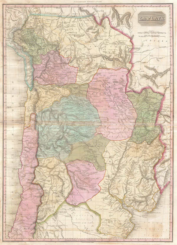
An altogether extraordinary 1818 map of the southern parts of South America by John Pinkerton. Covers the modern day countries of Argentina, Bolivia, Paraguay, Chile as well as parts of adjacent Brazil and Peru. Pinkerton offers impressive detail throughout noting indigenous groups, missions, towns and cities, swamps, mountains, and river systems. Upper left hand quadrant features the title plate and two distance scales, one in British Miles and the other in Castile Leagues.
Cartographically speaking this is an often neglected part of the world - especially in the early 19th century. Though the coastlands and open plains had been well mapped early in the 16th century, the interior was rarely penetrated. The combination of mountainous terrain, daunting jungles, malaria, and unfriendly indigenous groups combine to make this area all but unexplorable - even today. Nonetheless, Pinkerton make a commendable attempt to piece together early conquistador accounts, explorer's journals, missionary records, and indigenous reports into a coherent mapping of the area. In doing so he achieves a number of significant advances in the mapping of the region.
In general, this map reads like a litany of disappointment. The number if ruined towns, abandoned missions, forgotten mines, and destroyed settlements would be hard to match in any other map. Pinkerton notes the ruins of La Conception, St. Isabel, Santa Cruz de la Sierra, and Guadalcazar to name but a few. In the Andes, he identifies the sites of a number of important mountains and volcanoes including Aconcagua, Coquimbo, Petoroa, and others. He also identifies the site of the majestic ruined pre-Columbian city on the shores of Lake Titicaca.
Traditionally cartographers identified the apocryphal Lake of Xarayes as the source of the Paraguay River. In earlier days, explores associated this lake with legends of Paradise, El Dorado, and the gateway to the Amazon. The lake itself, though never existed. Instead it was a misinterpretation of the vast Pantanal flood plain during the rainy season. Here Pinkerton abandons the notation of a 'Lakes of Xarayes,' instead identifying numerous 'Lakes of Xarayes,' and in doing so come much closer to the truth. This is the first map to exhibit this change which is itself a significant advance the mapping of the Amazon Basin.
Drawn by L. Herbert and engraved by Samuel Neele under the direction of John Pinkerton. This map comes from the scarce American edition of Pinkerton's Modern Atlas, published by Thomas Dobson & Co. of Philadelphia in 1818.
CartographerS
John Pinkerton (February 17, 1758 - March 10, 1826) was an Scottish writer, historian, and cartographer. Pinkerton was born in Edinburgh, Scotland. He was a studious youth with a passion for the classics. As a young man, he studied at Edinburgh University before apprenticing as a lawyer. Around this time, he began writing, with his first book, Elegy on Craigmillar Castle published in 1776. Pinkerton moved to London in 1781 to pursue his writing career in earnest. He successfully published several works of literature, poetry, and history. Pinkerton proved passionate in his literary and historical writings, but his correspondence with other cartographers has been labeled as aggressive, even insane. In addition to his work as a writer and historian, Pinkerton was one of the leading masters of the Edinburgh school of cartography which flourished from roughly 1800 to 1830. Pinkerton and his contemporaries (Thomson and Cary) redefined European cartography by abandoning typical 18th century decorative elements such as elaborate title cartouches and fantastical beasts in favor of detail and accuracy. Pinkerton's principle work is Pinkerton's Modern Atlas published from 1808 through 1815 with a special American reissue by Dobson and Co. in 1818. Pinkerton relocated to Paris in 1818, where he managed his publishing business until his death in 1826. More by this mapmaker...
Thomas Dobson (1751 - 1823) was an American publisher active in Philadelphia during the late 18th and early 19th centuries. Dobson was born in Edinburgh, Scotland in 1751 and emigrated to Philadelphia c. 1780. In Philadelphia, he established a successful printing business by republishing edited and updated versions of important British reference materials in matching quality but at a much lower price point. He is best known for publishing the first American edition of the Encyclopedia Britannica. He also published America's first Hebrew Bible. Cartographically Dobson's most notable work is 1818 republication of Pinkerton's fantastic Modern Atlas. Learn More...
Source
Pinkerton, J., A Modern Atlas, from the Lates and Best Authorities, Exhibiting the Various Divisions of the World with its chief Empires, Kingdoms, and States; in Sixty Maps, carefully reduced from the Larges and Most Authentic Sources. 1818, Philadelphia, Thomas Dobson Edition.
Condition
Very good condition. Original centerfold exhibits some discoloration. Blank on verso.
References
Rumsey 0732.051. Phillips (Atlases) 724. National Maritime Museum, 409.