
1874 Reynolds Pocket City Plan or Map of London, England

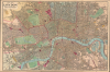

New Map of London with the Recent Improvements, 1874.
Victorian London.
- Digital Map Information
- Suitable for large format printing
- Full resolution TIFF file
- ICC color profile embedded
- Delivered instantly via download link
Victorian London.
This is a 1874 James Reynolds folding pocket city map or plan of London. It presents the city at the height of the Victorian era, when its infrastructure, including early underground railways, was developing rapidly to match its ballooning population.A Closer Look
Centered on the historic City of London, coverage embraces greater London from Kensington in the west to the West India Docks and the Isle of Dogs in the east, and from Highbury and Kentish Town at top to Peckham and Battersea at bottom. A grid of quarter-mile squares is superimposed over the map, illustrating distances. Rail and tramway (omnibus and tram) routes are traced, while railroad stations are colored pink, parks green, and cemeteries yellow. Streets, parks, government buildings, rail stations, palaces, and churches are all labeled. Several specific sites are identified as well, including the British Museum, the Millbank Penitentiary, the not-yet-completed Natural History Museum, and St. Paul's Cathedral.Victorian London
Victorian London was a remarkable place. By most measures, it was the largest and most diverse city in the world, the heart of a global empire at its height. The pioneering science fiction writer, H. G. Wells, described Victorian London as'Immense. The richest town in the world, the biggest port, the greatest manufacturing town, the Imperial city, the center of civilization, the heart of the world.Nonetheless, it was not a city without problems. The 19th-century population explosion led to sanitation problems, crime, overcrowding, ethnic discrimination, poverty, and a host of related issues - many of which became the subjects of popular Charles Dickens novels. At the same time, these very issues contributed to the development of philanthropy, urban social reform, and contemporary mass transit, making London the world's first truly modern metropolis.
This map reflects the heady atmosphere of London at the height of the Victorian era, a time when the city's population was roughly 3.5 million people. A bevy of competing private railways, including the earliest underground railways (the Metropolitan and District lines, marked with alternating white and black lines), feed into the city center from all directions. The city's administration was also chaotic and competitive, with the ancient City of London remaining fiercely independent of multiple attempts to consolidate it with surrounding parishes, districts, and counties. In addition, the vast network of rail lines, extensive docks at right, and 'new cattle market' (Metropolitan Cattle Market) at top hint at the city's economic dynamism.
Publication History and Census
This map was created and published by James Reynolds in 1874. We note two cataloged examples of the 1874 edition in OCLC, which are part of the collections at Louisiana State University, Shreveport, and the University of Alabama. Reynolds first issued this map in 1857, and it was updated annually to 1901, by which time Charles Smith and Sons had taken over the Reynolds firm.Cartographer
James Reynolds (1817-1876) was a London based map and chart publisher active in the mid-19th century. Reynolds produced numerous maps and tourist guides of London and the surrounding areas as well as various astronomical and scientific charts. After Reynolds retired his sons, William Henry and Frederick, took over his business, updating and reprinting many of his maps and charts before selling the firm to Charles Smith in the late 19th century. Reynolds operated out of office at 174 Strand Street, London. Further Details...
Condition
Good. Wear on old fold lines. Laid down on original linen backing. Stable. Folds into original red gilt and blind stamped linen binder. Interesting advertisement on verso advertising the book and print seller W. H. J. Carter. I particularly like the image of the with the prints in the window.
References
OCLC 539213470, 12086659.