
1851 Tallis Illustrated Map of London


This item has been sold.
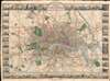
Tallis's Illustrated Plan of London and its Environs in commemoration of the Great Exhibition of Industry of all Nations, 1851.
One of the most decorative maps of London of the 19th century.
- Digital Map Information
- Suitable for large format printing
- Full resolution TIFF file
- ICC color profile embedded
- Delivered instantly via download link
One of the most decorative maps of London of the 19th century.
A superbly decorative 1851 John Tallis map of London with elaborate pictorial surround, this map was touted on its release as 'the most beautiful and perfect Plan of London ever produced.' With a finely engraved border consisting of forty illustrated views of London 'public buildings and places of amusement', the map lives up to the publisher's boisterous claim. Centered on Charing Cross, coverage extends from Stamford Hill to West Ham and from Brixton to Shepherds Bush. The map was issued to showcase the genius of British cartography, printing, and engraving at the 1851 Great Exhibition of the Works of Industry of All Nations, held in London.The Great Exhibition of the Works of Industry of All Nations
The Great Exhibition of the Works of Industry of All Nations, sometimes referred to as the Crystal Palace Exhibition in reference to the magnificent temporary structure in which it was held, was a World's Fair that took place in Hyde Park, London, from May 1 to October 15, 1851. It was the first in a series of World's Fairs: exhibitions of culture and industry that became popular in the 19th century. The Great Exhibition was organized by Henry Cole and by Prince Albert, husband of the reigning monarch of the United Kingdom, Queen Victoria. On the opening day, more than 2500 of the global elite attended.Publication History and Census
This map was published by John Tallis for release during the 1851 Industry of All National Exhibition. The map was engraved by John Rapkin. The decorative surround is the work of H. Lacey. There appears to be only one edition but in various formats including dissected here, and as foldouts in Tallis's Illustrated Atlas and Modern History of the World. Well represented institutionally but scarce on the private market.Cartographers
John Tallis (November 7, 1817 - June 3, 1876) was an English map publisher and bookseller. Born in Stourbridge, Worcestershire, he worked in his father's Birmingham agency from 1836 to 1842. Around 1838, Tallis published a collection of London Street Views and entered into a partnership with his brother Frederick Tallis from 1842 to 1849. Tallis and Company also published the Illustrated Atlas of the World (1849). Also in 1849, Tallis traveled to New York City, where he established agencies in 6 American cities. After returning from New York, Tallis paid his brother £10,000 for his share of the business and subsequently operated as John Tallis and Company until 1854. By 1853, John Tallis and Company had agencies in 26 cities in the United Kingdom, the United States, and Canada and employed over 500 people. On February 24, 1854, Tallis brought on a new partner, Ephraim Tipton Brain (1791 - 1876), forming the London Printing and Publishing Company. After a series of setbacks, however, Tallis had to sell his estate and by 1861 was declared bankrupt. Friends and former employees kept him afloat, but none of his 'various ambitious projects' proved lucrative. Tallis married Jane Ball on December 6, 1836, in Birmingham, and they lived together until she died in 1862. Tallis remarried on June 27, 1863, to Mary Stephens, with whom he had two children. Further Details...
John Rapkin (July 18, 1813 - June 20, 1899) was an English mapmaker and engraver. Born in Southwark, Rapkin was the son of George Rapkin, a shoemaker, and his wife Elizabeth Harfy. Rapkin and his brother Richard both became engravers and his other brother, William Harfy Rapkin, became a copperplate printer. Rapkin produced works for James Wyld and John Tallis, including The United States and the relative position of Oregon and Texas for Wyld around 1845, and a series of eighty maps for Tallis that became 'Tallis's illustrated atlas, and modern history of the world' in 1851. Rapkin married Frances Wilmot Rudell on January 4, 1837, with whom he had at least eight children, some of whom became engravers, including his sons John Benjamin Rapkin (1837 - 1914), Alfred Thomas Rapkin (1841 - 1905), Joseph Clarke Rapkin (1846? - 1912), and Frederick William Rapkin (1859 - 1945). Rapkin operated under the imprint 'John Rapkin and Sons from 1867 until 1883, and was operating as 'John Rapkin and Sons' by 1887. Rapkin died in 1899 at the age of 85 soon after the death of his wife of over sixty years. Further Details...
Condition
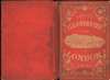
Very good. Original linen backing stable. Accompanies original red gilt-stamped binder.
References
Rumsey 11711.002. OCLC 52516930.