
This item below is out of stock, but another example (left) is available. To view the available item, click "Details."
Details
1961 Courtland Smith Pictorial Map of Long Island, New York
1961 (dated) $750.00
1933 Smith / Miller Pictorial Map of Long Island - Large Format 1st Edition
LongIsland-smith-1933-4$900.00


Title
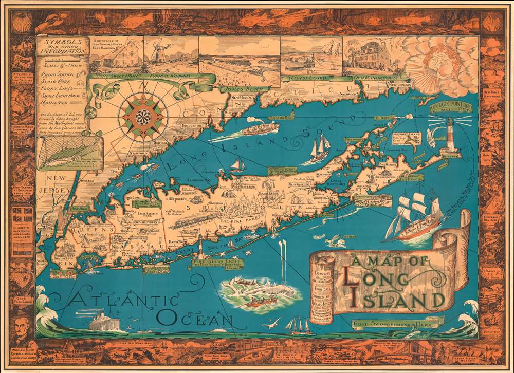
A Map of Long Island.
1933 (dated) 26.5 x 36.5 in (67.31 x 92.71 cm) 1 : 200000
1933 (dated) 26.5 x 36.5 in (67.31 x 92.71 cm) 1 : 200000
Description
The exemplar example of Courtland Smith's 1933 pictorial map of Long Island - here in the first large-format George Miller edition. This is the first time in more than 25 years that we have seen this larger format variant of this iconic and much-reproduced map (all other known examples measure 20 x 27, this example is 26.5 x 36.5 inches). This historical map covers from New London in Connecticut and Fishers Island south as far as the Lower New York Bay and Staten Island. Long Island is depicted in its entirety from Brooklyn and Queens east to Montauk. Throughout, the map notes cities, towns, beaches, radio stations, parks, ferry lines, lighthouses and several other important landmarks, scenes, and activities. Several landmarks have been attractively illustrated, including the Montauk Point Light, Fire Island Light, Southampton, Coney Island, etc. Gardiner's Island - 'here Capt. Kidd buried loot' and 'Oyster Bay - Burial Place of Theodore Roosevelt' are noted. When Smith died, the mayor of Southampton remarked about this map:
That map has had a significant impact on the development of not only Southampton, but all the other towns on Long Island that it features.
On the map
The top left quadrant of the map includes the note, 'The backbone of L.I. was formed by debris brought from the New England Mountains by two glaciers about forty thousand years ago' as well as an inset featuring a 'Diagram showing how far the two Stages of Ice Advance covered L.I.' Five beautiful, illustrated views along the top border include the Birthplace of John Howard Payne East Hampton, a Typical Windmill, Jones Beach, Coast Guard, and Old Manor House. A decorative compass rose and an art deco style wind figure are also featured. In Long Island Sound and the Atlantic Ocean, pictorial illustrations of Boston Boat, ships, striped bass, a swordfish, whale fishing, and the Sag Harbor Whalers that 'sailed to the ends of the Earth' can be seen. The map is surrounded by an elaborate border, with underwater scenes at the top and historic events and places along the remaining three sides, including the '13 Tribes of Indians when First Settlers Arrived,' 'First Settled at Brooklyn in 1614,' 'First Rail Road 1836,' 'Brooklyn Bridge 1867-1883,' etc.A Popular Map
Courtland Smith, an architect by profession, drew this map during the years of the Great Depression as a 'keep-busy project' on the suggestion of his friend Richard Foster, who is credited here for compiling the data for this map. It quickly became extremely popular and according to Courtland Smith's obituary in the Southampton Press, it became the 'steady seller in gift shops throughout Long Island for more than 75 years.'Publication History and Census
This map was drawn by Courtland Smith from data compiled by Richard Foster and published by The Billboard Barn, Southampton, L.I. The present large format edition was printed by George C. Miller, whose imprint appears in blue at the bottom of the title banner. This map became extremely popular and has since been widely reprinted. An updated and reduced version was issued later in 1933 by Gerson Offset Litho Co., Inc., New York. The second official edition appeared in 1961, and was followed by numerous subsequent copies. The present example is the original George Miller, large format, 1933 edition - which is incredibly rare. Of the two 1933 editions, there are several important distinctions. The George C. Miller edition, as here, is roughly 40% larger. Moreover, Gerson's edition features multiple towns, such as Farmingdale, Levittown, and Manorville, that do not appear on the Miller. There are also two colors schemes, which were issued simultaneously, the 'yellow and orange' as here, and the 'blue', which offers more muted tones. It is also of note that most examples of this map were varnished over to give it an 'antique' look - unfortunately, the varnish and subsequent backing on cardboard or wood often caused extreme damage. So, while later editions of the map are not uncommon, unvarnished examples of any edition in good condition are exceedingly scarce.CartographerS
Courtland Elmer Smith (December 3, 1907 - March 4, 2005) was an American architect, illustrator, and designer. He was born in Southampton, New York, the son of Elmer Smith, then village mayor. Smith studied at the University of Pennsylvania, attaining a degree in architecture in 1929, just in time for Black Tuesday. Smith worked on and off during Great Depression. In 1933, he worked with friend Richard 'Dick' Foster to compile a pictorial map of Long Island. As the Great Depression eased, Smith got more and more architecture work, becoming known for a clean uncluttered style. His work took him all over the world, and includes Houston Astrodome, the Distant Early Warning (DEW Line) radar defense system in the Arctic, and foreign aid projects for the U.S. Agency for International Development. After living abroad for many years, he returned to his native Southampton in 1966. He remained there in his family home until his death in 2005. (The Southampton Press, March 10, 2005) More by this mapmaker...
George Charles Miller (June 17, 1894 - October 21, 1965) was an American lithographer and publisher. He was born in New York City into a commercial printing family, and began his apprenticeship in the family business at 15. He completed his apprenticeship at the American Lithographic Company. Miller served in World War I. He is notable for having recognized early on the value of printing for artists, and would eventually print exclusively for artists: one of only a few American printers to do so. Not only did he print artists' work, but he also trained artists (Ruth Haviland Sutton among them) in the craft of lithography. He was married to Carrie Scharsmith Miller, and lived most of his life in Lynbrook, Long Island, New York. He also had a home in Burlington, Vermont, where he died of a heart attack in 1965. Miller's son, Burris G. Miller (1928 - 2017) took over the business, until retiring in 1994. Learn More...
Condition
Very good. A few minor margin repairs along bottom margin, left side, and along right side. Archival verso reinforcement along all edges.