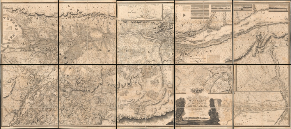
1815 Bouchette Masterplan of Lower Canada (Ontario) and Lake Champlain
LowerCanada-bouchette-1815$25,000.00


Title
To His Royal Highness George Augustus Frederick, Prince of Wales, Duke of Cornwall ... and Prince Regent of the United Kingdom of Great Britain and Ireland; this Topographical map of the Province of Lower Canada, shewing its division into Districts, Counties, Seigniories, and Townships with all the Lands reserved both for the Crown and the Clergy ... Is with his Royal Hyghnes's Special Permission, Most gratefully dedicated by a Faithful and Zealous Canadian Subject, and His Royal Highnes's Most Obedient and Devoted Servant, Joseph Bouchette, His Majesty's Surveyor General of the Province and Lieutt. Colonel C.M.
1815 (dated) 59 x 132.75 in (149.86 x 337.185 cm) 1 : 174240
1815 (dated) 59 x 132.75 in (149.86 x 337.185 cm) 1 : 174240
Description
This is Joseph Bouchette's monumental 10-sheet map of Lower Canada. Appearing at the end of the War of 1812, this is the largest, best, and most influential map of Canada issued in the 19th century. David Rumsey correctly praises it, saying that the 'graphic elegance of the large map is the equal (or perhaps the superior) of any of the contemporary maps that I have seen'. In its pre-publication manuscript form, it played a significant role in the Treaty of Ghent, which ended the War of 1812 and began the establishment of formal U.S.-Canada borders. Due to its extreme rarity, the significance of this map is often overlooked, and it is poorly represented in scholarly literature.
The U.S.-Canada border is clear, running from St. Regis at the left-most edge of the map to the Connecticut River. Beyond this point, the political geography gets considerably more vague, with much of western Maine obscured by the title cartouche and insets. East of the insets, the primary map resumes, taking in parts of Northern Maine in the Eagle Lakes region, west of the important St. John's River. Although the 'Province of Maine' is noted, it extends well into what is today western New Brunswick. There are no defined borders with Maine, reflecting ambiguity related to the in-progress negotiations at Ghent ending the War of 1812 (1812 - 1815).
Three significant inset maps detail Quebec City, Montreal, and Trois-Rivières. The enormity of Bouchette's map means that, although insets, these city maps offer significant detail, clearly identifying individual buildings, streets, gardens, and more. In addition, there are 5 coastal profile views illustrating critical points along the St. Lawrence River.
We note an unambiguous distinction between the old French Seigneurial Grants - enormous Seigneuries are most evident along the St. Lawrence - and the smaller-scale and more rigid English plat system is apparent Eastern Townships, where we see meticulously surveyed townships of about ten miles square partitioned into ranges, themselves divided into rectangular lots of about 200 acres each.
Within the English system, there are four types of land use,
In the preface of the volume associated with this map, Topographical Description of Lower Canada (not present), he describes his intent for this massive and detailed map,
The massive map was extensively praised in scientific circles. In April 1816, the Society for the Encouragement of Arts, Manufactures, and Commerce in London granted Bouchette a gold medal in honor of the achievement. Back in Canada, Bouchette received another mark of appreciation: a grant from seigneur Alexander Fraser of a quarter of the seigneuries of Madawaska and Lac Témiscouata.
In the end, despite the size, accuracy, and utility of Bouchette's map, the Canadian Legislature reneged on the promised funds. It was not until 1875 that Bouchette's heirs were compensated, though without the considerable interest accrued on the long overdue payment.
For such an excellent and important map, it is impressively rare. The OCLC records examples at the Redwood Library and Athenaeum, the University of Michigan Clements Library, the American Antiquarian Society, Boston Athenaeum, and the Bibliothèque et Archives Nationales du Québec. We note additional examples in Library and Archives Canada, the Library of Congress, and the David Rumsey Collection. Most other examples, both online and in OCLC, are digital resources copied from the David Rumsey example.
A Closer Look
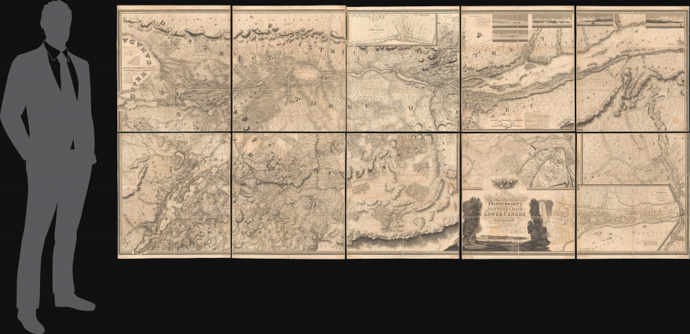
The map is here presented on 10 sheets, each dissected and laid on linen in 6 sections. Oriented to the northwest to accommodate the orientation of the St. Lawrence River, coverage embraces from Lake St. Francis (just west of Montreal) and Lake Champlain east as far as Lake Témiscouata and Trois-Pistoles and south to include Lake Champlain as far as Crown Point, thus including large portions of northern New York, Vermont, New Hampshire, and Maine. Remarkably, this map's detail is in no way diminished beyond its areas of focus in Lower Canada, incorporating considerable valuable content within the United States, particularly in the vicinity of Lake Champlain - a critical theater in the War of 1812.The U.S.-Canada border is clear, running from St. Regis at the left-most edge of the map to the Connecticut River. Beyond this point, the political geography gets considerably more vague, with much of western Maine obscured by the title cartouche and insets. East of the insets, the primary map resumes, taking in parts of Northern Maine in the Eagle Lakes region, west of the important St. John's River. Although the 'Province of Maine' is noted, it extends well into what is today western New Brunswick. There are no defined borders with Maine, reflecting ambiguity related to the in-progress negotiations at Ghent ending the War of 1812 (1812 - 1815).
Three significant inset maps detail Quebec City, Montreal, and Trois-Rivières. The enormity of Bouchette's map means that, although insets, these city maps offer significant detail, clearly identifying individual buildings, streets, gardens, and more. In addition, there are 5 coastal profile views illustrating critical points along the St. Lawrence River.
We note an unambiguous distinction between the old French Seigneurial Grants - enormous Seigneuries are most evident along the St. Lawrence - and the smaller-scale and more rigid English plat system is apparent Eastern Townships, where we see meticulously surveyed townships of about ten miles square partitioned into ranges, themselves divided into rectangular lots of about 200 acres each.
Within the English system, there are four types of land use,
The small, dotted lines within the Townships shew the granted parts thereof. The lots which are shaded dark are reserved for the maintenance and support of the Protestant Clergy within the Province, and those of a lighter shade reserved for the future disposition of his Majesty.The map is titled in an impressive, engraved cartouche in the lower right. The cartouche features illustrations of Canadian flora, Niagara Falls, and indigenous peoples set around the title and a panoramic view of Quebec City from across the St. Lawrence.
Historical Context
This map appeared at the end of the War of 1812. Although neither Great Britain nor the United States made significant gains, the true victors may have been Canadians, who emerged from the war with a renewed sense of national identity and solidarity. Part of this was pride in their vast resource-rich territory, which Bouchette believed was ready for exploitation.In the preface of the volume associated with this map, Topographical Description of Lower Canada (not present), he describes his intent for this massive and detailed map,
The interior of Lower Canada being so little known beyond the limits of the Province, a belief that a detailed account of it would not only be useful in shewing its present state, but by bringing it under more general notice, might possibly assist in the development of its vast resources, has led to the construction of a topographical map upon a large scale…Thus, writes historian Don Thomson (Men and Meridians),
In 1814 a committee of the legislature of Lower Canada recommended that he be granted £1,500 in aid of his proposed publication of a map-illustrated catalogue of information on the Province. That summer, supported by a £500 advance on the grant, Lieut.-Colonel Bouchette again proceeded to England.When Bouchette arrived in Europe, the Ghent negotiations to end the War of 1812 were in progress. His cartographic expertise was harnessed by the British authorities, who made him a special surveyor under the Ghent Provisions Article 5 to work out, along with an American counterpart, a firm Canada-US border. While this map was not yet published, there can be no doubt that it, in its manuscript or proof form, was utilized in these negotiations, being by far the best cartographic representation of the U.S.-Canada borderlands obtainable and the work of one of the chief contracted surveyors.
The massive map was extensively praised in scientific circles. In April 1816, the Society for the Encouragement of Arts, Manufactures, and Commerce in London granted Bouchette a gold medal in honor of the achievement. Back in Canada, Bouchette received another mark of appreciation: a grant from seigneur Alexander Fraser of a quarter of the seigneuries of Madawaska and Lac Témiscouata.
In the end, despite the size, accuracy, and utility of Bouchette's map, the Canadian Legislature reneged on the promised funds. It was not until 1875 that Bouchette's heirs were compensated, though without the considerable interest accrued on the long overdue payment.
Publication History and Census
This map was drafted by Joseph Bouchette based on survey work completed during and before the War of 1812 (1812 - 1815). It was engraved in London by John Waker and published by William Faden. The map was intended to illustrate Bouchette's Topographical Description of Lower Canada, the atlas for which includes this 10-sheet map, a 2-sheet map of Upper and Lower Canada, and a single-sheet map of Gaspe. This present example is a separate issue, dissected and laid on linen.For such an excellent and important map, it is impressively rare. The OCLC records examples at the Redwood Library and Athenaeum, the University of Michigan Clements Library, the American Antiquarian Society, Boston Athenaeum, and the Bibliothèque et Archives Nationales du Québec. We note additional examples in Library and Archives Canada, the Library of Congress, and the David Rumsey Collection. Most other examples, both online and in OCLC, are digital resources copied from the David Rumsey example.
CartographerS
Joseph Bouchette (May 14, 1774 - April 8, 1841) was a British Canadian military officer and cartographer. Bouchette was born in Quebec City, the son of Jean-Baptiste Bouchette, a military topographer and naval officer, and Marie Angelique Duhamel, daughter of Julien Duhamel (1723 - 1778). During the American Revolutionary War (1775 - 1783), Joseph's father famously saved the life of General Guy Carleton (1724 - 1808), Commander-in-Chief of the British Forces in North America, navigating him and his family along the Saint Lawrence River from Montreal, through the American lines, to Quebec. This accomplishment has significant ramifications for both the war, reversing the outcome of the 1775 Battle of Quebec, and the Bouchette family, earning Bouchette a grant of 6,000 acres and a significant military promotion. Joseph, now practically a nobleman, followed his father as a topographer and naval officer. He initially studied art and architecture under François Baillairgé (1759 - 1830), but in 1790, after a short and distinguished naval career, Bouchette entered the service of his (now elderly) uncle Samuel Holland (1728 - 1801), the first Surveyor-General of British North America. He moved to Quebec to work at the Surveyor General's offices and found the offices in disarray. Bouchette took on the task of reorganizing the offices, earning him the official position of Surveyor-General after Holland's death. With Charles Burton Wyatt, Bouchette resurveyed Lower Canada from 1805 to 1807. This work was compiled and published in 1815 as the Topographical Description of the Province of Lower Canada, which was the sum of all contemporaneous knowledge of the territory. He held the position of Surveyor General until 1826 when he retired, and the position was taken up by his son, Joseph-Francis Bouchette (1800 - 1881). After he died in 1841, he was entombed in Montreal's Notre Dame des Neiges Cemetery. More by this mapmaker...
William Faden (July 11, 1749 - March 21, 1836) was a Scottish cartographer and map publisher of the late 18th century. Faden was born in London. His father, William MacFaden, was a well-known London printer and publisher of The Literary Magazine. During the Jacobite Rebellion (1745 - 1746), MacFaden changed his family name to Faden, to avoid anti-Scottish sentiment. Faden apprenticed under the engraver James Wigley (1700 - 1782), attaining his freedom in 1771 - in the same year that Thomas Jefferys Sr. died. While Thomas Jefferys Sr. was an important and masterful mapmaker, he was a terrible businessman, and his son, Jefferys Jr., had little interest in building on his father's legacy. MacFaden, perhaps recognizing an opportunity, purchased his son a partnership in the Jefferys firm, which subsequently traded as 'Faden and Jefferys'. Jefferys Jr. also inherited Jefferys Sr.'s title, 'Geographer to the King and to the Prince of Wales'. With little interest in cartography or map publishing, Jefferys Jr. increasingly took a back seat to Faden, and by 1776, he had withdrawn from day-to-day management, although he retained his financial stake. The American Revolutionary War (1775 - 1783) proved to be a boom for the young 'Geographer to the King', who leveraged existing materials and unpublished manuscript maps to which he had access via his official appointment to publish a wealth of important maps, both for official use and the curious public - this period of prosperity laid the financial underpinning for Faden, who by 1783, at the end of the war, acquired full ownership of the firm and removed the Jefferys imprint. In 1801, he engraved and published the first maps for the British Ordnance Survey. By 1822, Faden published over 350 maps, atlases, and military plans. He retired in 1823, selling his plates to James Wyld Sr. Faden died in 1836. Learn More...
John Walker (1787 - April 19, 1873) was a British map seller, engraver, lithographer, hydrographer, geographer, draughtsman, and publisher active in London during the 19th century. Walker published both nautical charts and geographical maps. His nautical work is particularly distinguished as he was an official hydrographer for the British East India Company, a position, incidentally, also held by his father of the same name. Walker's maps, mostly published after 1827, were primarily produced with his brothers Charles Walker and Alexander Walker under the imprint J. and C. Walker. Among their joint projects are more than 200 maps for the influential Society for the Diffusion of Useful Knowledge Atlas (SDUK). In addition they published numerous charts for James Horsburgh and the British Admiralty Hydrographic Office, including Belcher's important map of Hong Kong and Carless' exploratory map of Karachi. The J. and C. Walker firm continued to publish after both Walkers died in the 1870s. Learn More...
Condition
Very good. Laid down on original linen 10 sectionalized panels. Some minor offsetting and edge wear.
References
Rumsey 4431.011. OCLC 210101669, 49017948. Sabin, J., A Dictionary of Books Relating to America: from its Discovery to the Present Time, #6849. Thomson, D. W., Men and Meridians: The History of Surveying and Mapping in Canada, pages 264-266.