This item has been sold, but you can get on the Waitlist to be notified if another example becomes available, or purchase a digital scan.
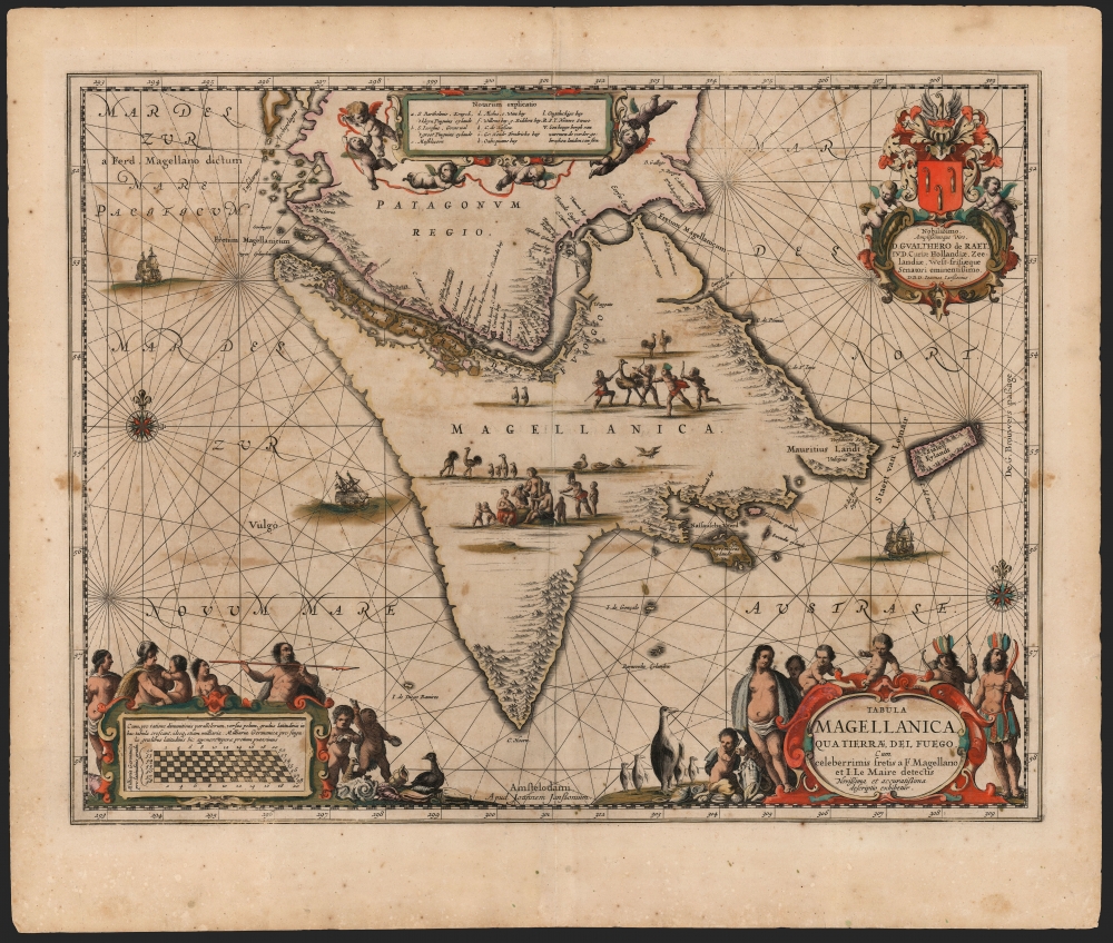
1647 Jansson Map of Tierra Del Fuego
Magellanica-jansson-1647$600.00

Title
Tabula Magellanica qua Tierrae del Fuego et I. Le Maire detectis Novissima et accuratissima descriptio exhibetur.
1647 (undated) 16 x 20.75 in (40.64 x 52.705 cm) 1 : 2000000
1647 (undated) 16 x 20.75 in (40.64 x 52.705 cm) 1 : 2000000
Description
This is an example of the most beautifully engraved 17th century map of Tierra del Fuego, engraved by Jan Jansson for inclusion in his atlases in 1646. It is the third map in the Hondius-Janssonius atlases to focus on this region, and was added to bring Jansson's mapping of the southernmost part of America up to date. The present depiction is the result of over a century of exploration, revealing the discoveries of Magellan, Le Maire and Schouten, and finally the voyage made by Jacques l'Hermite with the so-called Nassau Fleet between 1623 and 1624.
Discoveries On The Map
This work portrays Tierra del Fuego as a large island (in reality, the western parts of the island depicted here are an archipelago.) The island's northern limits are marked with the Strait of Magellan; its inlets are sufficiently detailed that a table of place names (keyed with letters to the map) was required to fit them. The discovery of this passage in 1522 by the Portuguese Ferdinand Magellan opened the age of global discovery. It was, however, left to the Dutch explorers Le Maire and Schouten during their 1615-1617 circumnavigation to definitively show Tierra del Fuego to be an island, rather than part of a massive Terra Australis. Part of their goal being to circumvent the Portuguese hold on the Strait of Magellan, Le Maire and Schouten were able to sail around Cape Horn and pass to the Pacific without using the Portuguese route. In doing so, they passed through the strait that took Le Maire's name - between Tierra del Fuego and what they termed Staten Eylandt. Maps including the new strait would enter the Hondius atlas as early as 1618, with a specific map added in 1630.Nodal Expedition
The presence off the west coast of Tierra del Fuego of the Isla de Diego Ramires and the Entrada de St. Sebastian reveal knowledge of the 1619 Nodal Expedition. This voyage, sponsored by King Philip III of Spain, was intended to confirm the by-then famous discoveries of Le Maire and Schouten. Led by brothers Bartolome and Gonzalo Garcia de Nodal, the expedition lasted from September 27, 1618 to July 7, 1619, having achieved its goals with no loss of life. Despite the notoriously secretive Spanish bureaucracy, some detail was able to reach the Dutch to be preserved here.The Nassau Fleet
At the command of Prince Maurice of Nassau, in 1623 the newly-chartered West India Company sent a fleet under Jacques l'Hermite to attack Spanish ports and shipping on the west coast of South America. Having passed through the Strait of Le Maire, the fleet scattered. As a result, one of the ships under a Captain Verschoor discovered Nassau Bay. The fleet's mathematician, Joannes Walbeeck, drew a chart of the bay and its surrounding islands. This in turn was executed by Hessel Gerritz in a small map entitled Zuydsyde van Tierra del Fuego, included in the 1626 journal of the voyage. Gerritz' map has been reproduced here on the southeastern coast of Tierra del Fuego. Its details include Nassau Bay, Schapenhams bay, Ewoudts island, Barnevelds island, and Lheremitens eyland (named after the ill-fated Jacques l'Hermite, the commander of the voyage who would die of scurvy and dysentery in 1624, before its completion).Anything You Can Do I Can Do Louder
The first appearance of this cartography was the Tabula Magellanica produced by Jansson's chief competitor, Willem Blaeu in 1630. Jansson's map faithfully copies the map itself, its place names, and its topography. Having learned well from the fierce rivalry between the two neighboring firms, Jansson far outdid Blaeu in the beautifying of his work. The map is filled with many imaginative portrayals of indigenous Patagonians - gathered as families, posing with weapons, and hunting ostriches. The cartouches are similarly decorated, including a crowd of putti playing amid piles of seashells. In addition to the oddly chosen ostrich, crowds of penguins stand about. The upper right corner is embellished with a sumptuous dedication to Dutch senator Gualthero de Raet, surmounted with the dedicatee's arms. In comparison, the earlier Blaeu map is spartan.Publication History and Census
This map was composed and first printed by Jan Jansson in 1646 for inclusion in his Atlas Novus. In its first appearance, the dedicatory cartouche and much of the decorative engraving was incomplete. This example of the second state, with the completed dedication, appeared in the 1647 Latin edition of the atlas. Perhaps twenty separate examples appear in institutional collections.CartographerS
Jan Jansson or Johannes Janssonius (1588 - 1664) was born in Arnhem, Holland. He was the son of a printer and bookseller and in 1612 married into the cartographically prominent Hondius family. Following his marriage he moved to Amsterdam where he worked as a book publisher. It was not until 1616 that Jansson produced his first maps, most of which were heavily influenced by Blaeu. In the mid 1630s Jansson partnered with his brother-in-law, Henricus Hondius, to produce his important work, the eleven volume Atlas Major. About this time, Jansson's name also begins to appear on Hondius reissues of notable Mercator/Hondius atlases. Jansson's last major work was his issue of the 1646 full edition of Jansson's English Country Maps. Following Jansson's death in 1664 the company was taken over by Jansson's brother-in-law Johannes Waesberger. Waesberger adopted the name of Jansonius and published a new Atlas Contractus in two volumes with Jansson's other son-in-law Elizée Weyerstraet with the imprint 'Joannis Janssonii haeredes' in 1666. These maps also refer to the firm of Janssonius-Waesbergius. The name of Moses Pitt, an English map publisher, was added to the Janssonius-Waesbergius imprint for maps printed in England for use in Pitt's English Atlas. More by this mapmaker...
Willem Janszoon Blaeu (1571 - October 18, 1638), also known as Guillaume Blaeu and Guiljelmus Janssonius Caesius, was a Dutch cartographer, globemaker, and astronomer active in Amsterdam during the late 16th and early 17th centuries. Blaeu was born 'Willem Janszoon' in Alkmaar, North Holland to a prosperous herring packing and trading family of Dutch Reformist faith. As a young man, he was sent to Amsterdam to apprentice in the family business, but he found the herring trade dull and instead worked for his cousin 'Hooft' as a carpenter and clerk. In 1595, he traveled to the small Swedish island of Hven to study astronomy under the Danish Enlightenment polymath Tycho Brahe. For six months he studied astronomy, cartography, instrument making, globe making, and geodesy. He returned to Alkmaar in 1596 to marry and for the birth of his first son, Johannes (Joan) Blaeu (1596 – 1673). Shortly thereafter, in 1598 or 1599, he relocated his family to Amsterdam where he founded the a firm as globe and instrument makers. Many of his earliest imprints, from roughly form 1599 - 1633, bear the imprint 'Guiljelmus Janssonius Caesius' or simply 'G: Jansonius'. In 1613, Johannes Janssonius, also a mapmaker, married Elizabeth Hondius, the daughter of Willem's primary competitor Jodocus Hondius the Elder, and moved to the same neighborhood. This led to considerable confusion and may have spurred Willam Janszoon to adopt the 'Blaeu' patronym. All maps after 1633 bear the Guiljelmus Blaeu imprint. Around this time, he also began issuing separate issue nautical charts and wall maps – which as we see from Vermeer's paintings were popular with Dutch merchants as decorative items – and invented the Dutch Printing Press. As a non-Calvinist Blaeu was a persona non grata to the ruling elite and so he partnered with Hessel Gerritsz to develop his business. In 1619, Blaeu arranged for Gerritsz to be appointed official cartographer to the VOC, an extremely lucrative position that that, in the slightly more liberal environment of the 1630s, he managed to see passed to his eldest son, Johannes. In 1633, he was also appointed official cartographer of the Dutch Republic. Blaeu's most significant work is his 1635 publication of the Theatrum orbis terrarum, sive, Atlas Novus, one of the greatest atlases of all time. He died three years later, in 1638, passing the Blaeu firm on to his two sons, Cornelius (1616 - 1648) and Johannes Blaeu (September 23, 1596 - December 21, 1673). Under his sons, the firm continued to prosper until the 1672 Great Fire of Amsterdam destroyed their offices and most of their printing plates. Willem's most enduring legacy was most likely the VOC contract, which ultimately passed to Johannes' son, Johannes II, who held the position until 1617. As a hobbyist astronomer, Blaeu discovered the star now known as P. Cygni. Learn More...
Hessel Gerritsz (1581 – September 4, 1632) was a Dutch engraver, cartographer, and publisher active in Amsterdam during the late 16th and early 17th centuries, among the most preeminent Dutch geographers of the 17th century. He was born in Assum, a town in northern Holland in 1581. As a young man he relocated to Alkmaar to accept an apprenticeship with Willem Jansz Blaeu (1571-1638). He followed Blaeu to Amsterdam shortly afterwards. By 1610 he has his own press, but remained close to Blaeu, who published many of his maps. In October of 1617 he was appointed the first official cartographer of the Vereenigde Oost-Indische Compagnie (Dutch East Indian Company) or VOC. This strategic position offered him unprecedented access to the most advanced and far-reaching cartographic data of the Dutch Golden Age. Unlike many cartographers of his period, Gerritsz was more than a simple scholar and showed a true fascination with the world and eagerness to learn more of the world he was mapping in a practical manner. In 1628 he joined a voyage to the New World which resulted in the production of his seminal maps, published by Joannes de Laet in his 1630 Beschrijvinghe van West-Indien; these would be aggressively copied by both the Blaeu and Hondius houses, and long represented the standard followed in the mapping of the new world. Among his other prominent works are a world map of 1612, a 1613 map of Russia by the brilliant Russian prince Fyodor II Borisovich Godunov (1589 – 1605), a 1618 map of the pacific that includes the first mapping of Australia, and an influential 1630 map of Florida. Gerritsz died in 1632. His position with the VOC, along with many of his printing plates, were taken over by Willem Janszoon Blaeu. Learn More...
Source
Jansson, J., Atlas Novus, (Amsterdam: Jansson) 1647.
Condition
Very good. Some offsetting from oxidation of old color; centerfold reinforced. Else excellent with rich original color.
References
OCLC 124069241. Rumsey 11755.130 (added to Visscher atlas in 1690).