1873 Weller Map of Maghian, Western Tajikistan
Maghian-murray-1873$250.00

Title
Notes on M. Fedchenko's Map of Maghian.
1873 (dated) 7.5 x 10.5 in (19.05 x 26.67 cm) 1 : 422400
1873 (dated) 7.5 x 10.5 in (19.05 x 26.67 cm) 1 : 422400
Description
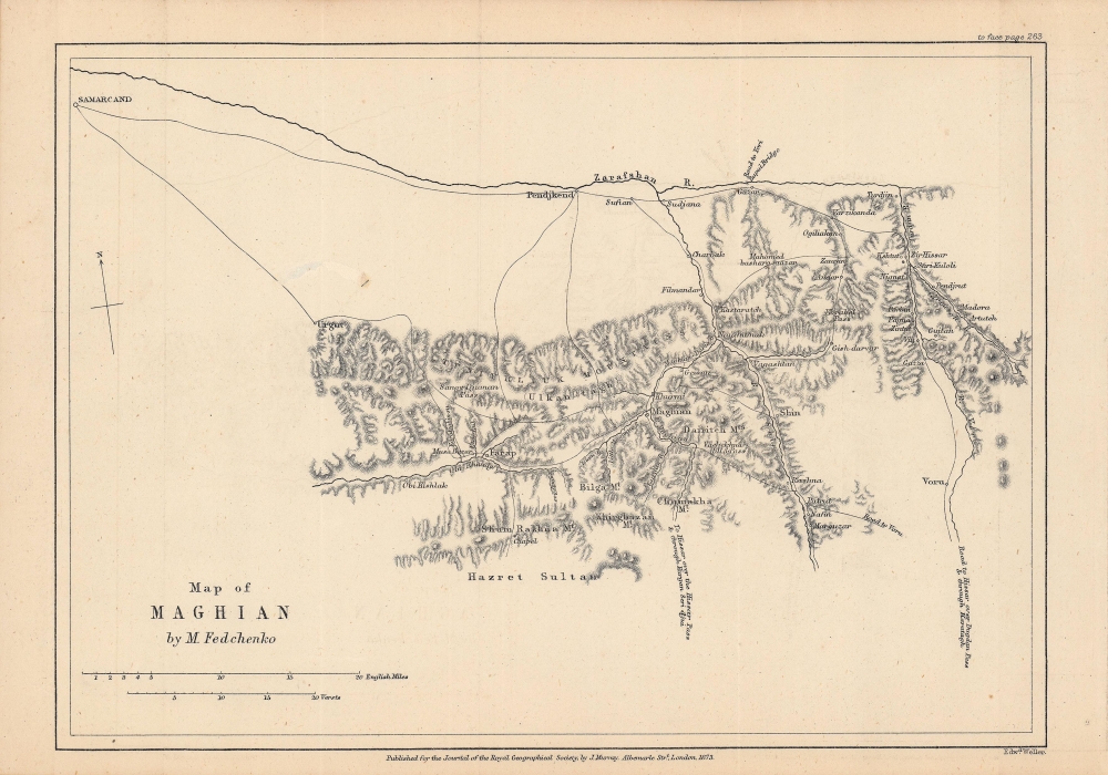
This is an 1873 map of 'Maghian,' that is, the area that now comprises the westernmost portion of Sughd Province in Tajikistan, along the border with Uzbekistan. Based on a Russian map by Alexei Fedchenko, it was lithographed by Edward Weller and published by John Murray in the Journal of the Royal Geographical Society.
A Closer Look
Coverage extends from Samarkand (Samarcand) at top-left, along the Zarafshan (Zeravshan) River at top and southwards through the Zeravshan Mountain Range. This region now forms the westernmost portion of Tajikistan, along the border with Uzbekistan. Aside from the Zeravshan River and mountain range, other names still in use are recognizable, such as Pendjkend (Panjakent) and Guzar (Gusar). In addition to mountains and rivers, roads and settlements are also indicated. Scales are given in English miles and (Russian) versts.The Tsar Comes for Sogdiana
This region was the traditional heartland of the Sogdians, the great traders of Central Asia in the era preceding the arrival of Islam in the 7th - 8th centuries CE. At the time this map was published, the area had recently been conquered by the Russian Empire and incorporated into its Turkestan General Governorate. At the time the Great Game was in full force. The British warily watched Russia's expansion into Central Asia, as the two massive empires jockeyed for position in the 'Great Game.'The Great Game
'The Great Game' was a diplomatic confrontation between the British and Russian Empires over Afghanistan and other territories in Central and Southern Asia. The conflict, rooted in long-standing animosity between Russia and Britain, revolved around Afghanistan, which, while lacking significant resources of its own, was strategically situated. For its part, Russia feared Britain was making commercial and military inroads into Central Asia, an area long within the sphere of influence of St. Petersburg. Britain, conversely, feared Russia making gains in India, 'the jewel in the crown' of British Asia. The escalating tensions led to several wars and proxy wars: The First Anglo-Afghan War (1839 - 1842), the First Anglo-Sikh War (1845 - 1846), the Second Anglo-Sikh War (1848 - 1849), and the Second Anglo-Afghan War (1878 - 1880), along with the Russian annexations of Khiva, Bukhara, and Kokand. Then as now, Afghanistan proved a grinding stone upon which the world's great empires diminished themselves, none achieving a definitive victory despite committing staggering resources. The Great Game 'ended' on September 10, 1895, with the signing of the Pamir Boundary Commission Protocols, which stabilized the border between Afghanistan and the Russian Empire - but well into the 20th century the British were well aware the conflict remained. Regarding the attitude of Afghans to the British and to the Russians, the general assumption of the British was that 'Some will fight for us, some against us, but all will fight.'Publication History and Census
This map was lithographed by Edward Weller and published by the firm John Murray. It appeared in 1873 in Volume 43 of the Journal of the Royal Geographical Society to accompany an article by Robert Michell, presumably a member of the Royal Geographical Society, who occasionally translated maps and texts from Russian to English. Michell's article is mainly a translation of the map and an accompanying description originally done by Alexei Pavlovich Fedchenko (Алексей Павлович Федченко), a well-known naturalist and explorer of Central Asia (who, incidentally, died in 1873 while climbing Mont Blanc), in Proceedings of the Russian Society of Natural Science, Anthropology, and Ethnography (Известия Императорского Общества Любителей Естествознания, Антропологии И Этнографии). The English-language map is independently cataloged by Princeton University and is scarce to the market, while the entire 1873 volume of the Journal of the Royal Geographical Society is well-represented in the holdings of major research institutions.CartographerS
John Murray I (1737 - 1793) founded the British publishing firm John Murray (1768 - present) in London. Born in Edinburgh, Murray served as an officer in the Royal Marines and built a list of authors that included Isaac D’Israeli and published the English Review. Murray the elder also was one of the founding sponsors of the London evening newspaper The Star in 1788. John Murray II (November 27 1778 - June 27, 1843) continued the family publishing business and developed it into one of the most important and influential publishing houses in Britain. The list of authors published by the firm grew to include Jane Austen, Sir Walter Scott, Washington Irving, George Crabbe, and Lord Byron under his tenure. Murray II also moved the business to 50 Albermarle Street in Mayfair, which became famous for Murray’s tradition of ‘four o’clock friends’, which was afternoon tea with his writers. John Murray III (1808 - 1892) continued to grow the business, and the firm published the first English translation of Goethe’s Theory of Colours, David Livingstone’s Missionary Travels and Charles Darwin’s Origin of Species during his tenure. Murray also published Herman Melville’s first two books. The firm began publishing Murray Handbooks in 1836, an ancestor of all modern travel guides. Sir John Murray IV (1851 - 1928) was publisher to Queen Victoria. Three successive Murray’s after Murray IV led the business until it was purchased by Hodder Headline in 2002, which was acquired by the French conglomerate Lagardère Group in 2004. Today, Murray is an imprint of Lagardère under the imprint Hachette UK. More by this mapmaker...
Edward Weller (July 1, 1819 - 1884) was a cartographer and engraver based in London. Weller was a nephew of another well-known map publisher Sidney Hall (1788 - 1831), who gave him 50 Pounds to pay his apprenticeship fees. He engraved for many prominent mapmakers and was active enough in the community to be recommended for membership to the Royal Geographical Society in 1851 on the recommendation of John Arrowsmith, among others. He eventually inherited the Sidney Hall map business which led him to follow Arrowsmith as the unofficial geographer to the Royal Geographical Society. Weller was among the first map printers in London to embrace lithography. His best known work appears in Cassell's Weekly Dispatch Atlas, published in monthly segments for subscribers of the 'Weekly Dispatch' newspaper. This collection of maps eventually grew to include much of the known world. Published in various editions from 1855 through the early 1880s. Weller died in May of 1884, leaving behind a successful business and an unhappy widow. His son, Francis Sidney Weller (1849 - 1910), followed in his father's footsteps and continued the family map business. The atlas Mackenzie's Comprehensive Gazetteer of England and Wales was published in 1894 and bore F. S. Weller's signature on the maps. Learn More...
Royal Geographical Society (fl. 1830 - present) is a British Society established in 1830 to promote geographical science and exploration. Originally titled the "Geographical Society of London", the RGS received its royal charter from Queen Victoria in 1859 shortly after absorbing several similar but more regional societies including the African Association, the Raleigh Club and the Palestine Association. The RGS sponsored many of the most important and exciting voyages of exploration ever undertaken, including the exploration of Charles Darwin, David Livingstone, Robert Falcon Scott, Richard F. Burton, John Speke, George Hayward, H. M Stanley, Ernest Shackleton and Sir Edmond Hillary. Today, the RGS remains a leading global sponsor of geographical and scientific studies. The Society is based in Lowther Lodge, South Kensington, London. Learn More...
Source
Michell, R., 'Notes on M. Fedchenko's Map of Maghian'. Journal of the Royal Geographical Society (London: John Murray) 1873.
Condition
Very good. Some creasing along fold lines. Repaired area of loss towards top-left.
References
OCLC 1340203266.