
1929 Admiralty Nautical Chart / Map of Singapore, Malaya, Malacca Strait

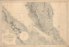

Malacca Strait with part of the East Coast of the Malay Peninsula from the latest British and Foreign Government Surveys.
Malaya and Singapore in the Interwar Period.
- Digital Map Information
- Suitable for large format printing
- Full resolution TIFF file
- ICC color profile embedded
- Delivered instantly via download link
Malaya and Singapore in the Interwar Period.
This is a 1929 British Admiralty nautical chart or maritime map of the Malay Peninsula, Singapore, and the Strait of Malacca. It captures the Strait during the Interwar Period (1918 - 1939), when Malaya was the world's largest single source of both rubber and tin, and when the British sought to protect this vitally important waterway from foreign aggression.A Closer Look
Coverage extends roughly from Penang to Pulo Bintang (Bintan Island), including the southern part of Malaya and the eastern coast of Sumatra. The chart offers countless depth soundings and excellent inland detail, particularly in Perak and Selangor. Yellow ink marks coastal lights and beacons. Information on hazards, shoals, bottoms, and tides is also included, along with three compass roses noting magnetic variation. In addition to Singapore, the cities and ports of Kuala Lumpur, Georgetown, and Malacca are clearly identifiable. A small pastedown is included around Batu Pahat with updated soundings. A signature in blue pencil appears at the bottom-left.Historical Context
During the Interwar Period (1918 - 1939), the Strait of Malacca solidified its position as one of the world's most critical maritime chokepoints, serving as both a commercial conduit and a strategic military linchpin. Economically, the Strait facilitated the rapid flow of global trade, funneling highly sought-after commodities, especially rubber and tin from British Malaya, to Western markets, cementing Singapore's status as the dominant regional entrepôt in the process. Militarily, the waterway became a focal point of imperial anxiety as Imperial Japan's expansion threatened Western colonial holdings. In response, the British implemented the 'Singapore Strategy,' constructing a 'Gibraltar of the East' at the Strait's southern tip to deter Japanese aggression and safeguard the vital sea lanes connecting the Indian Ocean to the Pacific. Unfortunately for the British, they had not extensively prepared for the possibility of an invasion from the Malaya side of Singapore, across the Straits of Johor, a fact which the Japanese exploited to devastating effect in early 1942.Publication History and Census
This chart was first engraved by the British Admiralty Hydrographic Office in 1898. It went through numerous updates and revisions, the most recent major revision being a new edition in 1922. The present chart features minor corrections and updates to 1929. This chart, in its various editions, is cataloged at a small handful of institutions. We have only found one other example of this second (1931) edition before the 'large corrections' added after World War II, which is held by the Bibliotheek Universiteit van Amsterdam.Cartographer
The British Admiralty Office (1795 - Present) or the United Kingdom Hydrographic Office refers to the Branch of the English government that is responsible for the command of the British Navy. In 1795 King George III created the United Kingdom Hydrographic Office, known in short as the U.K.H.O., to provide top notch nautical charts to the vast Royal Navy. Prior the founding of the Admiralty the surveying and creation of nautical charts was primarily a commercial venture wherein the cartographer himself, more of than not, actually financed the printing of his own material. The great navigator Cook himself is known to have scrambled for funds to publish his own seminal charts - the most important and advanced of the period. The system of privately funded nautical mapping and publishing left vast portions of the world uncharted and many excellent charts unpublished. King George III, responding significant loss in trade revenue related to shipwrecks and delay due to poor charts, recognized the need for an institutionalized government sponsored cartographic agency - the Admiralty. The first head of the Admiralty, a position known as Hydrographer, was the important cartographer Alexander Dalrymple. Dalrymple started by organizing and cataloging obtainable charts before initiating the laborious process of updating them and filling in the blanks. The first official Admiralty Chart appeared in 1800 and detailed Quiberon Bay in Brittany. By 1808 the position of Hydrographer fell to Captain Thomas Hurd. Hurd advocated the sale of Admiralty charts to the general public and, by the time he retired in 1829, had issued and published some 736 charts. Stewardship of the organization then passed to Rear Admiral Sir Francis Beaufort. It was under Beaufort's administration that the Admiralty truly developed as a "chart making" as opposed to a "chart cataloging" institution. Beaufort held his post from 1829 to 1854. In his 25 years at the Admiralty Beaufort created nearly 1500 new charts and sponsored countless surveying and scientific expeditions - including the 1831 to 1836 voyage of the H.M.S. Beagle. By 1855 the Admiralty's chart catalog listed some 1,981 charts. Further Details...
Condition
Good. Slight loss at all four corners in margins. Slight loss to printed image in upper left corner.
References
OCLC 1581567635.