This item has been sold, but you can get on the Waitlist to be notified if another example becomes available, or purchase a digital scan.
1814 Horsburgh / Bateman Chart of the Maldivian Archipelago
Maldives-horsburgh-1814$2,500.00

Title
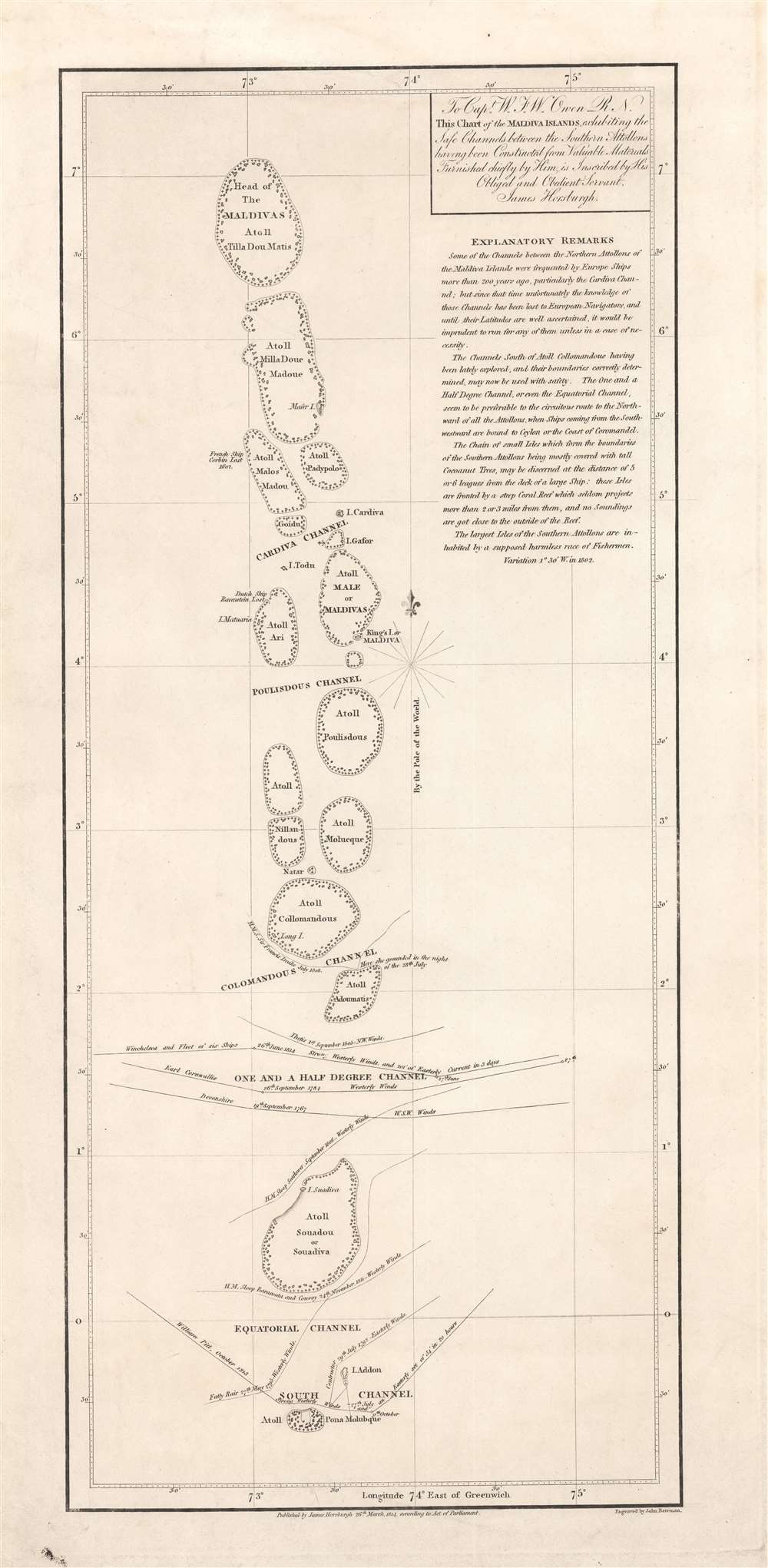
To Capt. W.F.W. Owen R.N. this chart of the Maldiva Islands, exhibiting the safe channels between the southern attollons.
1814 (dated) 23.75 x 12 in (60.325 x 30.48 cm) 1 : 1800000
1814 (dated) 23.75 x 12 in (60.325 x 30.48 cm) 1 : 1800000
Description
This is a rare 1814 James Horsburgh nautical map of the central part of the Maldives or Maldivian Archipelago around Malé. Although seemingly simplistic, Horsburgh's chart marks a major advance in Europeans' geographical and hydrological knowledge of the archipelago. The dangerous, near impassible reefs, had long served as the archipelago's most effective and only line of defense against foreign imperialistic interests. This chart partially opened the islands to foreign navigation and marked the beginning of a long period of European influence. This Horsburgh chart served as the definitive mapping of the Maldives until the Robert Moresby surveys of 1834 - 1836.
Horsburgh's chart recommends safe routes through the waters of the southern atolls and notes the routes taken by earlier British ships, including Owen's own ship, the Seaflower. It also records the strong winds that ships encountered, places where they ran aground, and where French and Dutch ships had sunk.
Horsburgh's chart follows on the work of Johannes van Keulen and Alexander Dalrymple, his predecessor as the Hydrographer of the East India Company. Nevertheless, this chart was a major advance in its specificity and its navigational information.
Through nearly 2500 years of history, the Maldives were an important independent kingdom and stopping point for the Indian Ocean trade. Today, the archipelago is the world's most at-risk nation from Global Warming. With an average elevation of just 5 meters, it is estimated that sea level rise will make the Maldives uninhabitable by 2050. The government is attempting to shore up the larger islands, but this effort will ultimately not save the more than 200 inhabitable islands. Other efforts include purchasing vast tracks of land in India, Sri Lanka, and Australia, where the Maldivian people plan to establish a nation in exile.
Historical Context
The map is addressed to Royal Navy officer William Fitzwilliam Owen, who explored the Maldives in 1806 and whose notes Horsburgh consulted. Explanatory text describes how Europeans travelled to the islands some 200 years earlier but that their navigational knowledge had been lost. The Portuguese arrived in 1558 and established a trading post, but alienated the local populace by imposing Christianity, and were thusly overthrown in 1585. Later, in the mid 17th century, the Dutch briefly occupied the Maldives, but ceded control to the British after they were expelled from nearby Ceylon.Horsburgh's chart recommends safe routes through the waters of the southern atolls and notes the routes taken by earlier British ships, including Owen's own ship, the Seaflower. It also records the strong winds that ships encountered, places where they ran aground, and where French and Dutch ships had sunk.
Horsburgh's chart follows on the work of Johannes van Keulen and Alexander Dalrymple, his predecessor as the Hydrographer of the East India Company. Nevertheless, this chart was a major advance in its specificity and its navigational information.
The Maldivian Archipelago
The Republic of Maldives, corresponding to the archipelago consisting of nearly 1,200 islands grouped into twenty-six atolls, stretches across 35,000 square miles yet is one of the smallest countries by population in Asia, second only to Brunei. The capital Malé has historically been the seat of political power and is the basis for the toponym 'Maldive'. Although the islands sparsely populated, Malé is home to the majority of the population and is one of the world's most densely populated cities.A Tragic End for the Maldives
Settlement on the Maldives can be traced to about 500 BC, when the archipelago was settled by the Dheyvi Peoples, from Kalibanga, India. The Maldives was subsequently established as a Hindu then Buddhist Kingdom lasting some 1,400 years. In 1153, the Buddhist King of the Maldives converted to Islam, adopting the Muslim title of Sultan Muhammad al-Adil. The Sultanate of the Maldives lasted until 1932, when it became a constitutional monarchy. The monarchy fully ended by 1969, when the Maldives became a republic.Through nearly 2500 years of history, the Maldives were an important independent kingdom and stopping point for the Indian Ocean trade. Today, the archipelago is the world's most at-risk nation from Global Warming. With an average elevation of just 5 meters, it is estimated that sea level rise will make the Maldives uninhabitable by 2050. The government is attempting to shore up the larger islands, but this effort will ultimately not save the more than 200 inhabitable islands. Other efforts include purchasing vast tracks of land in India, Sri Lanka, and Australia, where the Maldivian people plan to establish a nation in exile.
Publication History and Census
This chart was published by Horsburgh in March 1814 'according to Act of Parliament' and engraved by John Bateman. At this time, Horsburgh was near the start of a long tenure as the Hydrographer of the East India Company. The chart is very rare, with only one other known example existing in the collections of Harvard University.CartographerS
James Horsburgh (September 28, 1762 – May 14, 1836) was a Scottish hydrographer and navigator active in the late 18th and early 19th century. Horsburgh was born in Fife, Elie, Scotland, to a humble family. Like many young Scottish men of little means, Horsburgh was destined for a sea-faring life and at just 16 signed on as a cabin boy in a coal trading ship. After many misadventures, including a brief incarceration by the French at Dunkirk, Horsburgh made his way to the West Indies and eventually to Calcutta, India. As the center for British maritime trade in the region, Horsburgh had no difficulty finding work with the British East India Company who maintained an active trade network between India and China. Despite the regular trade, one these voyages to China, aboard the ironically named Atlas, taught Horsburgh just how poorly the East Indies were charted. The 1786 shipwreck of the Atlas, on which he was the First Mate, near Diego Garcia Island proved a pivotal moment Horsburgh's life. He subsequently devoted himself to accurately charting the Indian Ocean and the dangerous Straits of Malacca, Sunda, and Singapore. Many of Horsburgh's charts are the direct results of his own unique survey work on board the Carron and later as captain of the Anna. Horsburgh's work culminated in the publication if his 1809 Directions for Sailing to and from the East Indies, China, New Holland, Cape of Good Hope, and the Interjacent Ports, a monumentally important guide to navigating the waters of the Indian Ocean and the East Indies. His work earned him friendships in London's highest naval and scientific circles, among them Joseph Banks and Alexander Dalrymple. He became a member of the Royal Society in 1806, when he retired from active sailing. When Alexander Dalrymple died in 1810, Horsburgh was appointed to the prestigious position of Hydrographer to the British East India Company where he worked until his death in 1836. Whereas Dalrymple was somewhat indiscriminate regarding the charts he published, Horsburgh was exacting and double checked the veracity of each and every chart that passed through his office. Horsburgh's work with the East India Company elevated the standards of the Hydrographic Department and earned him a Fellowship with the Royal Society. Today's Horsburgh's accomplishments are memorialized by the Horsburgh Lighthouse, near Singapore, and Horsburgh Island. When Horsburgh died most of his work was passed by his children to the Admiralty, which continued to publish updates until roughly 1864. More by this mapmaker...
John Bateman (fl. 1804 – 1825) was a British copperplate printer, map, and chart engraver active in London during the early part of the 19th century. Bateman is best known for his maps and charts, especially of the East Indies engraved for James Horsburgh and published between 1804 and 1825. He appears to have spent time in the East Indies with records documenting him in Calcutta as early in 1799 and may have befriended Horsburgh there. Some have speculated that John Bateman is related to Richard Bateman, another map and chart engraver active during roughly the same period. Learn More...
William Fitzwilliam Owen (September 17, 1774 - November 3, 1857) was an officer in the British navy and a renowned explorer. He embarked on the HMS Culloden as a midshipman at the age of 13 and began his life in the navy. He served under Lord Nelson during the first years of the Napoleonic Wars. In 1803, when war with France resumed, he was given command of the 16-gun brig HMS Safflower and sent to the East Indies, where he would spend the next few years. He explored the Maldives in 1806 and discovered the Seaflower Channel, which is between the islands of Siberut and Sipora off the west coast of Sumatra, that same year. In 1808 he was captured by the French and imprisoned in Mauritius for two years. he returned to England in 1813 and spent from 1815 to 1816 surveying the Canadian Great Lakes.
Between 1821 and 1826, Owen mapped the entire east coast of Africa from the Cape of Good Hope to the Horn of Africa in the sloop Leven. He returned in 1826 with 300 new charts which covered 30,000 miles of coastline, but over half of the original crew had died of tropical diseases. In the mid-1830s, nearing the end of his career, Owen moved his family to New Brunswick, where he became involved in local politics and even served as a justice of the peace. In the final action of his career in the Navy, Owen conducted the definitive survey of the Bay of Fundy between September 1842 and December 1847. Some charts in use today are based on his work. Learn More...
Condition
Very good. Slight dampstaining in upper margin.
References
Harvard Map Collection, HOLLIS 990126346290203941. OCLC 1252336369.