
1595 Ortelius Map of Mansfeld and Environs, Saonxy-Anhalt, Germany

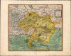
Mansfeldiae Comitatus Descriptio.
Stronghold of Lutheranism.
- Digital Map Information
- Suitable for large format printing
- Full resolution TIFF file
- ICC color profile embedded
- Delivered instantly via download link
Stronghold of Lutheranism.
This is an old-color 1595 map of the town of Mansfeld in central Germany and its environs, published in Abraham Ortelius' Theatrum Orbis Terrarum. It depicts the region after the early decades of the Protestant Reformation and the establishment of Lutheranism, whose founding figure was born and raised here.A Closer Look
The map covers the area around Mansfeld from the River Bode at top-left to Bernberg and Prost at top-right and from the River Helbe at bottom-left to Kirchscheidungen at bottom-right. Most towns are shaded red for easy distinction, while surrounding Saxony and Thuringia are also color-shaded in addition to the County of Mansfeld itself. Villages, forests, and waterways are illustrated and labelled.The bodies of water at right are worth commenting upon. While the Susser See remains today, the nearby Glalssen See no longer does. This body of water, also called by Ortelius the 'Gesaltzen' on the verso and later known as the Salziger See, was well known for its high salinity. Though this offered potential as a spa destination, the lake was drained in the 1890s by local mining companies to prevent the lake's floodwaters from threatening nearby mineshafts. In recent years, the state government of Saxony-Anhalt has attempted to reestablish the lake and create a large nature preserve to rebuild the ecosystem lost when the lake was drained. Ortelius relates some tall tales related to the 'Gesaltzen See' on the verso: 'if fishermen cast their nets deeply into it, they will immediately be singed and scorched as if they had been burnt or dragged through a fire.'
Stronghold of Lutheranism
Mansfeld was known, even renowned among Lutherans, around the time this map was produced because of its importance for the life and family history of Martin Luther (1483 - 1546). At the time, Mansfeld maintained town status and immediacy (until 1580) within the Holy Roman Empire, meaning it had considerable autonomy despite its small size. It was also prosperous due to nearby copper and silver mines. These attracted master smelter Hans Luder, the father of Martin Luther, to move to Mansfeld with his family in 1484. Though born in nearby Eisleben, Martin Luther spent his childhood in Mansfeld, where his father became a prominent citizen. As a result of his ties to Mansfeld and the nearby town of Eisleben, this area became a stronghold of Lutheranism in the early years of the Protestant Reformation.Publication History and Census
This map was engraved by Franz Hogenberg and published by Abraham Ortelius in the 1595 Latin edition of the Theatrum Orbis Terrarum, of which 500 Copies were printed. Ortelius' map is based on an earlier one by the mathematician and cartographer Tilemann Stella, who was enlisted by the Counts of Mansfeld to survey their territory. It appeared in the Theatrum between 1573 and 1609, and in its various printings is well-represented in institutional collections and occasionally appears on the market. That being said, the present edition is only independently cataloged in the OCLC among the holdings of the Duchess Anna Amalia Library in Weimar and the Universitäts- und Landesbibliothek Sachsen-Anhalt.Cartographers
Abraham Ortelius (April 14, 1527 - June 28, 1598) also known as Ortels, was a cartographer, geographer, and cosmographer of Brabant, active in Antwerp. He was the creator of the first modern atlas, Theatrum Orbis Terrarum and is a seminal figure in the history of cartography. Along with Gerard Mercator and Gemma Frisius, he was a founder of the Netherlandish school of cartography. His connections with Spain - culminating in his 1575 appointment as Royal Cartographer to King Phillip II of Spain - gave him unmatched access to Spanish geographical knowledge during a crucial period of the Age of Discovery. Ortelius was born in 1527 in Antwerp. In 1547 he entered the Antwerp Guild of Saint Luke as an illuminator of maps. He began trading in books, prints, and maps, traveling regularly to the Frankfurt book and print fair, where in 1554 he met Mercator. He accompanied Mercator on journeys throughout France in 1560 and it was at this time, under Mercator's influence, that he appears to have chosen his career as a scientific geographer. His first published geographic work appeared in 1564, an eight-sheet cordiform world map. A handful of other maps preceded the 1570 publication of the first edition of the Theatrum Orbis Terrarum, which would prove to be his life work. Appearing with but 53 maps in its first edition, Ortelius' work expanded with new maps added regularly. By 1592, it had 134 maps. Many of Ortelius' maps remained the standard for nearly a century. He traveled extensively, but his genius was as a compiler, locating the best informed maps on which to base his own. His contacts throughout Europe and extending even (via the Portuguese) to the Far East were formidable. Moreover, many of his maps were based on his own scholarship, particularly his historical works. His theories of geography were particularly ahead of his time with respect to the notion of continental drift, the possibility of which he mused on as early as 1596, and which would be proven correct centuries later. In a sense his greatest achievement was his successful navigation of the religious and political violence endemic to his city throughout his adult life: The Dutch Revolt, or Eighty Years' War (1568 - 1648), fully embroiled Antwerp. Although outwardly and officially recognized as Catholic (Arias Montanus vouched for Ortelius' Catholic orthodoxy prior to his appointment as Royal Geographer), Ortelius was able to separate himself from the religious furor which characterized the war in the low countries. Ortelius showed a glimpse of himself in a letter to a friend, regarding humanist Justus Lipsius: 'I do not know whether he is an adherent of the Pope or a Calvinist, but if he has ears to hear, he will neither be one nor the other, for sins are committed on both sides'. Ortelius' own explorations of Biblical history in his maps, and the Christogram contained in his own motto, suggest him to be a religious man, but his abjuration of political religious authorities mark him as an individualist. His tombstone at St Michael's Præmonstratensian Abbey in Antwerp bears the inscription, Quietis cultor sine lite, uxore, prole. ('served quietly, without accusation, wife, and offspring.') Further Details...
Franz Hogenberg (1535 - 1590), often called 'Master Franz,' was a Flemish engraver active in the late 16th century. Hogenberg was born in Mechelen, the son of Nicolas Hogenberg, where he trained under the cartographer H. Terbruggen. He later relocated to Antwerp where he achieved success as an engraver, working with Abraham Ortelius, Hieronymus Cock, and others. In 1568, his name appeared on the list of those banned from the Netherlands by the Duke of Alva, forcing his family to flee to London. There he engraved for Christopher Saxon's Atlas of England and Wales. By 1570 he emigrated to Germany settling in Cologne. In Cologne he married his second wife, Agnes Lomar, with whom he had six children. In 1579 the couple were briefly imprisoned for holding illicit secret religious meetings, but were released in short order. Along with German cleric George Braun (1541 – March 10, 1622), Hogenberg issued the highly influential city atlas Civitates Orbis Terrarum. The six volume work, with some 546 views, was published between 1572 and 1617 and intended a companion to Abraham Ortelius' Thatrum Orbis Terrarum - thus certain obvious stylistic similarities. In compiling the Civitates Hogenberg took on the role of engraver while most of the editing was left to Georg Braun. Hogenberg died in Cologne, Germany, before the Civitates was completed. After his death, Hogenberg's work was continued by his son, Abraham Hogenberg, who, under the direction of Agnes, his mother, took over his father's enterprise at just 20. Further Details...
Source
Ortelius, A., Theatrum Orbis Terrarum, (Antwerp: Plantin) 1595.
Abraham Ortelius' magnum opus, Theatrum Orbis Terrarum, was the world's first regularly produced atlas, which 'set the standards for later atlases ... It was the first undertaking of its kind to reduce the best available maps to an uniform format.' (Koeman) A modestly-sized work of fifty-three maps in its first edition of May 1570, it was an immediate success: there were three further editions that year, and the work remained in print for a total of 32 editions, the last of which was 1641, well after its author's 1598 death. Ortelius added to his atlas constantly, and by 1595 the Theatrum contained 147 maps. Ortelius is renowned generally as an editor, and indeed much of the Theatrum is compiled from a variety of sources: in such cases, Ortelius was scrupulous in naming his sources. But Ortelius was also a mapmaker in his own right: many of his maps are a distillation of various sources into his own work, and there were many maps - particularly in his atlas of Biblical and ancient history Parergon - which were entirely Ortelius' work. In his role as an editor, Ortelius followed in the footsteps of Munster, whose Cosmographia was, until Ortelius, the best window on the world for the curious European reader. In terms of the artistry of his maps, Ortelius oversaw the first great flourishing of copperplate engraving in the service of cartography to occur in Northern Europe. Ortelius' work provided the model for the atlases of Mercator, Hondius, Blaeu and all their progeny in the 17th century - many of whom were to produce faithful editions of Ortelius' maps in their own productions.
Condition
Very good. Light toning along centerfold.
References
OCLC 551925310.