
1953 Pacific Stars and Stripes Map of the Korean War

This item has been sold.
Pacific Stars and Stripes Map of the War.
Patriotic map of the Korean War.
Choose a Collection:
- Digital Map Information
- Suitable for large format printing
- Full resolution TIFF file
- ICC color profile embedded
- Delivered instantly via download link
This Item
Enquire
Patriotic map of the Korean War.
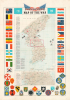
This is a 1953 Pacific Stars and Stripes map of the Korean War (1950 - 1953). It depicts the Korean Peninsula near the 'end' of the conflict, which had reached a stalemate and resulted in a ceasefire in July 1953, three years and one month after North Korea's initial invasion of the South.A Closer Look
The map depicts the Korean peninsula from the Yalu River and the Tumen River to the Korea Strait and from the Yellow Sea to the Sea of Japan. 25 Korean War events are numbered, with explanations along the left border. Aircraft silhouettes overlaying the image include a Grumman F9F Panther, a squadron of large four-engine bombers over the Sea of Japan, and a red MiG-15. An inset map, situated below the central map, details the boxed area in the main map, along the 38th parallel from Yonan and Panmunjom to Kansong. Strategically located hills and ridges, many the sites of major battles, are labeled: Punchbowl, Bloody Ridge, Heartbreak Ridge, and Christmas Hill, and the Iron Triangle. The map is bordered on three sides by the flags of the United Nations, and the insignia of American combat units are included along the bottom border.The Later Stages of 'the Forgotten War'
This map was issued near the end of the Korean War (the inset map is dated March 19, 1953), which resulted in a frozen frontline that evolved into the current Demilitarized Zone. The Korean War was the first 'hot' war of the Cold War, which left the country divided and devastated. Despite a dynamic first year, by the summer of 1951, the war had settled into a stalemate around the original dividing line at the 38th parallel north. Armistice negotiations began in July 1951 but dragged on for months as neither side wanted to end the war without at least recovering their full prewar territory. The war exhausted the major outside powers engaged - the U.S. and the People's Republic of China - and became a major political liability for President Harry Truman.The archival record indicates that both Koreas and China were resistant to an armistice for much of this period, with the Chinese thinking they could outlast the Americans and get a better agreement later. The U.S. and North Korea/China were also bitterly divided over the issue of returning prisoners of war, mostly because the U.S. had offered Chinese prisoners the option of going to Taiwan and North Korean prisoners the option to remain in South Korea. In any event, in the weeks after Stalin's death on March 5, 1953, the new Soviet leadership pushed both Mao Zedong and Kim Il-sung to agree to an armistice and focus on reconstruction. An armistice agreement was signed on July 27, 1953, but the conflict never formally ended.
Publication History and Census
This map was published by Pacific Stars and Stripes in 1953 and printed by the Kyoya Company of Tokyo (株式会社京屋). This is not the department store supply company that still operates under the name Kyoya. A 1952 map of the same title was also issued by Pacific Stars and Stripes (Korea-pacific-1952), but it differs considerably in appearance. Two examples of the present map are cataloged in OCLC, one at the Wisconsin Veterans Museum Research Center and the other at Stanford University (David Rumsey Historical Map Collection).Cartographer
Stars and Stripes, Pacific Editions (1945-1963) began publishing the week of VE Day in May, 1945 in Honolulu, Hawaii. Later that year editions were published in China and Japan as well. When the war ended, the newspaper’s readership and staff both fell, although it was still published for occupational forces and other armed forces still employed. In 1951, during the Korean War, a Korean edition was published. Further Details...
Condition
Very good. Slight foxing.
References
OCLC 953572675. Rumsey 7848.000.