
1947 Carriat-Rolant Bilingual Pictorial Map of Morocco

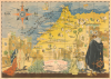
Maroc sous le regne de S.M. Mohammed V / المغرب الأقصى خريطة الإيالة الشريفة أيام سلطنة سيدي محمد الخامس.
Last Stage of the French Protectorate in Morocco.
- Digital Map Information
- Suitable for large format printing
- Full resolution TIFF file
- ICC color profile embedded
- Delivered instantly via download link
Last Stage of the French Protectorate in Morocco.
This is a rare c. 1947 Gabriel Carriat-Rolant bilingual French and Arabic pictorial map of Morocco - issued to promote tourism. At the time, Morocco was divided into three administrative zones: protectorates managed by France and Spain, respectively, and the remarkable, cosmopolitan Tangier International Zone.A Closer Look
The map covers Morocco between Oujda and Agadir, excluding the Spanish protectorate over southern Morocco, which includes part of today's long-disputed territory of Western Sahara. The French and Spanish zones are not indicated to maintain the pretense of Moroccan independence under Sultan Mohammed V (r. 1927 - 1961, first as Sultan and then as King). Cities and large towns are labeled in both French and Arabic, with the skylines of larger cities such as Marrakesh, Fes, Casablanca, and Tangier illustrated. Within and surrounding the map are colorful illustrations, mostly of local Moroccans engaged in various daily activities. On the water are illustrations of ships and a decorative compass rose.Historical Context
This map depicts Morocco when it was partitioned into three territorial spheres - French and Spanish Protectorates and the international zone of Tangier. After several years of imperial competition between the French and Spanish, the Treaty of Fes, signed on March 30, 1912, compelled Sultan Abdelhafid (of the Alawi or Sharifian Sultanate) to accept a French protectorate over most of Moroccan territory. To appease Spanish colonial ambitions and satisfy British desires for a strategic buffer zone opposite Gibraltar, France later that year signed a separate agreement with Spain. This treaty carved out a Spanish Protectorate in the rugged northern Rif region and the southern strip of Tarfaya, effectively fracturing Morocco into distinct zones of European administrative and military control.While France and Spain divided the bulk of the Moroccan mainland, the strategic port city of Tangier required a unique diplomatic compromise due to its position commanding the entrance to the Mediterranean. Unwilling to allow any single European power to control this vital maritime gateway, Britain, France, and Spain negotiated a multilateral administrative framework. This resulted in the Tangier Protocol of 1923, which officially established the Tangier International Zone in 1925. Governed by an international legislative assembly representing several European nations (and later the United States), Tangier became a highly cosmopolitan, duty-free enclave, similar to Shanghai and other treaty ports in East Asia. It operated as a unique hub for global commerce, espionage, and cultural pluralism, remaining politically isolated from the rest of colonized Morocco until the country regained its independence and unity in 1956. As elsewhere in Africa and throughout the world, European colonial rule in Morocco, already under threat in the Interwar period, faced outright revolt in the Postwar period.
Publication History and Census
This map was drawn by Gabriel Carriat-Rolant, printed by the local printer Gaillard (presumably a French colon), and published by the Agence française de représentation et d'impressions publicitaires (AFRIP), a seemingly semi-official body that produced maps and posters for the protectorate. There are at least two editions: an 'Edition originale' in French only, printed in a limited run of 1,000 numbered prints, and this bilingual edition, printed in an unknown quantity but seemingly rarer. The French edition is dated to 1947, resulting in the date ascribed here. The French edition is cataloged at the Newberry Library and the Bibliothèque Nationale du Royaume du Maroc, but we have not located any cataloged examples of this bilingual edition.Cartographers
Gabriel Carriat-Rolant (fl. c. 1935 - 1955) was a French painter and artist known for his colorful gouache Orientalist works. Details of his life are murky and minimal, but he appears to have emigrated to Morocco in the early-mid 1930s and producing distinctive works, which mostly related to the scenery and culture of North Africa. He is known to have produced at least three pictorial maps - one of French West Africa, one of Morocco, and one of Corsica. Further Details...
Imprimerie Gaillard Maroc (c. 1947 - present) is a printer based in Casablanca, Morocco, which at times maintained outposts in other cities, especially Rabat. The firm was most active in the last years of the French protectorate in Morocco, producing tourist guides and related works (mostly in French but sometimes in Arabic, German, or other languages), often for the government itself. Remarkably, the company still appears to be in operation, though it presumably has shifted to other types of publishing as their books and guides disappear from library catalogs from the late 1950s onwards. Further Details...
Condition
Good. Some fading. Minor closed and repaired margin tear, right side, extending to border.
References
French Edition - OCLC 1589263263, 929536325.