
This item below is out of stock, but another example (left) is available. To view the available item, click "Details."
Details
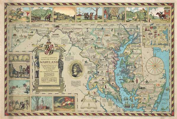
1931 Edwin Tunis Historical Pictorial Map of Maryland
1931 (dated) $850.00
1931 Edwin Tunis Historical Pictorial Map of Maryland
Maryland-tunis-1931$425.00

Title
An Historical and Literary map of the Old Line State of Maryland Showing forth divers curious and notable facts relating to scenes, incidents and persons worthy to be recalled on the state's three hundredth anniversary.
1931 (dated) 26 x 39 in (66.04 x 99.06 cm) 1 : 430000
1931 (dated) 26 x 39 in (66.04 x 99.06 cm) 1 : 430000
Description
Issued during the Golden Age of American Pictorial Maps (c. 1920 - 1960), this wonderful 1931 first edition historical and pictorial map of Maryland was the first map issued by Edwin Burdette Tunis. The map covers all Maryland, including the Chesapeake Bay in full, as well as adjacent parts of Delaware and Virginia. Published in conjunction with the Enoch Pratt Free Library, this type of Pictorial map is a naturical extension of Tunis' meticulous attention to historical detail. Copious annotations throughout describe historical personages, locations, battles, and buildings as well as expounding upon the general historical progression of the region. Vignettes above and to the left of the map proper illustrate the Battle of Long Islands, the opening of the Chesapeake and Ohio Canal, the construction of Fort Frederick, the purchase of St. Mary's by Leonard Calvert from indigenous American Indian tribes, and more. An inset in the upper left details Annapolis and the U.S. Naval Academy.
This map was lithographed in color by A. Hoen and Company of Baltimore, Maryland. There are two editions, the first published in 1931, as here, and a second reissued by the Enoch Pratt Free Library in 1956.
This map was lithographed in color by A. Hoen and Company of Baltimore, Maryland. There are two editions, the first published in 1931, as here, and a second reissued by the Enoch Pratt Free Library in 1956.
CartographerS
Edwin Burdette Tunis (December 8, 1897 - 1973) was an American painter, mural artist, illustrator, radio announcer, actor, theater set designer, and author active in Maryland during the middle part of the 20th century. Tunis was born in Cold Spring Harbor, New York, but moved around a lot a child with his father's work, before settling as an adult in Maryland. Tunis is known for his meticulous attention to historical detail and the production of several illustrated volumes describing various aspects colonial and pioneer life. Although he made few pictorial maps, they genre was a natural extension of his historically driven style. His first and best map, of Maryland, was published in 1931. He also issued maps of Baltimore, the Chesapeake Bay, and York County Pennsylvania. More by this mapmaker...
August Hoen and Company (fl. c. 1840 - 1981) was a Baltimore based engraving and lithography firm active in the middle part of the 19th century. A. Hoen and Co. was originally founded by Edward Weber under the name 'E. Weber and Company.' Weber died in the early 1850s and his company was taken over by German immigrant August Hoen (18?? - 1886) and his brothers, Henry and Ernest Hoen. As general interest lithographers, the Hoen firm's corpus includes posters, cigar boxes, sheet music covers, and posters as well as maps. They are best known for their pioneering multi-color lithographic techniques. After the death of August Hoen, the business passed on to his son, Albert Hoen. Another son, Earnest A. Hoen, moved to Richmond, Virginia and opened a branch of the firm there where he was granted a charter to produce Civil War era Confederate Currency. Their contributions to the cartographic field are generally in association with engraving and printing work done for Jacob Monk and the U.S. Geological Survey. The Hoen family maintained an active interest in the firm for the next 100 years or so until it finally filed for bankruptcy in 1981. Learn More...
Condition
Very good. Minor toning and creasing. Light foxing. Light soiling lower left corner.
References
Rumsey 8334.000. OCLC 29233572. Hornsby, S. J., Picturing America: The Golden Age of Pictorial Maps, page 170, plate 82.