
1948 Survey of Egypt Arabic-Language Map of Mecca (Makkah)


This item has been sold.
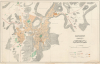
المملكة العربية السعودية (الأقطار الحجازية) مدينة مكة المكرمة / [The Kingdom of Saudi Arabia (Hejaz Territories) the Holy City of Mecca].
House of Saud's Modernization of Mecca.
- Digital Map Information
- Suitable for large format printing
- File Size: 38.6 MB
- File Type: ZIP / TIFF
- ICC color profile embedded
- Delivered instantly via download link
House of Saud's Modernization of Mecca.
A remarkable find; this scarce, large-format Arabic-language map of the holy city of Mecca was prepared in 1948 by the Survey of Egypt. This map reflects an effort by the House of Saud to mark their rule over the Hejaz and the holy sites therein by making Mecca more accessible to Muslim pilgrims.A Closer Look
Mecca is displayed, with religious sites and the city color-shaded between the surrounding hills and mountains. The legend notes cultivated land and gardens (green), water tanks and wells (blue), and government buildings (orange). Cemeteries, areas of housing, roads, mosques, wireless and telephone communications, and valleys are also indicated according to symbols in the legend at bottom-right. Land subdivided for future construction is ghosted in at top-left, including a planned hospital. Elevations are noted throughout, especially in the valley at right (al-Maabdah).The Great Mosque of Mecca (Masjid al-Haram) is prominent at middle towards left, noted by the Kaaba (ٱلْكَعْبَة). Other important sites are noted, such as the al-Muallaa Cemetery (مقبرة المعلاة) and the al-Maabadah Royal Palace (قصر المعابدة الملكي, also known as the al-Saqqaf Palace قصر السقاف), now known as the King Abdulaziz Palace. The palace became an important site for King Abdulaziz (Ibn Saud), the founder of Saudi Arabia, soon after his forces captured Mecca in late 1924, and it has served in multiple roles for the House of Saud and the Saudi government since.
Modernizing Mecca
This map reflects an effort by the Saudi government to mark their rule over the Hejaz and the holy sites therein by making Mecca more accessible to Muslims from throughout the world. Multiple projects were launched to build or upgrade roads, install water systems, and build accommodations for Hajj pilgrims (efforts that were greatly aided by the tremendous wealth acquired by the kingdom's exploitation of oil reserves). An entire government ministry (the Ministry of Hajj and Umrah) was established to oversee pilgrims' travel, accommodations, health, safety, and religious matters. As a result, Mecca has grown considerably since the mid-20th century, gobbling up previously distinct towns and nearby cities. However, one casualty of these modernization efforts was much of the historic city of Mecca outside of the religious sites. In recent years, even more impressive modernization efforts have been undertaken, including a high-speed rail (the Haramain High Speed Railway) linking Mecca with Medina via Jeddah, with a link to the King Abdulaziz International Airport, which handles international travel to Mecca, especially during the Hajj.Publication History and Census
This map was prepared by the Survey of Egypt (مصلحة المساحة المصرية) in 1948. There are three editions of the map, with the first two (1945, 1947) only held by the Library of Congress and Qatar National University, though at least some of the Library of Congress holdings are noted as photocopies in their catalog. The map appears to be related to a series of maps of Mecca and nearby cities dealing with various issues related to urban planning (see Library of Congress catalog listing for G7534.H4 s100.E3, LCCN 2011591873; also see our contemporary Survey of Egypt maps of Madinah, Madinah-surveyofegypt-1946, and Jeddah, Jeddah-egyptiansurvey-1945). The present third edition of the map is only noted among the holdings of Umm Al-Qura University at the Institute of Hajj and Umrah Research.Cartographer
Survey of Egypt (c. 1898 - present; مصلحة المساحة المصرية) was the official surveying body of the Egyptian government from the turn of the 20th century until the founding of the Republic of Egypt. As Egypt was a British Protectorate for most of this period, the survey closely resembled government survey operations in other British colonies and protectorates. However, unlike many other surveys, the Survey of Egypt did not continue under its colonial name in the postcolonial period. Instead, in the independence era, the former Survey became known as the Egyptian General Survey Authority (الهيئة المصرية العامة للمساحة), from 1971 has been affiliated with the Ministry of Irrigation (وزارة الري). Further Details...
Condition
Good. A few minor repairs on verso. Dampstain lower right corner, with some loss to imprint.
References
Umm Al-Qura University Institute of Hajj and Umrah Research Call No. 912.53121 AH.