This item has been sold, but you can get on the Waitlist to be notified if another example becomes available, or purchase a digital scan.
1844 Perrot Chart or Map of Weather Phenomena
Meteorology-perrot-1844$925.00

Title
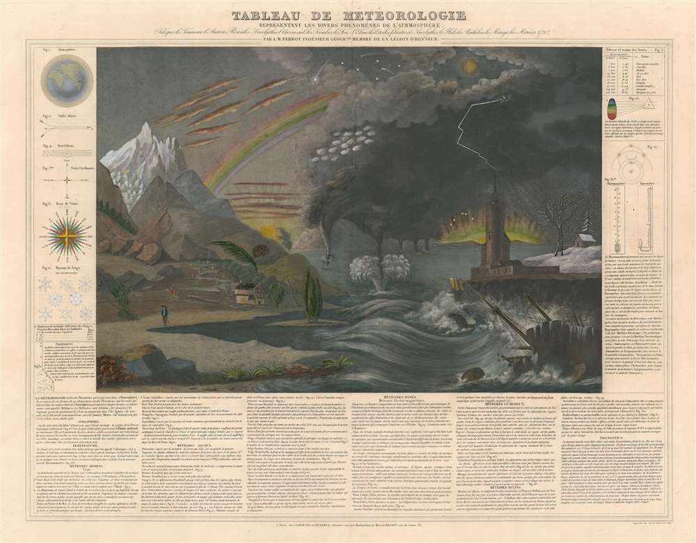
Tableau de Météorologie Représentant les Divers Phénomènes de l'Atmosphère, Tels que le Tonnere, l'Aurore Boréale, Aréolythes, l'Arc-en-ciel, les Trombes, le Feu St. Elme, les Etoiles filantes et Aréolythes, le Halo, les Parhélies, le Mirage, les Marées, etc., etc.
1844 (undated) 20.5 x 25.5 in (52.07 x 64.77 cm)
1844 (undated) 20.5 x 25.5 in (52.07 x 64.77 cm)
Description
This is an 1844 Aristide Michel Perrot chart of weather phenomena. The chart combines illustrations of over two dozen different weather phenomena, including lightning, tornadoes, rainbows, the Northern Lights, and clouds. Different phenomena are identified below the central image, with the name of each phenomenon and a short explanation provided, some of which even refer to a specific part of the central image and provide the corresponding number. Various figures are included along the left and right borders, the first of which, the atmosphere, is provided as a basis for understanding of all the phenomena explained in the chart. A wind compass, snowflakes, and a lightning rod are depicted along the left side, while thermometers and the rainbow effect are explained along the right.
Publication History and Census
This chart was created by Aristide Michel Perrot and published by the Langlois and Leclercq firm and the Basset firm in 1844. This chart is not catalogued in the OCLC and is extremely rare on the private market.CartographerS
Aristide Michel Perrot (1793 - 1879) was a French geographer, cartographer, and essayist active during the 19th century. Perrot specialized in miniature maps that appear in numerous French atlases. Perrot was also a prolific writer and his works include geographic lexicons and several essays. More by this mapmaker...
André Basset (Bassett; fl. 1768 - 1784) was a well-known French publisher and engraver active on the Rue St. Jacques, Paris, during the 18th and 19th centuries. His office was located at the corner of Rue Saint Jacques and of Mathurins, à l'enseigne de Sainte Geneviève. The firm is closely aligned with the Chéreau family of printers and engravers, with whom they were connected with multiple, often incestuous, marriages and remarriages. Basset was best known for the production of low-cost optical views of European cities and events. However, the firm also produced games, maps, and other prints. The firm was taken over by Paul-André Bassett (1759 - 1829) in 1784. Paul-André Bassett himself retired in 1819, but the business continued under various family members until 1865. Learn More...
Condition
Very good. Even overall toning. Blank on verso.