1722 Covens and Mortier / De l'Isle's Foundational Map of Mexico and the Mississippi
Mexico-delisle-1722-2$1,400.00
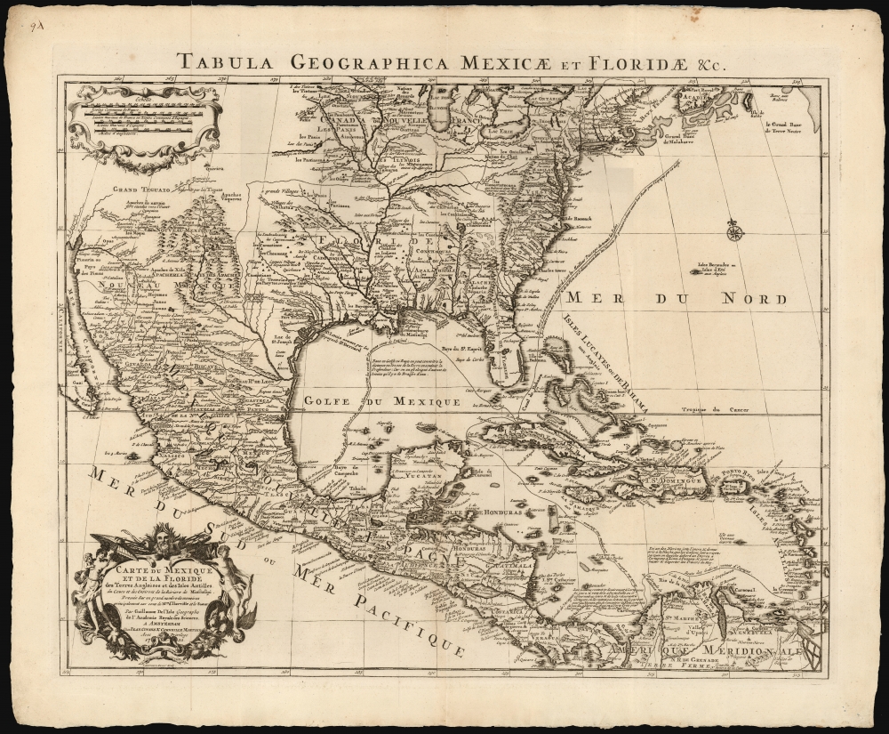

Title
Carte du Mexique et de la Floride des Terres Angloises et des Isles Antilles... / Tabula Geographica Mexicae et Floridae etc.
1722 (dated) 19 x 23.5 in (48.26 x 59.69 cm) 1 : 9000000
1722 (dated) 19 x 23.5 in (48.26 x 59.69 cm) 1 : 9000000
Description
This is the 1722 Covens and Mortier issue of Guillaume de L'Isle's groundbreaking map of North America, focusing on Mexico, the Mississippi watershed, and the West Indies. De L'Isle first published this map in 1703, at which point it was the most sophisticated map of the region obtainable: the first map to accurately denote the course of the Mississippi River, the first to accurately place the Great Lakes, and the first appearance on a map of updates from La Salle, Bienville, and D'Iberville.
Covens and Mortier Edition
The Parisian De l'Isle, having already reissued the map in France, contracted Amsterdam publishers Covens and Mortier to produce this edition, one of the few authorized variants of this often-copied map. This Amsterdam edition was expertly engraved to a new plate by Jan Heeren Stemmen, one of Covens and Mortier's primary engravers.Teguayo
The territories assigned Mexico here, of course, extend far to the north (indeed, continuing off the map). The detail includes New Mexico's missions along the Rio Del Norte, including Taos and Santa Fe. Beyond the narrow valley attached to the Rio de Norte, however, the region is only tenuously mapped. The mythical Kingdoms of Gold, Quivara and Teguayo, are noted just under the scale cartouche. The empire of Gran Teguayo appears in the unmapped region to the northwest of Santa Fe. Teguayo was identified as one of the Kingdoms of Gold presumed to be found in the unexplored American west. The name Teguayo first appears in the Benevides Memorial, where it is described as a kingdom of great wealth to rival Quivara, another supposed kingdom just north of Taos. The idea was later popularized in Europe by the nefarious Spaniard and deposed governor of New Mexico, Diego Dionisio de Peñalosa (1621 - 1687), who imagining himself a later day Pizzaro, promoted the Teguayo legend to the royalty of Europe. Originally, Teguayo was said to lie west of the Mississippi and north of the Gulf of Mexico, but for some reason, De L'Isle situates it further to the west.'Floride Francois'
The massive area marked out as 'Floride' here - including as it does the Mississippi watershed, on up to the New France and the Great Lakes - represents Floride Francois, the French claims dating to the mid-16th century that extended as far north along the Eastern Seaboard as modern day South Carolina.Publication History and Census
The basis for this map was published by Guillaume De l'Isle in 1703, thereafter to be widely copied. This authorized edition was engraved by Jan Stemmen in 1722 on behalf of Covens and Mortier to be included in their atlases, and it remained in print for much of the rest of the century. It is well represented in institutional collections.CartographerS
Guillaume De l’Isle (1675 - 1726) was a French cartographer, and arguably the finest mapmaker at the beginning of the eighteenth century. He was the son of Claude De L'Isle (1644 -1720), a Paris-based historian and geographer under Nicholas Sanson, then the leading light of French cartography. He was the chief proponent of the school of 'positive geography' and the primary figure defining the heights of the Golden Age of French Cartography. Guillaume's skill as a cartographer was so prodigious that he drew his first map at just nine years of age. He was tutored by J. D. Cassini in astronomy, science, mathematics and cartography. By applying these diverse disciplines to the vast stores of information provided by 18th century navigators, Guillaume created the technique that came to be known as 'scientific cartography', essentially an extension of Sanson's 'positive geography'. This revolutionary approach transformed the field of cartography and created a more accurate picture of the world. Among Guillaume's many firsts are the first naming of Texas, the first correct map of the Mississippi, the final rejection of the insular California fallacy, and the first identification of the correct longitudes of America. Stylistically De L'Isle also initiated important changes to the medium, eschewing the flamboyant Dutch style of the previous century in favor of a highly detailed yet still decorative approach that yielded map both beautiful and informative. Guillaume was elected to the French Academie Royale des Sciences at 27. Later, in 1718, he was also appointed 'Premier Geographe du Roi', an office created especially for him. De L'Isle personally financed the publication of most of his maps, hoping to make heavy royalties on their sales. Unfortunately he met an untimely death in 1728, leaving considerable debt and an impoverished child and widow. De L'Isle's publishing firm was taken over by his assistant, Phillipe Buache, who would also become his son in law. More by this mapmaker...
Covens and Mortier (1721 - c. 1862) was an Amsterdam publishing firm, the successor to the extensive publishing empire built by Pierre Mortier (1661 - 1711). Covens and Mortier maps are often criticized as derivative - but this is not fully the case. Pierre Mortier lived in Paris from 1681 to 1685. There he established close relationships the the greatest French cartographers of the era, including De L'Isle and D'Anville. His business model was based upon leveraging Dutch printing technology and sophistication to co-publish state of the art French cartography. Upon Mortier's death in 1711 his firm was taken over by his son, Cornelius Mortier (1699 - 1783). Cornelius married the sister of Johannes Covens (1697 - 1774) in 1721 and, partnering with his brother in law, established the Covens and Mortier firm. Under the Covens and Mortier imprint, Cornelius and Johannes continued in Pierre's model of publishing the most up-to-date French works with permission. They quickly became one of the largest and most prolific Dutch publishing concerns of the 18th century. The firm and its successors published thousands of maps over a 120 year period from 1721 to the mid-1800s. During their long lifespan the Covens and Mortier firm published as Covens and Mortier (1721 - 1778), J. Covens and Son (1778 - 94) and Mortier, Covens and Son (1794 - c. 1862). Learn More...
Jan Heeren Stemmen (1695 - 1734) was a Dutch engraver in Amsterdam whose work was published by the firms of Covens and Mortier, Bilhamer, Heyman van Dyck, and Ottens. No details of his early life or education have come down to us, though he appears to have been moderately successful: he married Jannetje de Hoonet at a young age, and is known to have fathered two children; a daughter, Anna in 1712 and a son Jan in 1716. Learn More...
Source
Covens and Mortier, Atlas nouveau, contenant toutes les parties du monde, (Amsterdam: Covens and Mortier) 1730.
Condition
Very good. Neat tack holes in corners well away from printed image, else excellent.
References
OCLC 9978665. Rumsey 4638.096. Wheat, C. I., Mapping of the Transmississippi West, 1540 – 1861, #84. Cumming, W., The Southeast in Early Maps, #137. Martin, J. C., and Martin, R. S.,Maps of Texas and the Southwest, 1513 - 1900, p. 92-3. Tooley, R. V., The Mapping of America, p. 22, #51.