This item has been sold, but you can get on the Waitlist to be notified if another example becomes available, or purchase a digital scan.
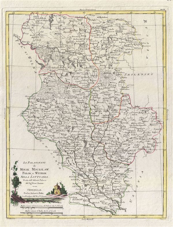
1781 Zatta Map of Minsk, Mscislaw, Polok and Witebsk, Poland
Minsk-zatta-1781$300.00

Title
Li Palatinati di Minsk, Mscislaw, Polok, e Witebsk Nella Littuania.
1781 (dated) 17 x 13 in (43.18 x 33.02 cm)
1781 (dated) 17 x 13 in (43.18 x 33.02 cm)
Description
A fine map of the Palatinates of Minsk, Mscislaw, Polok and Witebsk, Poland. This map covers from parts of Poland from Sokolnikow to Plost and from Wilna to the Russian border. Though culturally intact, by 1781 Poland had gone through two partitions. When this map was issued most of the territory depicted here was under Russian suzerainty. A title cartouche depicting a country scene set in the lower left quadrant. This map was drawn by Antonio Zatta for Rizzi Zanoni's 1781 Atlante Polacco.
CartographerS
Antonio Zatta (1775 - April 2, 1797) was the most prominent Italian map publisher of the late 18th and early 19th century. His firm, based in Venice, produced maps that mark an important transition from 18th to 19th century cartographic styles. He updates and redefines the traditional title cartouche by replacing the mythic elements common to the 17th and 18th century with more representative images. His maps also strive to keep many 18th century details, such as figural depictions on the map itself, while striving for the accuracy that a 19th century clientele demanded. His most important work is the four volume Atlante novissima published from 1775 to 1789. More by this mapmaker...
Giovanni Antonio Bartolomeo Rizzi Zannoni (September 2, 1736 - May 20, 1814) was an 18th century Italian cartographer active in Venice and Naples. Zannoni was born in Padua, Italy on September 2, 1736. Between 1749 and 1751 Zannoni studied Astronomy at the University of Padua under John Polen, a prominent astronomer of the period. After leaving the University, Zannoni was commissioned by the King of Poland, Augustus III, to map that country. Zannoni's subsequent survey is considered the first accurate triangulation of Poland. Afterwards Zannoni's services were in high demand and he traveled around much of Europe, working on various surveys in Denmark, Germany, Prussia, and Sweden. Around 1757 Zannoni was caught up in the hostilities surrounding the Seven Year War and, after one battle, was taken to Paris as a prisoner of war. Paris must have suited Zannoni for he remained for nearly 20 years, even taking service with the Paris Engineer's Office. It was also here in Paris the Zannoni developed the cartographic contacts that would lead to his most prolific cartographic publications, including the Atlas Moderne in conjunction with Lattre. In 1781, Zannoni was called to Naples by the Bourbon monarchy to help in the revision of the Charter of 1769. Afterwards he stayed on and produced a numerous important maps of the Kingdom of Naples. Zannoni is considered a careful and precise cartographer and his work, particularly the maps he made in Naples, have been praised by R.V. Tooley as 'remarkable for a marvelously minute attention to detail, and amply deserves the commendation passed upon it by Sir George Fordham' (Tooley, Maps and Mapmakers, 21). Zannoni would spend the remainder of his days in Naples and passed away on May 20, 1814. Learn More...
Source
Zatta, A., Atlante Polacco, (Venice: Rizzi Zannoni) 1781.
Condition
Very good condition. Original platemark visible. Blank on verso.