
1894 Higley / Colton Map of the Mosquito (Mosquitia), Nicaragua

This item has been sold.
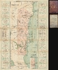
Map of the Mosquito Coast Nicaragua, Central America.
American intervention in the Mosquito.
- Digital Map Information
- Suitable for large format printing
- Full resolution TIFF file
- ICC color profile embedded
- Delivered instantly via download link
American intervention in the Mosquito.
This is an 1894 H. G. Higley commercial map of Nicaragua's Mosquito Coast, compiled by a plantation owner who was also part of the provisional government during Nicaragua's takeover of the Mosquito Reserve - in essence, a commercial map made by an investor participating in a contested transfer of authority, thus mapping foreign capital, environmental change, and political incorporation. Published by G. W. and C. B. Colton, it documents the banana plantations, timber concessions, goldfields, and trading houses transforming the region's economy. The surrounding advertisements connect coastal settlements directly with New Orleans, where most U.S. investment in the Mosquito was based, while its list of government officials places Higley himself within the political transition. The map records the provisional governmental arrangements of March 1894, during the political crisis that subsequently brought American armed intervention to Bluefields that summer.A Closer Look
The map follows Nicaragua's Caribbean coast from Cape Gracias a Dios and the Wanks or Coco River south to Greytown, the San Juan River, and the Costa Rican boundary. Inland coverage reaches the eastern shore of Lake Nicaragua. The Mosquito Reserve is highlighted in pink, with its western boundary explicitly identified, while rivers provide the main framework for settlements and commercial activity. Although the legend includes roads and trails, the map presents no comparable overland network connecting the reserve with western Nicaragua. Its geography faces outward toward Caribbean shipping rather than inward toward the republic's Pacific population centers.The most concentrated development appears along the Bluefields or Escondido River and its tributaries around Rama. Green belts of cultivated land are divided into numbered properties corresponding to two marginal tables containing 60 plantation entries. These identify owners, plantation names, and crops. Bananas predominate, but cacao, vanilla, coconuts, rubber, and livestock also appear. Higley is no disinterested observer: the index names him as owner of Hawkeye, a banana plantation, and Iowena, planted in rubber and cacao. His assistant, Sam D. Spellman, likewise appears in the commercial landscape, both in a plantation partnership and as agent for the Wawa Store.
The agricultural detail records a rapidly changing landscape. Jordana Dym and Karl Offen note that by 1892 plantations extended along 110 miles of the Bluefields or Escondido River, generally in narrow strips accessible from the water. Higley's numbered riverfront properties give this development a particularly tangible form. His coastal annotations also explain its uneven distribution: several river entrances are described as filling with sediment in July and August, imposing seasonal access restrictions. These were practical considerations for merchants shipping perishable fruit, not incidental hydrographic observations.
Farther north, yellow circles identify gold regions, while a dedicated symbol marks Emery's mahogany camps. Warehouses and Emery's Railroad on the Great River make the timber industry's supporting infrastructure visible. Dym and Offen identify the Boston timber entrepreneur George Emery as a concession holder whose interests extended across both the reserve and neighboring Nicaraguan territory. His support for incorporation illustrates how commercial interests could favor removing the very political boundary the map carefully preserves. Moravian mission stations, separately keyed throughout the coastal settlements, record another network operating across this river-dominated territory.
The advertisements are integral to the map's commercial purpose. Arranged like business cards against green ornamental side panels, they offer plantation and mining supplies, general merchandise, shipping agency services, banking, accommodation, and refreshments. The New Orleans and Central American Trading Company gives addresses in both New Orleans and Bluefields. Samuel Weil and Company advertises exports of rubber, gold dust, and coconuts alongside its New Orleans office and cable addresses. Such notices make the exchange explicit: imported goods and services supported the extraction and export of coastal resources.
The inset Plan of Bluefields, Nicaragua, C.A. brings this network down to individual streets and waterfront premises. King, Aberdeen, Clarence, and other streets organize a town in which trading houses and wharves occupy prominent waterside positions. The Bluefields Banana Company, Samuel Weil, Simon Cohn, Wilson and Ingram, and Spellman are located alongside the Moravian Mission, government buildings, an ice factory, and the Nicaraguan commissioner's office. Commercial and governmental authority thus occupy the same closely mapped urban space.
The Takeover of the Mosquito Reserve
The map preserves the reserve's boundary as its autonomy was being dismantled. Under the Treaty of Managua of 1860, Britain recognized Nicaraguan sovereignty while guaranteeing a limited form of local self-government. In 1894, Nicaragua maneuvered to replace that arrangement with direct administration. A contemporary American diplomatic report records that Commissioner Carlos A. Lacayo had been instructed to secure incorporation and extend Nicaragua's laws and language over the territory.Nicaraguan troops occupied Bluefields on February 12, 1894. The ensuing negotiations, foreign naval presence, and provisional governmental arrangements exposed divisions among local residents and foreign investors. Above the Bluefields inset, Higley lists Lacayo as commissioner, Rigoberto Cabezas as inspector for the Atlantic Coast, and a provisional government headed by D. H. Thomas, with Henry G. Higley among its members. Contemporary correspondence independently documents Higley's participation in the provisional council. The compiler was therefore mapping a political transformation in which he was personally involved.
A convention dated November 20, 1894, formally declared incorporation into Nicaragua and adopted the name Department of Zelaya. Higley's contemporaneous mapping of the Mosquito Reserve, along with his provisional-government roster, records that year's transitional arrangements. As matters came to a head, U.S. merchants in Bluefields requested help from the U.S. government. American naval intervention at Bluefields in 1894 exposed the tension between protecting American commercial interests and accepting Nicaraguan sovereignty over the Mosquito Reserve. After Nicaragua occupied Bluefields in February, a July uprising expelled its garrison and temporarily restored the government of Miskito chief Robert Henry Clarence. Marines from USS Marblehead landed to protect American lives and property and prevent further violence, but Washington refused to support American residents seeking to maintain a separate government under Clarence's authority. The intervention therefore protected the foreign commercial community represented on Higley's map without guaranteeing the political autonomy under which its businesses had developed.
Manuscript Evidence of Use
The supplied cover bears ownership inscriptions naming C. H. Hall of Asbury Park, New Jersey. Manuscript alterations also revise the plantation index: E. C. Bolton's printed name at Sylvandell has been crossed out and replaced with Hall Garrison, while another entry for Hall Garrison and Company is marked. These changes suggest a reader updated the map's commercial information after printing, although the annotator's identity and the relationship between the ownership inscription and the plantation partnership remain unestablished.Publication History and Census
The map was compiled at Bluefields by Henry Grant Higley (1851 - 1915), assisted by Sam D. Spellman, and dated 1894. Its lower border carries Higley's copyright notice for the same year. G. W. and C. B. Colton and Company engraved and printed it at 312 Broadway, New York; the supplied example retains its gilt-titled cloth folding covers. The OCLC identifies only one example of the map, in the Library of Congress, in a variant state titled Map of the Mosquito Shore, Nicaragua, Central America.Cartographers
Henry Grant Higley (February 16, 1851 - June 4, 1915) was an American civil engineer and cartographer active in Nicaragua, Ecuador, Chile, and Mexico during the late 19th and early 20th centuries. Born in Cedar Rapids, Iowa, he attended Yale University before returning to his hometown, where he operated a florist's business and extensive gardens. On October 28, 1875, he married Ella M. Nye, who participated in the floral business. By 1894, Higley was working in Bluefields on Nicaragua's Mosquito Coast. His Map of the Mosquito Shore, Nicaragua, Central America, compiled with the assistance of Sam D. Spellman and published in New York by G. W. and C. B. Colton and Company in 1894, combined regional geography and a plan of Bluefields with information about plantations, transportation, settlements, and commercial enterprises. Its advertising margins connected the region's export economy with merchants and suppliers in New Orleans. Higley also participated in the Nicaraguan-backed provisional municipal government organized at Bluefields on March 24, 1894, during President José Santos Zelaya's (1853 - 1919) campaign to incorporate the Mosquito Reserve into Nicaragua. His membership therefore preceded both the United States military intervention beginning in July and the reserve's formal annexation in November 1894. Subsequently, Higley developed a career producing plans and bird's-eye views of Latin American cities, including Guayaquil around 1900, Quito in 1903, Santiago in 1904, and Guadalajara in 1908. These works combined street layouts with pictorial representations of buildings, presenting cities as legible commercial and urban landscapes. His La Ciudad de Guadalajara, prepared with H. F. Cox, was announced in the local press in October 1908 for lithographic production by Rand McNally in Chicago. Higley later resided in Tampico, Mexico, where he died on June 4, 1915. His Guadalajara panorama continued to circulate in revised form after his death, including an edition published in 1926. Further Details...
Joseph Hutchins Colton (July 5, 1800 - July 29, 1893), often publishing as J. H. Colton, was an important American map and atlas publisher active from 1833 to 1897. Colton's firm arose from humble beginnings when he moved to New York in 1831 and befriended the established engraver, Samuel Stiles. He worked under Stiles as the 'Co.' in Stiles and Co. from 1833 to 1836. Colton quickly recognized an emerging market in railroad maps and immigrant guides. Not a cartographer or engraver himself, Colton's initial business practice mostly involved purchasing the copyrights of other cartographers, most notably David H. Burr, and reissuing them with updated engraving and border work. His first maps, produced in 1833, were based on earlier Burr maps and depicted New York State and New York City. Between 1833 and 1855, Colton proceeded to publish a large corpus of guidebooks and railroad maps, which proved popular. In the early 1850s, Colton brought his two sons, George Woolworth Colton (1827 - 1901) and Charles B. Colton (1832 - 1916), into the map business. G. W. Colton, trained as a cartographer and engraver, was particularly inspired by the idea of creating a large and detailed world atlas to compete with established European firms for the U.S. market. In 1855, G.W. Colton issued volume one of the impressive two-volume Colton's Atlas of the World. Volume two followed a year later. Possibly because of the expense of purchasing a two-volume atlas set, the sales of the Atlas of the World did not meet Colton's expectations, and so, in 1856, the firm also issued the atlas as a single volume. The maps contained in this superb work were all original engravings, and most bear an 1855 copyright. All of the maps were surrounded by an attractive spiral motif border that would become a hallmark of Colton's atlas maps well into the 1880s. In 1857, the slightly smaller Colton's General Atlas replaced the Atlas of the World. Most early editions of the General Atlas published from 1857 to 1859 do not have the trademark Colton spiral border, which was removed to allow the maps to fit into a smaller format volume. Their customers must have missed the border because it was reinstated in 1860 and remained in all subsequent publications of the atlas. There were also darker times ahead; in 1858, Colton was commissioned at a sum of 25,000 USD by the government of Bolivia to produce and deliver 10,000 copies of a large format map of that country. Although Colton completed the contract in good faith, delivering the maps at his own expense, he was never paid by Bolivia, which was at the time in the midst of a series of national revolutions. Colton would spend the remainder of his days fighting with the Bolivian and Peruvian governments over this payment, and in the end, after a congressional intervention, he received as much as 100,000 USD in compensation. Nonetheless, at the time, it was a disastrous blow. J. H. Colton and Company is listed as one of New York's failed companies in the postal record of 1859. This led Colton into the arms of Alvin Jewett Johnson and Ross C. Browning. The 1859 edition of Colton's General Atlas lists Johnson and Browning as the 'Successor's to J. H. Colton' suggesting an outright buyout, but given that both companies continued to publish separately, the reality is likely more complex. Whatever the case may have been, this arrangement gave Johnson and Browning access to many of Colton's map plates and gave birth to Johnson's New Illustrated (Steel Plate) Family Atlas. The Johnson's Atlas was published parallel to Colton's atlases well into the 1880s. The Colton firm itself subsequently published several other atlases including an Atlas of America, the Illustrated Cabinet Atlas, the Octavo Atlas of the Union, and Colton's Quarto Atlas of the World. They also published a large corpus of wall maps, pocket maps, and guides. The last known publications of the Colton firm date to 1897 and include a map and a view, both issued in association with the Merchant's Association of New York. Alice M. Colton married August R. Ohman (May 3, 1859 - April 22, 1934) on January 5, 1897. In 1898, Ohman joined the Colton firm, which continued to publish as Colton, Ohman & Co. until 1901. Further Details...
Condition
Good. Toning along fold lines with verso repairs and reinforcement along some folds. Minor reinstatement at a few fold intersections. Pencil annotations here and there.
References
OCLC Map of the Mosquito Coast Nicaragua. Library of Congress, G4852.M6 1894 .H5. Dym, Jordana and Karl Offen, 'Maps and the Teaching of Latin American History,' Hispanic American Historical Review, 92, no. 2 (2012), pp. 226 - 233, figs. 4 - 5. United States Department of State, Foreign Relations of the United States, 1894, Nicaragua (Mosquito Territory), documents 38, 44, and 136. Burton, Tony, 'Henry Grant Higley and his 1908 plan of Guadalajara' (2025), pp. 1 - 3.