
1895 Ōtsuka Usaburō Map of Taiwan, Sino-Japanese War

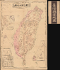
實測詳密 台灣島大地圖 附-澎湖島 琉球島 / [Map of Taiwan Island Measured in Detail, with the Penghu and Ryukyu Islands].
Japanese Seizure of Taiwan.
- Digital Map Information
- Suitable for large format printing
- Full resolution TIFF file
- ICC color profile embedded
- Delivered instantly via download link
Japanese Seizure of Taiwan.
This is an 1895 Ōtsuka Usaburō map of Taiwan, the Penghu Islands (also known as the Pescadores), and the Ryukyu Islands. It was prepared and published during Japan's conquest of Taiwan and includes a range of administratively useful information. The map helped to bring information about Japan's new colonial conquest and soon-to-be 'model colony' to a home audience.A Closer Look
By the time this map was made, Japanese troops controlled most of northern and central Taiwan and were preparing to occupy the island's southern part. The map provides important information on Taiwan's infrastructure, population, and geography. Although the legend does not indicate it, the purple-shaded areas most likely represent regions of relatively heavy settlement. The entire eastern half of the island south of Yilan (宜蘭) is noted as aboriginal territory. These areas were not entirely uncharted; mountain ranges are named, elevations are given for some, and rivers, some coastal settlements, and the names of some groups/tribes are provided. But the level of detail in the Chinese-settled west of the island is much greater, even listing the approximate population (either as population 人口 or households 戶) in different cities and towns. The inset at left depicts a sketch map of the East China Sea (日清韓三國略圖, 1 : 6300000) and the one at bottom-right higlights the Ryukyu Islands (琉球諸島全圖, 1 : 3100000). The box at bottom-left gives the distances by land and sea between various cities or towns and ports, respectively.Taiwan at the Peripheries of Empires
Due to its strategic proximity to the Chinese mainland, Taiwan has been eyed by foreign powers for centuries. The island's early indigenous inhabitants had minimal interaction with Chinese culture until the Ming period, when larger numbers of traders, fishermen, settlers, and pirates operated in the western lowlands or along the coast facing Fujian. Europeans also appeared in the early seventeenth century, and the Dutch and Spanish both built forts. However, the main power in the Taiwan Strait was prominent families of traders and officials from Fujian, especially the Zheng family, who controlled trade routes in the Strait stretching as far as Japan and Southeast Asia.By the time of the Ming's collapse in 1644, the Zheng had evolved their operation into a quasi-state (the Zheng Ministry 鄭部), led by the dynamic but fairly reckless Zheng Chenggong (鄭成功 1624 - 1662, known in European sources as Koxinga). Zheng captured the Dutch Fort Zeelandia, refused to acknowledge the Qing, and even attacked Nanjing, but was driven back to Taiwan, which the Qing eventually captured in 1683. Unsure what to do with the island, the Qing evacuated most of the Chinese population and ruled it at arm's length, but Chinese migration increased throughout the eighteenth and nineteenth centuries, and officials in Beijing viewed it as an annoyance and a lawless frontier. By the time of the First Sino-Japanese War, settlers from the Chinese mainland who lived on the west side of the island far outnumbered the aboriginal population to the east, and, although a border (seen here as 番地境界綫) had been constructed to separate the two communities (mainly to protect aborigines from attack and exploitation by Chinese settlers and to prevent Chinese settlers from fleeing to aboriginal areas to shirk their taxes), the boundaries between these communities were actually quite fluid.
Japan's Growing Clout in East Asia
The background to Japan's occupation of Taiwan can be dated to the Meiji Restoration (1868). Recognizing that colonies were a common element among foreign powers, Meiji leaders set their sights on building both an informal and a formal empire in East Asia. As a distant and often-ignored vassal state of the Qing, the Ryukyu Kingdom was an obvious place to begin imperial expansion. Taiwan was likewise an enticing option. Although a part of the Qing empire, the Japanese rightly determined that the Qing were not especially interested in the island. By the time the Qing court recognized the problems foreign rule of Taiwan would cause, it was already too late.Following the Opium Wars, and especially after the Japanese established a de facto protectorate over the Ryukyu Islands in 1872 and launched a military expedition to Taiwan in 1874, the Qing realized the vulnerabilities that would be created if Taiwan were captured by foreign powers (the French also tried to invade Taiwan in 1884). The Qing established more direct administration of the island, eventually making it a province in 1887, and appointed a modernizer, Liu Mingchuan (劉銘傳), as governor. Liu oversaw the construction of schools, fortifications, and a railway, completed in 1893, which connected Keelung (基隆), Taipei (臺北), and Hsinchu (新竹) and ended at Xiangshan (香山). It was planned to continue to Taiwan-fu (台灣府, that is, Taichung) and to Tainan, but it was not completed before Liu had to leave Taiwan for health reasons. Liu also had telegraph lines installed, including an undersea line connecting Tamsui (淡水港, the port of Taipei) to Fujian Province, seen here.
Japan's Occupation of Taiwan
Japanese forces invaded Taiwan in May 1895, after the Treaty of Shimonoseki (April 17, 1895) ceded it to them at the end of the First Sino-Japanese War (1894 - 1895). The occupation of Taiwan fit into Imperial Japan's Nanshin-ron (南進論) or Southern Expansion Doctrine, which argued that Taiwan, Southeast Asia, and the Philippines were essential to Japan's economic and territorial growth. Katsura Taro (1747 - 1913), a Yamaguchi Samurai, wrote of Taiwan's significance: 'It is not only the most ideal location for expanding power to southern China, but also the islands in Southeast Asia.'Although Japan had been ceded Taiwan by treaty, some indigenous attempts at resistance and self-governance continued, including the founding of the 'Republic of Formosa,' arguably Asia's first republic. Elite troops from Liu Yongfu's 'Black Flag Army,' which had fought the French in Tonkin, also joined the fight. Another challenge was disease, particularly malaria and cholera, which tore through Japanese troop camps and killed far more soldiers than actual combat. By late May, the Japanese had advanced down the west side of the island from north to south, with battles around the walled city of Changhua (彰化) when this map was published. In less than six months, Japanese forces achieved full control of the island, with the arguable exception of the tribal central highlands. However, guerrilla warfare continued in limited form for several years. Taiwan was Japan's first major extraterritorial holding, and Imperial Japan worked diligently to transform it into a showpiece 'model colony.' Japan lavished resources on the island's economy, including public works, industrial development, and cultural Japanization.
Publication History and Census
This map was edited and distributed by Ōtsuka Usaburō (大塚宇三郎), in conjunction with Tanaka Taemon (田中太右衛門), and printed by Sonoda Tōsaburō (園田藤三郎), all based in Osaka. It was printed on September 14, 1895, and released on September 18. The only known institutional holding of this map is with the National Museum of Taiwan History.Cartographers
Ōtsuka Usaburō (大塚宇三郎 ; fl. c. 1882 - 1909), also sometimes using the courtesy name Shisei (子成), was an Osaka-based editor, printer, and publisher of books and maps. He operated in Minami ward of Osaka and worked within a close-knit local publishing network, frequently partnering with research organizations such as the Chiri Kenkyūkai (地理研究会, Geographical Research Society) and printer Sonoda Tōzaburō (園田藤三郎). He also collaborated extensively with the prominent Osaka publishing firm Tanaka Taemon / Tanaka Sōeidō (田中太右衛門 / 田中宋栄堂), which operated just a few doors away on Andōjibashi-dōri in 4-chōme of Minami Ward. Capitalizing on the Meiji public's intense demand for geographic information driven by Japan's overseas military expansion, Ōtsuka produced numerous maps of Taiwan, Korea, and continental East Asia. Alongside his overseas maps, Ōtsuka produced pocket maps catering to travelers navigating Japan's rapidly expanding domestic rail and steamship networks. Beyond cartography, Ōtsuka compiled and published a wide variety of practical Meiji reference books, including Chinese character dictionaries, legal commentaries, and letter-writing manuals. Further Details...
Tanaka Taemon (田中太右衛門; fl. c. 1777 - 1940) was the hereditary name of the family that led Sōeidō (宋栄堂), one of Osaka's most enduring publishing houses, operating from the mid-Edo period until the Second World War. Several branches of the Tanaka family operated in the publishing business in the late Edo period, including the firm founded in 1804 by Tanaka Sōkichi (田中宗吉), a former clerk at the prominent Osaka bookseller Akitaya Ichibei (秋田屋市兵衛). Operating throughout the late Edo period under the merchant trade name Akitaya Taemon (秋田屋太右衛門) alongside the studio name Sōeidō, the house grew into a major regional publisher. It produced and distributed Buddhist texts, classical Chinese (kanbun) commentaries, reference works, and illustrated woodblock books — including collaborations with noted Osaka ukiyo-e artist Matsukawa Hanzan — while frequently co-publishing multi-volume titles with leading bookshops in Edo and Kyoto. Following the Meiji Restoration, as traditional merchant guild names (yagō) gave way to family surnames, the firm transitioned from Akitaya Taemon to Tanaka Taemon / Tanaka Sōeidō, operating Minami Ward in Osaka. Successfully adapting from traditional woodblock printing to modern movable type, the company capitalized on Meiji educational reforms and rising literacy by publishing pocket dictionaries, self-study manuals, school textbooks, and popular classical Chinese anthologies edited by scholars such as Kondō Gensui. It also remained an active publisher and distributor of commercial atlases and regional maps, frequently partnering with neighboring compiler and printer Ōtsuka Usaburō on travel guides and cartographic works. Further Details...
Condition
Very good. Even toning. Original paper slipcase.
References
National Museum of Taiwan History Registration No. 2004.008.0060.0001.