This item has been sold, but you can get on the Waitlist to be notified if another example becomes available, or purchase a digital scan.
1849 Colton Pocket Map or Chart of the World's Mountains and Rivers
MountainsandRivers-colton-1849$750.00

Title
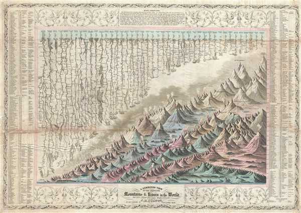
A Combined View of the Principal Mountains and Rivers in the World with Tables showing their relative Heights and Lengths.
1849 (dated) 21 x 29.5 in (53.34 x 74.93 cm)
1849 (dated) 21 x 29.5 in (53.34 x 74.93 cm)
Description
A scarce 1849 pocket format edition of Colton's Mountains and Rivers chart. This is the earliest known iteration of Colton's iconic Mountains and Rivers chart which would later be popularized in his 1855 Atlas of the World and in Johnson's 1860 New Family Atlas. Most likely the finest American Mountains and Rivers chart or map of the mid-19th century. Depicts the relative distances of the world's great rivers and the relative heights of the world's great mountains. Includes a multitude of details regarding the heights of important cities, glaciers, volcanoes, and tree lines. Also includes Niagara Falls, the Great Pyramid, St. Peter's Basilica in Rome and St. Paul's in London. Notes curiosities that would have been relevant at the time, such as 'The Greatest Altitude of the Growth of Peruvian Bark', 'The Glacier of Maladetts', the 'Table Land of Pamar', and the 'Greatest Altitude attained by Humboldt 19400 ft'. Replete with additional geographical errors and misconceptions common to the period. The map is surrounded by decorative embellishments and several layers of border. To the right and left of the map there is a table identifying the individual mountains via a numerical cross reference system. Dated and copyrighted to J. H. Colton, 1849. Published from Colton's 86 Cedar Street address in New York City.
CartographerS
Joseph Hutchins Colton (July 5, 1800 - July 29, 1893), often publishing as J. H. Colton, was an important American map and atlas publisher active from 1833 to 1897. Colton's firm arose from humble beginnings when he moved to New York in 1831 and befriended the established engraver, Samuel Stiles. He worked under Stiles as the 'Co.' in Stiles and Co. from 1833 to 1836. Colton quickly recognized an emerging market in railroad maps and immigrant guides. Not a cartographer or engraver himself, Colton's initial business practice mostly involved purchasing the copyrights of other cartographers, most notably David H. Burr, and reissuing them with updated engraving and border work. His first maps, produced in 1833, were based on earlier Burr maps and depicted New York State and New York City. Between 1833 and 1855, Colton proceeded to publish a large corpus of guidebooks and railroad maps, which proved popular. In the early 1850s, Colton brought his two sons, George Woolworth Colton (1827 - 1901) and Charles B. Colton (1832 - 1916), into the map business. G. W. Colton, trained as a cartographer and engraver, was particularly inspired by the idea of creating a large and detailed world atlas to compete with established European firms for the U.S. market. In 1855, G.W. Colton issued volume one of the impressive two-volume Colton's Atlas of the World. Volume two followed a year later. Possibly because of the expense of purchasing a two-volume atlas set, the sales of the Atlas of the World did not meet Colton's expectations, and so, in 1856, the firm also issued the atlas as a single volume. The maps contained in this superb work were all original engravings, and most bear an 1855 copyright. All of the maps were surrounded by an attractive spiral motif border that would become a hallmark of Colton's atlas maps well into the 1880s. In 1857, the slightly smaller Colton's General Atlas replaced the Atlas of the World. Most early editions of the General Atlas published from 1857 to 1859 do not have the trademark Colton spiral border, which was removed to allow the maps to fit into a smaller format volume. Their customers must have missed the border because it was reinstated in 1860 and remained in all subsequent publications of the atlas. There were also darker times ahead; in 1858, Colton was commissioned at a sum of 25,000 USD by the government of Bolivia to produce and deliver 10,000 copies of a large format map of that country. Although Colton completed the contract in good faith, delivering the maps at his own expense, he was never paid by Bolivia, which was at the time in the midst of a series of national revolutions. Colton would spend the remainder of his days fighting with the Bolivian and Peruvian governments over this payment, and in the end, after a congressional intervention, he received as much as 100,000 USD in compensation. Nonetheless, at the time, it was a disastrous blow. J. H. Colton and Company is listed as one of New York's failed companies in the postal record of 1859. This led Colton into the arms of Alvin Jewett Johnson and Ross C. Browning. The 1859 edition of Colton's General Atlas lists Johnson and Browning as the 'Successor's to J. H. Colton' suggesting an outright buyout, but given that both companies continued to publish separately, the reality is likely more complex. Whatever the case may have been, this arrangement gave Johnson and Browning access to many of Colton's map plates and gave birth to Johnson's New Illustrated (Steel Plate) Family Atlas. The Johnson's Atlas was published parallel to Colton's atlases well into the 1880s. The Colton firm itself subsequently published several other atlases including an Atlas of America, the Illustrated Cabinet Atlas, the Octavo Atlas of the Union, and Colton's Quarto Atlas of the World. They also published a large corpus of wall maps, pocket maps, and guides. The last known publications of the Colton firm date to 1897 and include a map and a view, both issued in association with the Merchant's Association of New York. Alice M. Colton married August R. Ohman (May 3, 1859 - April 22, 1934) on January 5, 1897. In 1898, Ohman joined the Colton firm, which continued to publish as Colton, Ohman & Co. until 1901. More by this mapmaker...
John M. Atwood (1817 - October 12, 1884) was an American engraver based in Philadelphia and New York City during the middle part of the 19th century. Atwood was born in Georgetown, near Washington D.C. Little is known of Atwood's life but most of his work was completed in conjunction with the publishing firms of Horace Thayer and J. H. Colton. A review of Atwood's work suggests that he was a highly accomplished, stylistically distinct, and detail oriented engraver. Colton seems to have turned to Atwood to engrave some of his most important as well as decorative maps. His most influential map is most likely the 1856 De Cordova pocket map of Texas, however, he also engraved the Colton's well known and highly decorative Thirty Three Miles Around New York and Colton's important 1849 Map of the United States. Learn More...
Condition
Good. Blank on verso. Even overall toning. Original fold lines exhibit some wear and damage. Backed with heat adtivated archival tissue.
References
Rumsey 11453.000.