This item has been sold, but you can get on the Waitlist to be notified if another example becomes available, or purchase a digital scan.
1875 U.S. Coast Survey Map of Mount Desert Island, Maine
MountDesertIsland-uscs-1875$175.00

Title
Mount Desert Island Maine.
1875 (dated) 17.5 x 14.25 in (44.45 x 36.195 cm) 1 : 80000
1875 (dated) 17.5 x 14.25 in (44.45 x 36.195 cm) 1 : 80000
Description
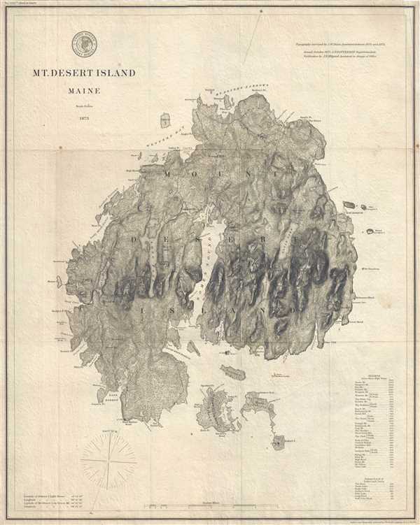
This is an 1875 U.S. Coast Survey map of Mount Desert Island, Maine. An impressively clean and crisp imprint, the map depicts the entire island from Moose Island to Round Porcupine Island and from the Mount Desert Narrows to Baker's Island. Numerous locations throughout the island are labeled, including Bar Harbor, Seal Harbor, Seal Cove, Bass Harbor, Town Hill, and Somesville. Individual buildings are illustrated as black squares throughout the island, though only the lighthouses at Bass Harbor, Baker's Island, and Bear Island are labeled. Roads snake their way around the island, connecting each of the settlements and venturing into the island's interior. A table of heights above mean high water of mountains and other locations on the island is situated in the lower left corner.
Though well before the establishment of Acadia National Park, today Mount Desert Island is celebrated as the home of part of this magnificent national treasure. Acadia was initially established as Sieur de Monts National Monument by President Woodrow Wilson in July 1916. In February 1919, the area's status was officially changed from a National Monument to a National Park, making it the first National Park east of the Mississippi River. With the change to a National Park came a name change as well, with the region now being known as Lafayette National Park. It would not be until January 1929 that the park would be renamed Acadia National Park. Acadia is unlike most other National Parks as its creation was encouraged by numerous private individuals. One of these was John. D. Rockefeller, Jr. Rockefeller purchased a summer home in Bass Harbor in 1910, and began buying land in the park with the goal of creating a system of carriage roads as means of making more accessible to visitors what Rockefeller thought was 'one of the greatest views in the world.'
The topography for this map was surveyed by J.W. Donn, the outlines and topography were engraved by Joseph Enthoffer, and the lettering was engraved by E.A. Maedel. It was issued by the U.S. Coast Survey in October 1875 when Carlile Patterson was Superintendent.
Acadia National Park
Though well before the establishment of Acadia National Park, today Mount Desert Island is celebrated as the home of part of this magnificent national treasure. Acadia was initially established as Sieur de Monts National Monument by President Woodrow Wilson in July 1916. In February 1919, the area's status was officially changed from a National Monument to a National Park, making it the first National Park east of the Mississippi River. With the change to a National Park came a name change as well, with the region now being known as Lafayette National Park. It would not be until January 1929 that the park would be renamed Acadia National Park. Acadia is unlike most other National Parks as its creation was encouraged by numerous private individuals. One of these was John. D. Rockefeller, Jr. Rockefeller purchased a summer home in Bass Harbor in 1910, and began buying land in the park with the goal of creating a system of carriage roads as means of making more accessible to visitors what Rockefeller thought was 'one of the greatest views in the world.'
The topography for this map was surveyed by J.W. Donn, the outlines and topography were engraved by Joseph Enthoffer, and the lettering was engraved by E.A. Maedel. It was issued by the U.S. Coast Survey in October 1875 when Carlile Patterson was Superintendent.
CartographerS
The Office of the Coast Survey (1807 - present) founded in 1807 by President Thomas Jefferson and Secretary of Commerce Albert Gallatin, is the oldest scientific organization in the U.S. Federal Government. Jefferson created the "Survey of the Coast," as it was then called, in response to a need for accurate navigational charts of the new nation's coasts and harbors. The spirit of the Coast Survey was defined by its first two superintendents. The first superintendent of the Coast Survey was Swiss immigrant and West Point mathematics professor Ferdinand Hassler. Under the direction of Hassler, from 1816 to 1843, the ideological and scientific foundations for the Coast Survey were established. These included using the most advanced techniques and most sophisticated equipment as well as an unstinting attention to detail. Hassler devised a labor intensive triangulation system whereby the entire coast was divided into a series of enormous triangles. These were in turn subdivided into smaller triangulation units that were then individually surveyed. Employing this exacting technique on such a massive scale had never before been attempted. Consequently, Hassler and the Coast Survey under him developed a reputation for uncompromising dedication to the principles of accuracy and excellence. Unfortunately, despite being a masterful surveyor, Hassler was abrasive and politically unpopular, twice losing congressional funding for the Coast Survey. Nonetheless, Hassler led the Coast Survey until his death in 1843, at which time Alexander Dallas Bache, a great-grandson of Benjamin Franklin, took the helm. Bache was fully dedicated to the principles established by Hassler, but proved more politically astute and successfully lobbied Congress to liberally fund the endeavor. Under the leadership of A. D. Bache, the Coast Survey completed its most important work. Moreover, during his long tenure with the Coast Survey, from 1843 to 1865, Bache was a steadfast advocate of American science and navigation and in fact founded the American Academy of Sciences. Bache was succeeded by Benjamin Pierce who ran the Survey from 1867 to 1874. Pierce was in turn succeeded by Carlile Pollock Patterson who was Superintendent from 1874 to 1881. In 1878, under Patterson's superintendence, the U.S. Coast Survey was reorganized as the U.S. Coast and Geodetic Survey (C & GS) to accommodate topographic as well as nautical surveys. Today the Coast Survey is part of the National Oceanic and Atmospheric Administration or NOAA as the National Geodetic Survey. More by this mapmaker...
Carlile Pollock Patterson (August 24, 1816 - August 15, 1881) was the fourth superintendent of the United States Coast Survey. Born in Shieldsboro (now Bay St. Louis), Mississippi and the son of the American naval officer Daniel Todd Patterson (1786 - 1839), Carlile joined the navy as a midshipman in 1830. He graduated from Georgetown College in Kentucky as a civil engineer in 1838 and was attached to the U.S. Coast Survey from 1838 - 1841. In 1841, he was commissioned as a lieutenant. As commander of the Coast Survey schooner Phoenix, Patterson led the first USCS hydrographic expedition of the Gulf of Mexico in 1845. Patterson resigned from the Navy in 1853. At the outbreak of the Civil War in 1861, Patterson returned to federal service as a civilian hydrographic inspector in the Coast Survey, in charge of the charting and survey work. He was appointed as the Superintendent of the U.S. Coast and Geodetic Survey in 1874, a post he held until his death. Learn More...
Joseph Enthoffer (1818 - April 6, 1909) was an Austrian-American copper-plate engraver. Enthoffer immigrated to the United States in 1857 to accept a position as an engraver for the United States Coast Survey and worked for the Survey until he retired in 1899. He married his wife Elizabeth in St. Petersburg, Russia in 1855 and they had three children. Learn More...
Condition
Very good. Even overall toning. Backed on archival tissue for stability. Blank on verso.