This item has been sold, but you can get on the Waitlist to be notified if another example becomes available, or purchase a digital scan.
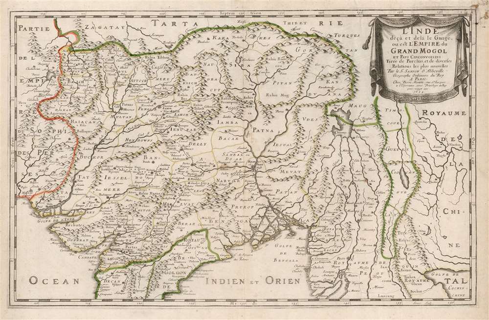
1654 Nicolas Sanson Map of the Mughal Empire and its Neighbors
MughalEmpire-sanson-1654$375.00

Title
L'Inde deçà et de là Gange, ou est L'Empire do Grand Mogol et Pays Circonvoisins Tirée de Purchas, et de diverses Relations les plus nouvelles.
1654 (dated) 13.25 x 21 in (33.655 x 53.34 cm) 1 : 8800000
1654 (dated) 13.25 x 21 in (33.655 x 53.34 cm) 1 : 8800000
Description
This is an attractive example of Nicolas Sanson's 1654 map of the Mughal Empire of Northern India. It is a significant illustration of the early Silk Route trade networks between India and Kabul. The map thus embraces the northern parts of modern India, Pakistan, Afghanistan, Bangladesh, and Burma, as well as parts of Thailand, Laos, and Vietnam.
A Closer Look
Its core is derived from the unacquirable 1619 Baffin / Roe map. (Probably via the 1625 printed version appearing in Purchas his Pilgrimes. Sanson credits Purchas in the cartouche.) As such, the map features an early, accurate mapping of the Indus River, as well as western and central India. At its heart, the map reveals the vital trade routes between the chief cities of Gujarat, Agra, and Jaisalmer, and their linkage to the Silk Road center of Kabul. While the map does not depict roads, it does illustrate the network of towns, waystations, and caravanserai built to support the bustling trade system. In particular, it reveals the administrative route linking the Imperial palaces at Agra and Lahore.The Source
The lion's share of this map - and virtually every seventeenth century map of northern India - is based on William Baffin's Indostan, the first English map of India, made based on the travels and geographical information of Sir Thomas Roe, the British East India Company's ambassador to the Mughal Empire. Roe and Baffin are thought to have worked on their map during Roe's 1619 return to England aboard the ship Anne Royal, following Roe's tenure as ambassador. Baffin, formerly an arctic explorer, was employed as a surveyor by the East India Company and served as a Master's Mate on Anne Royal. Roe was tasked to produce a map of the Empire in India, compiling geographical data on thirty-seven cities. Baffin added these to the map with difficulty, as he needed to reconcile Roe's data with his own charts and others that remained authoritative. Their 1619 manuscript survives in a single copy in the British Library and the map was published that year, itself surviving in only a single example, also at the British Library. Despite its present prohibitive rarity, the map's influence was monumental.West of the Indus
Sanson's map includes details north of Kandahar and west of Kabul that do not appear on the Baffin, or its more common derivatives such as the Jansson. Neither does Sanson's treatment of this area resemble Jansson's treatment on his map of the Persian Empire. Sanson's source for this region is obscure.The Lake of Chiamay
Prominent at the eastern limit of the map is the Lake of Chiamay, the apocryphal source of four important Southeast Asian river systems including the Irrawaddy, the Dharla, the Chao Phraya, and the Brahmaputra. This lake (also called Chiam-may or Chian-may) began to appear in maps of this region as early as the 16th century and persisted well into the mid-18th century. Its origins are unknown but may originate in a lost 16th century geography prepared by the Portuguese scholar Jao de Barros. It was speculated to be the source of five important Southeast Asian River systems and was mentioned in the journals of Sven Hedin. There are even records that the King of Siam led an army to seize of the lake in the 16th century.East of Chiamay
Just as Sanson's map reaches further west than its English or Dutch sources, it extends further east as well. The Kingdom of Pegu (now Burma) and the northern part of Vietnam (Tunquin) appear, as does part of the Gulf of Tonkin (Golfe de Cochinchine, here.) But north of this, the regions of Timocoues, Gueyes, Ciocangue, and Layes (Laos) appear at the headwaters of the Mekong River. Blaeu's map of Southeast Asia obscures this region with a cartouche. The detail of Martino Martini's China does not reach so far west, and we are not aware of an earlier map to name these areas. Certainly, Richard Blome in his 1667 General Mapp of the East Indies would batten on to Sanson's detail here, as he did with the rest of his maps. But just as with the western regions in this map, Sanson's source map for Laos and points north is obscure to us.Publication History and Census
This map was engraved by Jan Somer for inclusion in Sanson's atlases, published in partnership with Pierre Mariette. Thirteen examples are listed in institutional collections. The map appears on the market from time to time.CartographerS
Nicolas Sanson (December 20, 1600 - July 7, 1667) and his descendants were the most influential French cartographers of the 17th century and laid the groundwork for the Golden Age of French Cartography. Sanson was born in Picardy, but his family was of Scottish Descent. He studied with the Jesuit Fathers at Amiens. Sanson started his career as a historian where, it is said, he turned to cartography as a way to illustrate his historical studies. In the course of his research some of his fine maps came to the attention of King Louis XIII who, admiring the quality of his work, appointed Sanson Geographe Ordinaire du Roi. Sanson's duties in this coveted position included advising the king on matters of geography and compiling the royal cartographic archive. In 1644, he partnered with Pierre Mariette, an established print dealer and engraver, whose business savvy and ready capital enabled Sanson to publish an enormous quantity of maps. Sanson's corpus of some three hundred maps initiated the golden age of French mapmaking and he is considered the 'Father of French Cartography.' His work is distinguished as being the first of the 'Positivist Cartographers,' a primarily French school of cartography that valued scientific observation over historical cartographic conventions. The practice result of the is less embellishment of geographical imagery, as was common in the Dutch Golden Age maps of the 16th century, in favor of conventionalized cartographic representational modes. Sanson is most admired for his construction of the magnificent atlas Cartes Generales de Toutes les Parties du Monde. Sanson's maps of North America, Amerique Septentrionale (1650), Le Nouveau Mexique et La Floride (1656), and La Canada ou Nouvelle France (1656) are exceptionally notable for their important contributions to the cartographic perceptions of the New World. Both maps utilize the discoveries of important French missionaries and are among the first published maps to show the Great Lakes in recognizable form. Sanson was also an active proponent of the insular California theory, wherein it was speculated that California was an island rather than a peninsula. After his death, Sanson's maps were frequently republished, without updates, by his sons, Guillaume (1633 - 1703) and Adrien Sanson (1639 - 1718). Even so, Sanson's true cartographic legacy as a 'positivist geographer' was carried on by others, including Alexis-Hubert Jaillot, Guillaume De L'Isle, Gilles Robert de Vaugondy, and Pierre Duval. More by this mapmaker...
Pierre Mariette (1569 - 1657) was a French publisher and engraver active in Paris during the first half of the 19th century. Mariette established himself as successful publisher of art prints, but decided to turn his energy to cartography with the purchase of the plates for Melchior Tavernier's maps in 1644. Tavernier had partnered with Sanson before his death and Mariette followed suit. Around 1644- 1648 Mariette partnered with Nicolas Sanson, a then nascent figure in French cartography, to produce folio maps and atlases. The Sanson-Mariette relationship depended upon Sanson to draw and obtain rights for the maps while Mariette engraved them and paid for the expensive printing process. The two then shared rights to the maps into perpetuity. The finished copper plates were split between two such that neither could publish an atlas without the other's assent. The relationship seemed reasonably amicable until Mariette's death in 1657, when disputes arose between Sanson and Mariette's heirs. A court battle finally returned the most of the plates to Sanson's own heirs in 1674. As a consequence, some printings feature the Mariette imprint, others the Sanson imprint, and still others both imprints. Learn More...
William Baffin (c. 1584 – January 23, 1622) was an English navigator, explorer and cartographer. His efforts to discover a Northwest Passage would earn his fame, largely resulting from his discovery of the bay that bears his name. He is also known for having produced excellent surveys of the Red Sea and the Persian Gulf on behalf of the East India Company, and his collaboration on the most influential map of Northern India to be produced in the seventeenth century. Nothing is known of his early life. Samuel Purchas hailed Baffin as a 'learned-unlearned Mariner and Mathematician... wanting art of words,' conjuring a working sailor whose grasp of survey and drafting came of long experience and not education. He first appears in the historical record in 1612 as chief pilot on Captain James Hall's fourth expedition to Greenland; in the following two years he would serve as in the Muscovy Company whaling fleet around Spitzbergen. In 1615 he was hired by the Company of Merchants of London, Discoverers of the North-West Passage' and sailed as pilot under Captain Robert Bylot, who explored Hudson Strait in search of a Northwest Passage. Baffin's surveys were found to be accurate, confirmed by the explorer Parry in 1821. Returning to the Hudson Strait in 1616 he passed west of Greenland up the Davis Strait, discovering the large bay now known as Baffin's Bay and reaching the furthest point in North America explored by a European until the voyage of Inglefield in 1852. Following his efforts to find a Northwest Passage, he served the East India Company as master's mate aboard the ship Anne Royal. His travels to India between 1617 and 1619 would result in his vaunted surveys of the Red Sea and the Persian Gulf, and his superb map of the Mughal Empire produced in collaboration with Ambassador Sir Thomas Roe. In 1620, he sailed east again, taking part in a naval battle with a combined Portuguese and Dutch fleet which would see his captain killed. Baffin was shot and killed in 1622, as part of a joint effort with Persia to take Portuguese fortresses on Qeshm and Hormuz. Learn More...
Jean Pruthenus Somer (fl. 1650 - 1663), aka Sommer, also known as Jean Somers Pruthenus ('Pruthenus' means 'The Prussian'), was a Prussian engraver active in Paris in the middle part of the 17th century. Somer worked extensively for Sanson and Mariette, for whom he was the principal map engraver. His imprint appears on many of Sanson's most influential maps. Learn More...
Source
Sanson, N. and G. Cartes et Tables de la Geographie Ancienne et Nouvelle, (Paris: Mariette) 1657.
Condition
Very good. Few stains to upper right; else excellent with original outline color.
References
OCLC 921702828. Rumsey 9741.121. Gole, S., Early Maps of India, #16, plate 12.