
Somer, Jean

Jean Pruthenus Somer (fl. 1650 - 1665), aka Sommer, also known as Jean Somers Pruthenus ('Pruthenus' means 'The Prussian'), was a Prussian engraver active in Paris in the middle part of the 17th century. Somer worked extensively for Sanson and Mariette, for whom he was the principal map engraver. His imprint appears on many of Sanson's most influential maps.
First specific map of Vietnam.
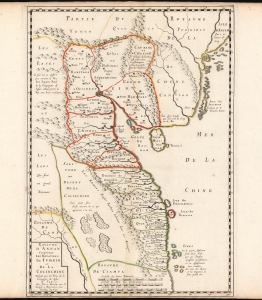
Carte du Royaume d'Annam, comprenant les Royaumes du Tumkin et de la Cocinchine.
$9,500.00
Acquire
- Digital Map Information
- Suitable for large format printing
- DPI: 600
- File Size: 12.7 MB
- File Type: ZIP / TIFF
- ICC color profile embedded
- Delivered instantly via download link
This is the Alexander de Rhodes and Pierre Mariette 1653 map of Vietnam, considered the first specific map of the Kingdom of Annam, or Tonkin, today's North Vietnam. This map represents a major milestone in the mapping of Vietnam and would prove the underpinning cartography of this region through the mid-19th century. (more details)
Kyiv after Beauplan's Firsthand Survey. During the Russo-Polish War (1654 - 1667).
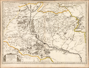
Basse Volhynie, ou Palatinate de Kiow.
$2,000.00
Acquire
- Digital Map Information
- Suitable for large format printing
- Full resolution TIFF file
- ICC color profile embedded
- Delivered instantly via download link
This is a beautifully engraved 1665 map of central Ukraine by Nicolas Sanson. Published during the Russo-Polish War (1654 - 1667), it is the earliest French iteration of the geography of Franco-Polish cartographer, engineer, and architect Guillaume Levasseur de Beauplan. Beauplan produced the best 17th-century survey of the Dniepr and laid the foundation for the modern mapping of Ukraine. (more details)