Digital Image: 1654 Nicolas Sanson Map of the Mughal Empire and its Neighbors
MughalEmpire-sanson-1654_d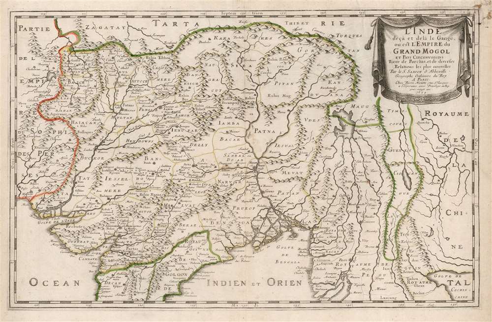

Title
L'Inde deçà et de là Gange, ou est L'Empire do Grand Mogol et Pays Circonvoisins Tirée de Purchas, et de diverses Relations les plus nouvelles.
1654 (dated) 13.25 x 21 in (33.655 x 53.34 cm) 1 : 8800000
1654 (dated) 13.25 x 21 in (33.655 x 53.34 cm) 1 : 8800000
Description
FOR THE ORIGINAL ANTIQUE MAP, WITH HISTORICAL ANALYSIS, CLICK HERE.
Digital Map Information
Geographicus maintains an archive of high-resolution rare map scans. We scan our maps at 300 DPI or higher, with newer images being 600 DPI, (either TIFF or JPEG, depending on when the scan was done) which is most cases in suitable for enlargement and printing.
Delivery
Once you purchase our digital scan service, you will receive a download link via email - usually within seconds. Digital orders are delivered as ZIP files, an industry standard file compression protocol that any computer should be able to unpack. Some of our files are very large, and can take some time to download. Most files are saved into your computer's 'Downloads' folder. All delivery is electronic. No physical product is shipped.
Credit and Scope of Use
You can use your digial image any way you want! Our digital images are unrestricted by copyright and can be used, modified, and published freely. The textual description that accompanies the original antique map is not included in the sale of digital images and remains protected by copyright. That said, we put significant care and effort into scanning and editing these maps, and we’d appreciate a credit when possible. Should you wish to credit us, please use the following credit line:
Courtesy of Geographicus Rare Antique Maps (https://www.geographicus.com).
How Large Can I Print?
In general, at 300 DPI, you should at least be able to double the size of the actual image, more so with our 600 DPI images. So, if the original was 10 x 12 inches, you can print at 20 x 24 inches, without quality loss. If your display requirements can accommodate some loss in image quality, you can make it even larger. That being said, no quality of scan will allow you to blow up at 10 x 12 inch map to wall size without significant quality loss. For more information, it is best consult a printer or reprographics specialist.
Refunds
If the high resolution image you ordered is unavailable, we will fully refund your purchase. Otherwise, digital images scans are a service, not a tangible product, and cannot be returned or refunded once the download link is used.
Cartographer S
Nicolas Sanson (December 20, 1600 - July 7, 1667) and his descendants were the most influential French cartographers of the 17th century and laid the groundwork for the Golden Age of French Cartography. Sanson was born in Picardy, but his family was of Scottish Descent. He studied with the Jesuit Fathers at Amiens. Sanson started his career as a historian where, it is said, he turned to cartography as a way to illustrate his historical studies. In the course of his research some of his fine maps came to the attention of King Louis XIII who, admiring the quality of his work, appointed Sanson Geographe Ordinaire du Roi. Sanson's duties in this coveted position included advising the king on matters of geography and compiling the royal cartographic archive. In 1644, he partnered with Pierre Mariette, an established print dealer and engraver, whose business savvy and ready capital enabled Sanson to publish an enormous quantity of maps. Sanson's corpus of some three hundred maps initiated the golden age of French mapmaking and he is considered the 'Father of French Cartography.' His work is distinguished as being the first of the 'Positivist Cartographers,' a primarily French school of cartography that valued scientific observation over historical cartographic conventions. The practice result of the is less embellishment of geographical imagery, as was common in the Dutch Golden Age maps of the 16th century, in favor of conventionalized cartographic representational modes. Sanson is most admired for his construction of the magnificent atlas Cartes Generales de Toutes les Parties du Monde. Sanson's maps of North America, Amerique Septentrionale (1650), Le Nouveau Mexique et La Floride (1656), and La Canada ou Nouvelle France (1656) are exceptionally notable for their important contributions to the cartographic perceptions of the New World. Both maps utilize the discoveries of important French missionaries and are among the first published maps to show the Great Lakes in recognizable form. Sanson was also an active proponent of the insular California theory, wherein it was speculated that California was an island rather than a peninsula. After his death, Sanson's maps were frequently republished, without updates, by his sons, Guillaume (1633 - 1703) and Adrien Sanson (1639 - 1718). Even so, Sanson's true cartographic legacy as a 'positivist geographer' was carried on by others, including Alexis-Hubert Jaillot, Guillaume De L'Isle, Gilles Robert de Vaugondy, and Pierre Duval. More by this mapmaker...
Pierre Mariette (1569 - 1657) was a French publisher and engraver active in Paris during the first half of the 19th century. Mariette established himself as successful publisher of art prints, but decided to turn his energy to cartography with the purchase of the plates for Melchior Tavernier's maps in 1644. Tavernier had partnered with Sanson before his death and Mariette followed suit. Around 1644- 1648 Mariette partnered with Nicolas Sanson, a then nascent figure in French cartography, to produce folio maps and atlases. The Sanson-Mariette relationship depended upon Sanson to draw and obtain rights for the maps while Mariette engraved them and paid for the expensive printing process. The two then shared rights to the maps into perpetuity. The finished copper plates were split between two such that neither could publish an atlas without the other's assent. The relationship seemed reasonably amicable until Mariette's death in 1657, when disputes arose between Sanson and Mariette's heirs. A court battle finally returned the most of the plates to Sanson's own heirs in 1674. As a consequence, some printings feature the Mariette imprint, others the Sanson imprint, and still others both imprints. Learn More...
William Baffin (c. 1584 – January 23, 1622) was an English navigator, explorer and cartographer. His efforts to discover a Northwest Passage would earn his fame, largely resulting from his discovery of the bay that bears his name. He is also known for having produced excellent surveys of the Red Sea and the Persian Gulf on behalf of the East India Company, and his collaboration on the most influential map of Northern India to be produced in the seventeenth century. Nothing is known of his early life. Samuel Purchas hailed Baffin as a 'learned-unlearned Mariner and Mathematician... wanting art of words,' conjuring a working sailor whose grasp of survey and drafting came of long experience and not education. He first appears in the historical record in 1612 as chief pilot on Captain James Hall's fourth expedition to Greenland; in the following two years he would serve as in the Muscovy Company whaling fleet around Spitzbergen. In 1615 he was hired by the Company of Merchants of London, Discoverers of the North-West Passage' and sailed as pilot under Captain Robert Bylot, who explored Hudson Strait in search of a Northwest Passage. Baffin's surveys were found to be accurate, confirmed by the explorer Parry in 1821. Returning to the Hudson Strait in 1616 he passed west of Greenland up the Davis Strait, discovering the large bay now known as Baffin's Bay and reaching the furthest point in North America explored by a European until the voyage of Inglefield in 1852. Following his efforts to find a Northwest Passage, he served the East India Company as master's mate aboard the ship Anne Royal. His travels to India between 1617 and 1619 would result in his vaunted surveys of the Red Sea and the Persian Gulf, and his superb map of the Mughal Empire produced in collaboration with Ambassador Sir Thomas Roe. In 1620, he sailed east again, taking part in a naval battle with a combined Portuguese and Dutch fleet which would see his captain killed. Baffin was shot and killed in 1622, as part of a joint effort with Persia to take Portuguese fortresses on Qeshm and Hormuz. Learn More...
Jean Pruthenus Somer (fl. 1650 - 1663), aka Sommer, also known as Jean Somers Pruthenus ('Pruthenus' means 'The Prussian'), was a Prussian engraver active in Paris in the middle part of the 17th century. Somer worked extensively for Sanson and Mariette, for whom he was the principal map engraver. His imprint appears on many of Sanson's most influential maps. Learn More...
Source
Sanson, N. and G. Cartes et Tables de la Geographie Ancienne et Nouvelle, (Paris: Mariette) 1657.
References
OCLC 921702828. Rumsey 9741.121. Gole, S., Early Maps of India, #16, plate 12.