
1778 Ohata Ukiyo-e View of Nagasaki, Japan

This item has been sold.
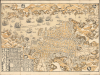
[肥州長嵜圖 / Map of Nagasaki, Hishū].
Tokugawa Japan's Constrained Cosmopolitanism.
Choose a Collection:
- Digital Map Information
- Suitable for large format printing
- File Size: 45.72 MB
- File Type: ZIP / TIFF
- ICC color profile embedded
- Delivered instantly via download link
This Item
Enquire
Tokugawa Japan's Constrained Cosmopolitanism.
This is a 1778 Ōhata Bunjiemon ukiyo-e woodblock print city plan or map of Nagasaki, Japan, at the height of the Tokugawa or Edo period. Although that period was defined by strict isolationist policies, Nagasaki served as the one port allowed to conduct regular trade with foreigners, who feature prominently here.A Closer Look
Oriented towards the northwest, this map covers both shores of Nagasaki Bay, recording streets, bridges, temples, shrines, agricultural fields, mountains, and other features. Both Japanese and foreign ships appear in the harbor, with the foreign ships named, though often with a generic name like 'Holland ship' (ヲランダ入舟), as with the ship at left being towed by two lines of smaller Japanese boats. Others are labeled 'foreign ship' (畨舟). Tables at the bottom-left provide information on distances between Nagasaki and various cities and domains (國) throughout Japan. Some curious locations are labeled along the edges of the city, including a hilltop tea garden (御茶園) towards the bottom-left and an area for outcasts (非人) on the right, likely referring to burakumin (部落民), who held hereditary 'impure' professions, such as gravediggers and butchers.Dejima (出島), an artificial island near the center, was Japan's only open port to the Western world for most of the Tokugawa period (1600 - 1868). The Dutch were granted exclusive trading rights, and Dejima retains a Dutch flag atop a tall flagpole here. To the immediate south of Dejima is the 'New Area' (Shinchi 新地), which developed into Nagasaki's Chinatown, and to its south is Tōjinyashiki (唐人屋敷), another quarter reserved for Chinese merchants. Chinese merchants were generally freer to move about the city than the Dutch, which may explain an additional Tōjin (Chinese) area to the west of the other two, which also houses 'foreigners' (畨人). It is unclear who these generic foreigners were. Most likely, they were Siamese, who also had been permitted to trade at Nagasaki for much of the Tokugawa period (though in reality, these 'Siamese' ships were generally run by Chinese traders moving between Ayutthaya and Nagasaki), or Koreans or Ryukyuans, whose tribute missions to Edo often passed through Nagasaki. 'Moorish' (i.e., Persian) traders also visited Nagasaki during the period of sakoku (discussed below).
A Small Opening to the World
For most of the Edo or Tokugawa Era (1600 - 1868), Japan operated under Sakoku (鎖国, 'Locked Country') policies, where foreign trade and interaction were allowed with the Dutch and Chinese at Nagasaki and through other tightly constrained channels, but otherwise were forbidden to prevent potentially troublesome foreign ideas like Christianity from undermining Tokugawa rule. Nevertheless, some Japanese intellectuals, particularly of the 'Dutch Learning' (Rangaku) School, were aware of developments in the outside world, and the Tokugawa became quietly but increasingly concerned about foreign threats. Whalers, adventurers, and would-be traders from Russia, Europe, and the United States appeared on Japan's shores with increasing frequency in the late 18th and early 19th centuries (including a group of American ships sailing under a Dutch flag during the Napoleonic Wars). Eventually, Japan was forced open to the rest of the world by the visits of American Commodore Matthew Perry in the early 1850s, setting off a process that led to the downfall of the Tokugawa and the rapid modernization of the country.Nagasaki-e (長崎繪)
Nagasaki-e is a sub-genre of ukiyo-e woodblock prints that took the interactions between Japanese and foreigners (Chinese and Dutch) at Nagasaki as its subject, along with related subjects, such as exotic foreign goods brought by foreign traders. The genre became established starting in the 1720s, gaining popularity in the 1750s, and reflects a distinct Chinese influence, both in the material used (initially 'Chinese-style' drafting paper called gasenshi in Japanese) and in style (resembling Chinese nenga or nianhua 年画, traditionally produced for Lunar New Year celebrations). Although usually indicating the printer, the artists of these works are generally unknown, likely because they were amateurs and sometimes foreigners. Still, Nagasaki-e proved popular among the Japanese, often being sold as souvenirs for visitors to the port city. They provided an important peek into the outside world for the Japanese, at least of a certain social class, during the Tokugawa period and presaged the later Yokohama-e that became wildly popular in the 1860s.Publication History and Census
This map was printed in the eighth month of the 7th year of the An'ei era (安永七戊戌年八月), or 1778, by Ōhata Bunjiemon (大畠文次右衛門), a resident of Nagasaki. It is untitled, but is generally given the title of 'Hishū Nagasaki zu' (肥州長崎圖). This is an early edition of Ōhata's map, which was first published in 1764 (with a slightly different title printed on the map, '肥州長崎之圖'). The map was reissued with updates for decades afterwards, nearly until the end of the Tokugawa period, especially by the firm Baikodo (梅香堂). Most obviously and often, the ships in the harbor were modified between different editions (see, for comparison, our smaller format Nagasaki-baikodo-1860). Outside of Japan, examples of the present edition of the map are held by Yale University, the University of Hawaii, the University of California Berkeley, the University of British Columbia, Brigham Young University, and Leiden University.Condition
Excellent.
References
OCLC 1105190561, 21844272. Shimada, R. and Nagazumi, Y., 'Siamese Products in the Japanese Market during the Seventeenth and Eighteenth Centuries' in Large and Broad: The Dutch Impact on Early Modern Asia. Essays in Honor of Leonard Blussé, (Tokyo: Toyo Bunko) 2010, pp. 147 - 165.