
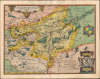
1595 Ortelius Map of Namur, Belgium and Environs

This item has been sold.
Namurcum Comitatus.
Battleground of the Eighty Years' War.
- Digital Map Information
- Suitable for large format printing
- Full resolution TIFF file
- ICC color profile embedded
- Delivered instantly via download link
Battleground of the Eighty Years' War.
This is an attractive, old color example of Abraham Ortelius' map of Namur and environs in Wallonia, Belgium, which appeared in the 1595 edition of his Theatrum Orbis Terrarum. This area was heavily impacted by the Wars of Religion and the Eighty Years WarA Closer Look
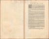
The map is roughly centered on Namur, at the confluence of the Meuse and Sambre Rivers. Cities, villages, waterways, and forests are labeled and illustrated throughout, while regions are color-shaded for distinction. Decorative cartouches appear around the title at top-left, a curious compass rose at right, and at bottom-right, displaying the coat of arms of Namur (including the Flemish lion but with a distinct red diagonal line) and putti. Oretlius' source for this map, named at bottom-right, was Jacques Surhon (d. 1557), who had produced a manuscript map of the region in 1555. The text on the verso discusses the toponym of Namur, its resources, cities, and fortifications.Historical Context
Like much of Europe at the time, Wallonia was divided by the fallout from the Protestant Reformation, including the Wars of Religion, as well as by the struggle for local autonomy against the Habsburg Kings of Spain who ruled the Netherlands. While the Reformation gained ground in other cities in Wallonia, King Philip II (r. 1556 - 1598) planned to maintain Namur as a bastion of resolute Catholicism; quite literally so, as the Citadel of Namur, sitting at the confluence of the Sambre and Meuse, had recently been upgraded. This effort succeeded and the Walloon Reformed Church was forced into exile. However, the atrocious behavior of mercenaries employed by the Spanish in suppressing Protestantism and separatism in the Netherlands alienated many, even in staunchly Catholic areas like Namur, leading it to join the Pacification of Ghent in 1576. However, in response Philip II sent Alexander Farnese, Duke of Parma, his nephew and one of his most capable lieutenants, to pacify the southern Netherlands, mostly by placating Walloon nobles. Jesuits were also sent to reinforce Catholicism against Protestant provocateurs. In the following years, Spanish control over Namur and Wallonia writ large was solidified and the area became a Habsburg stronghold.Publication History and Census
The present map appeared in the 1595 Latin edition of Ortelius' Theatrum Orbis Terrarum, of which 500 Copies were printed. It was first included in the 1579 edition of the Theatrum and continued to appear until 1609. In its various printings, this piece is well-represented in institutional collections and occasionally appears on the market.Cartographer
Abraham Ortelius (April 14, 1527 - June 28, 1598) also known as Ortels, was a cartographer, geographer, and cosmographer of Brabant, active in Antwerp. He was the creator of the first modern atlas, Theatrum Orbis Terrarum and is a seminal figure in the history of cartography. Along with Gerard Mercator and Gemma Frisius, he was a founder of the Netherlandish school of cartography. His connections with Spain - culminating in his 1575 appointment as Royal Cartographer to King Phillip II of Spain - gave him unmatched access to Spanish geographical knowledge during a crucial period of the Age of Discovery. Ortelius was born in 1527 in Antwerp. In 1547 he entered the Antwerp Guild of Saint Luke as an illuminator of maps. He began trading in books, prints, and maps, traveling regularly to the Frankfurt book and print fair, where in 1554 he met Mercator. He accompanied Mercator on journeys throughout France in 1560 and it was at this time, under Mercator's influence, that he appears to have chosen his career as a scientific geographer. His first published geographic work appeared in 1564, an eight-sheet cordiform world map. A handful of other maps preceded the 1570 publication of the first edition of the Theatrum Orbis Terrarum, which would prove to be his life work. Appearing with but 53 maps in its first edition, Ortelius' work expanded with new maps added regularly. By 1592, it had 134 maps. Many of Ortelius' maps remained the standard for nearly a century. He traveled extensively, but his genius was as a compiler, locating the best informed maps on which to base his own. His contacts throughout Europe and extending even (via the Portuguese) to the Far East were formidable. Moreover, many of his maps were based on his own scholarship, particularly his historical works. His theories of geography were particularly ahead of his time with respect to the notion of continental drift, the possibility of which he mused on as early as 1596, and which would be proven correct centuries later. In a sense his greatest achievement was his successful navigation of the religious and political violence endemic to his city throughout his adult life: The Dutch Revolt, or Eighty Years' War (1568 - 1648), fully embroiled Antwerp. Although outwardly and officially recognized as Catholic (Arias Montanus vouched for Ortelius' Catholic orthodoxy prior to his appointment as Royal Geographer), Ortelius was able to separate himself from the religious furor which characterized the war in the low countries. Ortelius showed a glimpse of himself in a letter to a friend, regarding humanist Justus Lipsius: 'I do not know whether he is an adherent of the Pope or a Calvinist, but if he has ears to hear, he will neither be one nor the other, for sins are committed on both sides'. Ortelius' own explorations of Biblical history in his maps, and the Christogram contained in his own motto, suggest him to be a religious man, but his abjuration of political religious authorities mark him as an individualist. His tombstone at St Michael's Præmonstratensian Abbey in Antwerp bears the inscription, Quietis cultor sine lite, uxore, prole. ('served quietly, without accusation, wife, and offspring.') Further Details...
Source
Ortelius, A., Theatrum Orbis Terrarum, (Antwerp: Plantin) 1595.
Abraham Ortelius' magnum opus, Theatrum Orbis Terrarum, was the world's first regularly produced atlas, which 'set the standards for later atlases ... It was the first undertaking of its kind to reduce the best available maps to an uniform format.' (Koeman) A modestly-sized work of fifty-three maps in its first edition of May 1570, it was an immediate success: there were three further editions that year, and the work remained in print for a total of 32 editions, the last of which was 1641, well after its author's 1598 death. Ortelius added to his atlas constantly, and by 1595 the Theatrum contained 147 maps. Ortelius is renowned generally as an editor, and indeed much of the Theatrum is compiled from a variety of sources: in such cases, Ortelius was scrupulous in naming his sources. But Ortelius was also a mapmaker in his own right: many of his maps are a distillation of various sources into his own work, and there were many maps - particularly in his atlas of Biblical and ancient history Parergon - which were entirely Ortelius' work. In his role as an editor, Ortelius followed in the footsteps of Munster, whose Cosmographia was, until Ortelius, the best window on the world for the curious European reader. In terms of the artistry of his maps, Ortelius oversaw the first great flourishing of copperplate engraving in the service of cartography to occur in Northern Europe. Ortelius' work provided the model for the atlases of Mercator, Hondius, Blaeu and all their progeny in the 17th century - many of whom were to produce faithful editions of Ortelius' maps in their own productions.
Condition
Very good. Light dampstaining in margins, toning at bottom of centerfold.
References
Rumsey 10001.153 (1579 Ed.). OCLC 551923548.