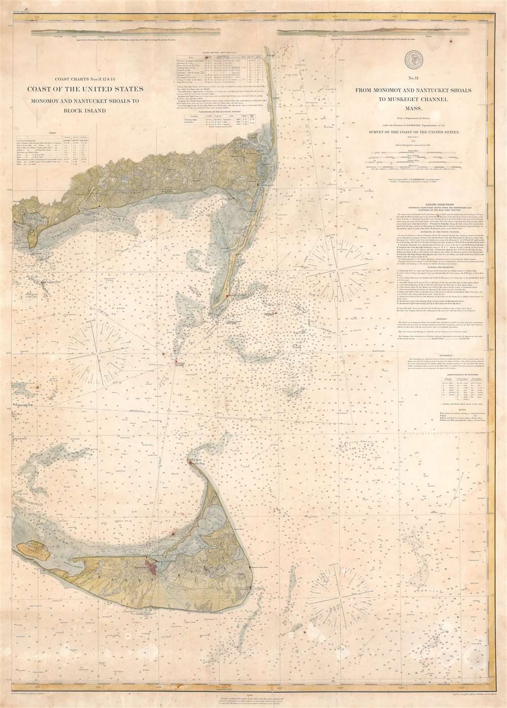
1883 U.S. Coast Survey Nautical Chart or Map of Nantucket, Massachusetts
Nantucket-uscs-1883-2$700.00

Title
No. 11 From Monomoy and Nantucket Shoals to Muskeget Channel Mass.
1883 (dated) 38.75 x 27.5 in (98.425 x 69.85 cm) 1 : 80000
1883 (dated) 38.75 x 27.5 in (98.425 x 69.85 cm) 1 : 80000
Description
This is an uncommon 1883 U.S. Coast and Geodetic Survey nautical chart or maritime map of Nantucket, Massachusetts. The map depicts from Hyannis to Chatham Port and south to include most of Nantucket Island to Old Man's Shoal, with the exception of the western-most part of the island, which extends beyond the map's scope. Primarily concerned with coastal information, the map nonetheless offers detail throughout with topography extending several miles inland. Nantucket is illustrated with full topography. Countless depth soundings appear throughout, and the region's lighthouses, bells, and light boats are highlighted. In addition, a wealth of practical information for the mariner is included: sailing instructions, tidal notes, and information concerning lighthouses and beacons.
Publication History and Census
This chart was first issued under A. D. Bache in 1866, with the present example being updated under C. P. Patterson to 1883. Unlike many Coast Survey charts, the present map is a separate issue and a working maritime chart. Examples of previous and subsequent editions of this chart are cataloged in OCLC, but none dating from 1883 appear in the database.CartographerS
The Office of the Coast Survey (1807 - present) founded in 1807 by President Thomas Jefferson and Secretary of Commerce Albert Gallatin, is the oldest scientific organization in the U.S. Federal Government. Jefferson created the "Survey of the Coast," as it was then called, in response to a need for accurate navigational charts of the new nation's coasts and harbors. The spirit of the Coast Survey was defined by its first two superintendents. The first superintendent of the Coast Survey was Swiss immigrant and West Point mathematics professor Ferdinand Hassler. Under the direction of Hassler, from 1816 to 1843, the ideological and scientific foundations for the Coast Survey were established. These included using the most advanced techniques and most sophisticated equipment as well as an unstinting attention to detail. Hassler devised a labor intensive triangulation system whereby the entire coast was divided into a series of enormous triangles. These were in turn subdivided into smaller triangulation units that were then individually surveyed. Employing this exacting technique on such a massive scale had never before been attempted. Consequently, Hassler and the Coast Survey under him developed a reputation for uncompromising dedication to the principles of accuracy and excellence. Unfortunately, despite being a masterful surveyor, Hassler was abrasive and politically unpopular, twice losing congressional funding for the Coast Survey. Nonetheless, Hassler led the Coast Survey until his death in 1843, at which time Alexander Dallas Bache, a great-grandson of Benjamin Franklin, took the helm. Bache was fully dedicated to the principles established by Hassler, but proved more politically astute and successfully lobbied Congress to liberally fund the endeavor. Under the leadership of A. D. Bache, the Coast Survey completed its most important work. Moreover, during his long tenure with the Coast Survey, from 1843 to 1865, Bache was a steadfast advocate of American science and navigation and in fact founded the American Academy of Sciences. Bache was succeeded by Benjamin Pierce who ran the Survey from 1867 to 1874. Pierce was in turn succeeded by Carlile Pollock Patterson who was Superintendent from 1874 to 1881. In 1878, under Patterson's superintendence, the U.S. Coast Survey was reorganized as the U.S. Coast and Geodetic Survey (C & GS) to accommodate topographic as well as nautical surveys. Today the Coast Survey is part of the National Oceanic and Atmospheric Administration or NOAA as the National Geodetic Survey. More by this mapmaker...
Carlile Pollock Patterson (August 24, 1816 - August 15, 1881) was the fourth superintendent of the United States Coast Survey. Born in Shieldsboro (now Bay St. Louis), Mississippi and the son of the American naval officer Daniel Todd Patterson (1786 - 1839), Carlile joined the navy as a midshipman in 1830. He graduated from Georgetown College in Kentucky as a civil engineer in 1838 and was attached to the U.S. Coast Survey from 1838 - 1841. In 1841, he was commissioned as a lieutenant. As commander of the Coast Survey schooner Phoenix, Patterson led the first USCS hydrographic expedition of the Gulf of Mexico in 1845. Patterson resigned from the Navy in 1853. At the outbreak of the Civil War in 1861, Patterson returned to federal service as a civilian hydrographic inspector in the Coast Survey, in charge of the charting and survey work. He was appointed as the Superintendent of the U.S. Coast and Geodetic Survey in 1874, a post he held until his death. Learn More...
Julius Erasmus Hilgard (January 7, 1825 - May 9, 1890) was a German-American engineer and Director of the United States Coast Survey. Born in Zweibrüken, Rhenish Bavaria, he and his family emigrated to the United States in 1835. They arrived in New Orleans on Christmas Day and traveled from there to a farm in Belleville, Illinois. Hilgard went to Philadelphia in 1843 to study engineering. It was in Philadelphia that Hilgard met Professor Alexander Bache, the recently appointed Superintendent of the United States Coast Survey. In 1845, Bache gave Hilgard a position with the Coast Survey, although his official appointment was delayed for some reason until December 28, 1846. Hilgard worked with the Coast Survey off and on for the rest of his life. At the outbreak of the Civil War, Hilgard was engaged in a prominent business enterprise in Paterson, New Jersey, but Bache convinced him to return to the Coast Survey to supplement in the war effort. In 1862, Hilgard 'assumed charge of the Coast Survey office', taking on the duties of Superintendent in lieu of Bache, who had, by this time, become extremely ill. Upon Bache's death in 1867, Hilgard became the de-facto Superintendent as well as the assistant in charge of the office. He served as such until February 1867 when Benjamin Pierce was appointed Superintendent. Hilgard continued to work for the Coast Survey under Pierce as 'assistant in charge of office' until he was formally appointed Superintendent in 1881, a position he held until 1885 when he was forced to resign due to illness. He died 5 years later. Learn More...
Alexander Dallas Bache (July 19, 1806 - February 17, 1867) was an American physicist, scientist and surveyor. Bache is best known in cartographic circles as the Superintendent of the U.S. Coast Survey from 1843 to 1865. Born in Philadelphia, Bache, a great grandson of the statesman and inventor Benjamin Franklin, had a varied career primarily focused on education. He toured Europe on behalf of Girard College and composed an important treatise on European Education. Later he served as president of Philadelphia's Central High School and was a professor of natural history and chemistry at the University of Pennsylvania. On the death of Ferdinand Rudolph Hassler, Bache was appointed Superintendent of the United States Coast Survey. Picking up where Hassler left off Bache presided over the Survey during its most prolific period and oversaw the mapping of most of the United States coastline. To this day his name appears on countless marine pilot books and U.S. Coast Survey nautical charts. For his work he was elected Associate Fellow of the American Academy of Arts and Sciences, a Fellow of the Royal Society of Edinburgh, and a Foreign Member of the Royal Society. Following the Civil War, Bache was elected a 3rd Class Companion of the Military Order of the Loyal Legion of the United States. He died at Newport, Rhode Island and was buried in the Congressional Cemetery in Washington, DC, where he is commemorated with a monument built by American architect Henry Hobson Richardson. Learn More...
Condition
Good. Some soiling. Used nautical chart. Repaired closed tear extending about 4 inches from lower margin. Closed margin tears professionally repaired on verso. Blank on verso.