1704 Mortier/ Blaeu Panorama of Naples
Naples-mortier-1704$2,500.00

Title
Napoli.
1704 (undated) 16.5 x 39.25 in (41.91 x 99.695 cm)
1704 (undated) 16.5 x 39.25 in (41.91 x 99.695 cm)
Description
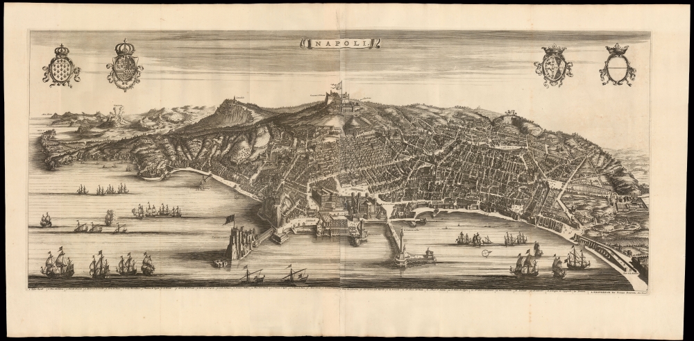
This is Pierre Mortier's 1704 edition of Joan Blaeu's magnificent, two-sheet panorama of Naples, one of the grandest portrayals of the great seaport created in the 17th century.
A Closer Look
The city is viewed from the east over the Gulf of Naples, with the panorama centered on the Castel Sant'Elmo overlooking the city and its landmark waterfront: the Castel dell'Ovo, the Castel Nuovo, and the Molo command the foreground. The harbor is teeming with ships. In the background, the Hermitage of Camaldol and the Flavian Amphitheater can be recognized. In the distance, a volcano - the Solfatara di Pozzuoli - smokes menacingly. At the foot of the engraving, a legend identifies 29 locations on the view by number. The panorama is derived from an earlier one, engraved by Alessandro Baratta, and published in 1629 by Giovanni Orlandi. (We know of two surviving examples of this work, one in the Bibliothèque National de France and the other displayed in the Hall of the Cupids in Naples.) We see no examples of Blaeu's edition of the map at auction or in dealer catalogs. This Mortier edition appears from time to time.Publication History and Census
The view was engraved by Bastaien Stopendaal for inclusion in Joan Blaeu's city atlas in 1663; it first saw print in Blaeu's 1663 Theatrum Civitatum et admirandorum Italiae. Following the fiery end of the Blaeus' publishing house in 1672, the plates passed to Pierre Mortier. In his hands, the plate was amended to remove the imprint, and to add the view's legend and named landmarks. The present edition was published in 1704 as part of Mortier's Nouveau Theatre d'Italie.CartographerS
Joan (Johannes) Blaeu (September 23, 1596 - December 21, 1673) was a Dutch cartographer active in the 17th century. Joan was the son of Willem Janszoon Blaeu, founder of the Blaeu firm. Like his father Willem, Johannes was born in Alkmaar, North Holland. He studied Law, attaining a doctorate, before moving to Amsterdam to join the family mapmaking business. In 1633, Willem arranged for Johannes to take over Hessel Gerritsz's position as the official chartmaker of the Dutch East India Company, although little is known of his work for that organization, which was by contract and oath secretive. What is known is his work supplying the fabulously wealthy VOC with charts was exceedingly profitable. Where other cartographers often fell into financial ruin, the Blaeu firm thrived. It was most likely those profits that allowed the firm to publish the Theatrum Orbis Terrarum, sive, Atlas Novus, their most significant and best-known publication. When Willem Blaeu died in 1638, Johannes, along with his brother Cornelius Blaeu (1616 - 1648) took over the management of the Blaeu firm. In 1662, Joan and Cornelius produced a vastly expanded and updated work, the Atlas Maior, whose handful of editions ranged from 9 to an astonishing 12 volumes. Under the brothers' capable management, the firm continued to prosper until the 1672 Great Amsterdam Fire destroyed their offices and most of their printing plates. Johannes Blaeu, witnessing the destruction of his life's work, died in despondence the following year. He is buried in the Dutch Reformist cemetery of Westerkerk. Johannes Blaeu was survived by his son, also Johannes but commonly called Joan II, who inherited the family's VOC contract, for whom he compiled maps until 1712. More by this mapmaker...
Pierre Mortier (January 26, 1661 - February 18, 1711) or Pieter Mortier was a cartographer, engraver, and print seller active in Amsterdam during the later 17th and early 18th centuries. Mortier, then known as Pieter, was born in Leiden. He relocated to Paris from 1681 to 1685, adopting the French name Pierre, which he retained throughout his career. While in France, he developed deep French connections by bringing sophisticated Dutch printing technology and experience to nascent French map publishers such as Guillaume De L'Isle (1675 - 1726), Alexis-Hubert Jaillot (c. 1632 - 1712), and Nicholas de Fer (1646 - 1720). Consequently, much of Mortier's business was built upon issuing embellished high quality editions of contemporary French maps - generally with the permissions of their original authors. In the greater context of global cartography, this was a significant advantage as most Dutch map publishes had, at this point, fallen into the miasma of reprinting their own outdated works. By contrast, the cartographers of France were producing the most accurate and up to date charts anywhere. Mortier's cartographic work culminated in the magnificent nautical atlas, Le Neptune Francois. He was awarded the Privilege, an early form of copyright, in 1690. Upon Pierre's death in 1711 this business was inherited by his widow. In 1721, his son Cornelius Mortier took over the day to day operation of the firm. Cornelius partnered with his brother-in-law Jean Covens to form one of history's great cartographic partnerships - Covens and Mortier - which continued to publish maps and atlases until about 1866. Learn More...
Source
Mortier, P., Nouveau Theatre d'Italie, (Amsterdam) 1704.
Condition
Excellent. Printed to two sheets, joined as published. Mend at one fold not impacting printed image, else fine with a bold strike.
References
OCLC 494560047.