
1944 Navy Education Services Double-Sided Pictorial Map of Europe and the North Pacific

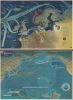

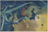
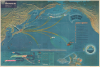
NavWarMap No. 3 World War 2 in the North Sea Area. / NavWarMap No. 4 The North Pacific Area.
Informing and inspiring the Navy in WWII.
$1,250.00
Choose a Collection:
- Digital Map Information
- Suitable for large format printing
- Full resolution TIFF file
- ICC color profile embedded
- Delivered instantly via download link
This Item
Enquire
Informing and inspiring the Navy in WWII.
This is a 1944 double-sided Navy Education Services pictorial map, with northwestern Europe and the North Atlantic on one side and the northern Pacific Ocean on the other. These maps were issued for distribution to American naval personnel with the intent to both inform and inspire.A Closer Look
The European map depicts the region from the Atlantic Ocean to Russia and from the Arctic Ocean to central France and Switzerland; the Pacific map illustrates the Pacific basin from the Chinese coast to the Pacific coast of the United States and from the Bering Sea to Hawaii and Taiwan.NavWarMap No. 3 World War II in the North Sea Area
This map offers a clear portrait of the conflict at that moment by depicting two crucial dimensions of the war in Europe: the Battle of the Atlantic and the Allied strategic bombing campaign against targets in France and Germany.The Battle of the Atlantic
Winston Churchill, the British Prime Minister during World War II, claimed that the only part of the war that ever truly frightened him was the 'U-boat peril'. As the war in continental Europe raged, Britain was fighting for its very survival in the Atlantic. Churchill believed that Germany's best hope of winning the war was through the destruction of Allied shipping. Between the fall of France in June 1940 and the end of that year, German U-boats, mines, and aircraft succeeded in sinking three million tons of Allied shipping. If Britain had been cut off from the rest of the world by Hitler's 'wolfpacks', the war surely would have been lost. Through Allied persistence and commitment, along with new technology, tactics, and intelligence efforts, the effectiveness of German U-boats gradually waned. The Battle of the Atlantic was never truly 'won' by either side, and it was one of the longest campaigns in the war. Between 75,000 and 85,000 Allied seamen perished while ferrying supplies across the Atlantic.Strategic Bombing in Europe
The tactic of strategic bombing was practiced by both Allied and Axis forces, and not only in Europe. Japanese forces mercilessly bombed targets in China and elsewhere during the Pacific War, while the Americans firebombed many Japanese cities. Both sides believed that using air power to destroy enemy targets would damage the enemy's ability to prosecute the war. Raids on both military and industrial targets were organized by both sides, along with missions that specifically targeted civilian populations in an effort to terrorize and disrupt.A Closer Look at the Map Itself
Elements of both the Battle of the Atlantic and the Allied strategic bombing campaigns are illustrated here. Large, light blue arrows spread across the Atlantic, illustrating Allied convoys, particularly as they broke 'the U-boat scourge on the Allies' supply lines'. Five numbered captions trace one of the most talked-about events of the Battle of the Atlantic, the sinking of the Bismarck. The Bismarck, and her sister ship the Tirpitz, were the largest battleships in the German navy and, consequently, the largest battleships built in Europe. If she had been able to reach the Atlantic safely, the destruction wrought upon Allied convoys would have been disastrous. However, through friendly forces in the Swedish Navy, British military officials were alerted that the Bismarck was heading for the Atlantic, a fact supported by radio intercepts from Bletchley Park. After a series of engagements across the North Atlantic, the Bismarck succumbed to British torpedoes.As for the Allied strategic bombing campaign, R.A.F. and U.S.A.A.F. forces are illustrated bombing targets in the French cities of Brest, Lorient, Rouen, Le Havre, and Paris, along with German targets in the industry-rich region of the Ruhr Valley, Hamburg, and Berlin itself, labeled with a Nazi eagle holding a blood-red swastika.
NavWarMap No. 4 The North Pacific Area
NavWarMap No. 4 presents in startling color and clarity the events of World War II in the North Pacific through the beginning of 1944. Japan's coordinated offensives across the Pacific spread like an octopus's arms and scored victories at Pearl Harbor and Wake Island. Pearl is illustrated in flames, and Wake, which valiantly held out against an overwhelming assault as long as they could, is marked by a radio tower stating, 'Send More Japs!' The Japanese were not universally successful, however, since their forces were turned back at Dutch Harbor, evicted from Attu, and abandoned their gains on Kiska. Doolittle's famous raid on Japan in B-25s launched from the U.S.S. Hornet is illustrated, as are American raids on Wake Island and Marcus Island and their continual submarine attacks on Japanese shipping. A chronology detailing Japanese aggression, from their annexation of Formosa (Taiwan) following an 'unprovoked' war with China in 1895 through the Russo-Japanese War (1904 - 1905) and the outbreak of the Second Sino-Japanese War (1937 - 1945) to the multi-pronged assault on December 7/8, 1941, is included on the right.The Battle of Midway
The Battle of Midway is remembered as one of the turning points in the Pacific. The battle, which took place on June 4 - 7, 1942, is summarized graphically in an inset in the lower-left corner. The Japanese planned the battle as a trap for the American aircraft carriers, hoping to destroy them all and leave Japan free to dominate the Pacific. Unfortunately for the Japanese, American cryptologists had broken their code (which was not public knowledge when this map was published), and the U.S. Navy laid a trap of its own. In one of the world's most decisive naval battles, U.S. Navy aircraft launched from three aircraft carriers successfully sank four Japanese aircraft carriers and destroyed over 300 enemy planes. These losses, combined with those suffered by the Japanese during the Guadalcanal Campaign, were irreplaceable. Unlike the U.S., the Japanese did not have the capacity to train the highly skilled pilots and mechanics lost during these campaigns, or to build enough new carriers. Midway, in the opinion of military historian John Keegan, is 'the most stunning and decisive blow in the history of naval warfare'.The Battle of Attu
One of the many aspects of World War II that has been lost in popular memory is that the Japanese did occupy American soil during the war. While the U.S. Navy was winning a decisive victory at Midway, a Japanese landing force landed on and occupied the islands of Attu and Kiska in the Aleutian Islands on June 6-7, 1942. The operation was hoped to distract the Americans from defending Midway (which obviously did not happen), but the Japanese construction of fortifications and air bases on the two islands immediately worried American officials. It would not be until May 1943 that American forces were capable of landing on Attu, the furthest of the two islands, which is the operation detailed in the inset on the lower right. 15,000 Americans landed at Attu and fought an occupying force of 2,900 determined Japanese soldiers from May 11 until May 30, when Attu was declared secure. As is noted here, the occupation force on Kiska abandoned the island before American troops landed there.The NavWarMap Series
These NavWarMaps are part of a series of six maps that were created by the Bureau of Naval Personnel, which was part of the Navy Department. These include:- NavWarMap No. 1 The Mediterranean
- NavWarMap No. 2 The South China Sea Area
- NavWarMap No. 3 World War II in the North Sea Area
- NavWarMap No. 4 The North Pacific Area
- NavWarMap No. 5 Southwest Pacific
- NavWarMap No. 6 We Fight a Global War
Publication History and Census
This map was created within the Bureau of Naval Personnel, most likely by the training division, and distributed by the Educational Services Section. It is important to remember that this map, and the others in the NavWarMap series, were created both to inform and to motivate Allied soldiers, sailors, and airmen. Usually, when we encounter examples of maps from this series, they have been folded. Here, surprisingly, this example has never been folded, giving it a pristine appearance that most others in this series lack. No OCLC references exist for the individual maps. One OCLC entry catalogs nine institutions that possess the entire set of six in their collection, which are: Franklin and Marshall College, the Ohio State University, the University of Michigan, the University of Wisconsin, the Wisconsin Historical Society, the University of Florida, Idaho State University, the National Library of Australia, and Monash University in Clayton, Australia.Condition
Very good. Double sided. Light wear along original fold lines. Slight loss at a few fold intersections. Verso repairs to fold separations.
References
OCLC 53073135.