This item has been sold, but you can get on the Waitlist to be notified if another example becomes available, or purchase a digital scan.
1866 Dutton and Smith Map of New England, New York, and Canada
NewEngland-dutton-1866$600.00

Title
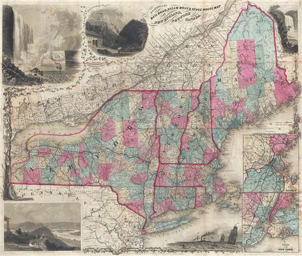
E.P. Dutton and Co.'s Railroad, Steam Boat, and Stage Route Map of New England, New York, and Canada.
1866 (dated) 22.75 x 26.5 in (57.785 x 67.31 cm) 1 : 1600000
1866 (dated) 22.75 x 26.5 in (57.785 x 67.31 cm) 1 : 1600000
Description
This is an exceptionally decorative 1866 map of New England and New York issued by Edward Payson Dutton. Centered on Vermont, the map coves from Like Erie to Cape Cod and from Northern Maine to Long Island and New York City. The map was prepared to illustrate New England's expansive railroad, steam boat, and stage coach system – at the time the most comprehensive transportation network in the United States. The map is surrounded by impressive decorative vignettes doubtless intended to promote travel and tourism in the region. These include Niagara Falls, Crawford Notch (White Mountains), Mount Holyoke (Massachusetts), Montmorency Falls (Quebec), and a nonspecific nautical scene. Two submaps in the lower right corner detail Boston and New York City. Although the focus of Dutton's map is New England and New York, it also offers exceptional detail in Upper and Lower Canada (Quebec and Ontario, respectively).
The map was engraved for Dutton by J. Calvin Smith and first issued in 1863. Editions followed in 1866 (present example) and 1868. It is surprisingly scarce, with only 6 examples identified in institutional collections and single public sale recorded in 2006.
The map was engraved for Dutton by J. Calvin Smith and first issued in 1863. Editions followed in 1866 (present example) and 1868. It is surprisingly scarce, with only 6 examples identified in institutional collections and single public sale recorded in 2006.
CartographerS
John Calvin Smith (1809 – June 11, 1890) was an American surveyor and geographer active in New York during the middle part of the 19th century. He was a charter member of the American Geographical and Statistical Society (American Geographical Society). He worked with other important New York cartographers including John Disturnell, George Sherman, and Samuel Stiles, with whom he often published under the Stiles, Sherman & Smith imprint. Stiles may have introduced Smith to J. H. Colton, who acquired many of his map plates in 1853. Most of Smith's maps focus on New York counties, but he also issued maps of the United States, Illinois, Texas, and the California gold fields. Despite being an important and prolific cartographer, much of his personal life and history are shrouded in mystery. More by this mapmaker...
Edward Payson 'E.P.' Dutton (January 4, 1831 - September 6, 1923) was an American book publisher. Born in Keene, New Hampshire, Dutton was the son of George Damon Dutton and Mary Dutton. In 1852, Dutton founded the E.P. Dutton bookselling company in Boston, Massachusetts. Dutton initially sold fiction and nonfiction books, but soon included children's literature in his inventory. In 1864, Dutton opened a store in New York City and permanently moved his operation there in 1869. In that same year Dutton began publishing books. In 1888, Dutton began working with Ernest Nistor, and in 1906 Dutton struck a lucrative deal with the English publishing firm J.M. Dent to be the American distributor of the Everyman's Library. Even after his death, Dutton's company continued to grow prosper and is now an imprint of the Penguin Group. Dutton married Julia Maria Sleeper. Learn More...
Condition
Very good. Backed on archival tissue for stability. Blank on verso. Wear and toning on original fold lines.
References
OCLC 965806581. Boston Public Library, Leventhal Center, G3721.P3 1863 .S65.