
1876 Illustrated London News Large View of New York City

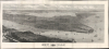
New York from Bergen Hill : Hoboken.
Iconic panorama of Manhattan.
- Digital Map Information
- Suitable for large format printing
- Full resolution TIFF file
- ICC color profile embedded
- Delivered instantly via download link
Iconic panorama of Manhattan.
This is a large-format (20.75 x 45.5 in.) bird's-eye view map of New York City published in 1876 as a supplement to the Illustrated London News. It captures the city the same year Central Park was completed, following decades of population growth and on the cusp of even greater transformation at the turn of the 20th century, which would bring skyscrapers, bridges, and the subway.A Closer Look
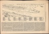
The view is oriented towards the east, looking over Manhattan and Long Island from Bergen Hill, a high point in Hoboken, New Jersey, just across the Hudson River. Manhattan is illustrated from the Battery to roughly 96th Street. The Reservoir, today known as the Jacqueline Kennedy Onassis Reservoir, is visible at the extreme left. Hoboken appears in the foreground, and in the distance, Downtown Brooklyn, Williamsburg, and Long Island City are recognizable. Some of the larger buildings, generally church spires, are exaggerated in the vertical. Among these, both Trinity Church and St. Paul's Chapel in the Financial District stand out. Union Square Park, Madison Square Park, and Bryant Park (next to the massive, granite-walled Croton Distributing Reservoir) are also easily identifiable. The Hudson River, East River, and New York Harbor are busy with maritime traffic, including ferries, commercial ships, and sailing yachts. The view predates the construction of any major bridges across the Hudson or East Rivers, although the foundations of the Brooklyn Bridge can be seen on either side of the East River.The view is accompanied by a key explaining noticeable features in the view. Text at the bottom describes the city, sometimes in rather snarky terms, with the Illustrated London News seeming to prefer Philadelphia and Boston to New York among American cities.
Publication History and Census
This view was drawn by Thomas Sulman, engraved in a woodcut by Robert Loudan, and then transferred to lithographic stone for publication as a supplement to the Illustrated London News, and issued on August 19, 1876. This year was significant for both the U.S. Centennial and the completion of Central Park. This view is cataloged in the OCLC among the holdings of the Library of Congress, the New York Public Library, Boston Public Library, Pennsylvania State University, and the University of Reading.Cartographers
Illustrated London News (1842 - 1971) was one of the world's first weekly news magazines It was first published by Herbert Ingram and Mark Lemon (of Punch fame) in 1842. The lavishly illustrated magazine slowly gained popularity and continued to be published on a weekly basis until 1971. Today the Illustrated London News is the Illustrated London News Group and publishes bi-annually. Further Details...
Thomas Sulman (c.1834 – 1900) was an English architectural draftsman. Sulman studied at The Working Men’s College between 1854 and 1858, where he was a student of, and later an engraver for, Dante Gabriel Rossetti. He is best known for using balloons to capture birds-eye views of various cities including London, Oxford, Glasgow and New York. Most of his view were issued in association with the Illustrated London News and engraved by Robert Loudan Sr. In 1891 he produced high-level views of major London thoroughfares for Herbert Fry's London: Illustrated by Twenty Bird's Eye Views of the Principal Streets. These were engraved by George William Ruffle (1838–1901). In addition, Sulman prepared graphics for newspaper and magazine advertisements. Further Details...
Robert Loudan (fl. 1855 – 1895) was a prominent London woodcut engraver active in the middle part of the 19th century. Most of Loudan's work is associated with the Illustrated London News. His most prominent engravings were woodcuts based upon Thomas Sulman's dramatic balloon bird's-eye views of English and American cities. Considering the prominence of his work, it is surprising just how little biographical information exists. We know almost nothing of Loudan's life, education, or character. Further Details...
Condition
Very good. Mounted on linen. Wear along original fold lines. Slight loss along original fold lines. Accompanied by key, which has some closed edge tears that have been professionally repaired on verso. Key sheet dimensions are 9.5x14.75 inches.
References
Library of Congress, Panoramic Maps (2nd ed.), 597.2. OCLC 51137537, 1121597718.