This item has been sold, but you can get on the Waitlist to be notified if another example becomes available, or purchase a digital scan.
1770 / 1874 Beers / Colton / Bernard Ratzer Map of New York City
NewYorkRatzen-beers-1874$4,250.00

Title
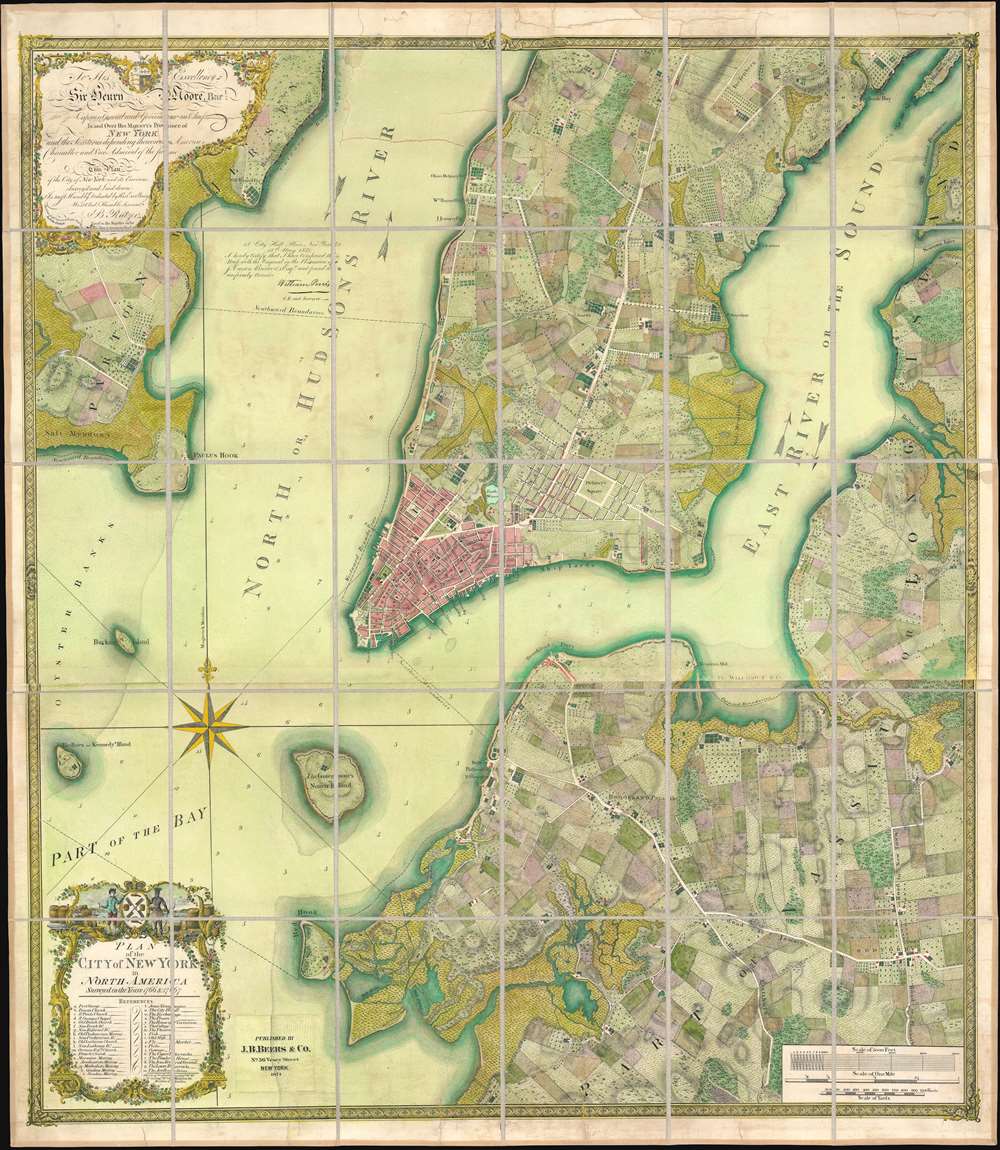
To his excellency Sr. Henry Moore, bart., captain general and governour in chief, in and over his majesty's province of New York and the territories depending thereon in America, chancellor and vice admiral of the same : This plan of the city of New York and its environs, survey'd and laid down ; is most humbly dedicated by his excellency's most obedt. humble servant B. Ratzer.
1853 (dated) 43 x 37.5 in (109.22 x 95.25 cm) 1 : 9800
1853 (dated) 43 x 37.5 in (109.22 x 95.25 cm) 1 : 9800
Description
Known as the 'Ratzer Plan,' this is one of the most important, beautiful, and iconic colonial era maps of New York City, offered here in a stunning 1874 Colton / Beers restrike. This map was originally surveyed in 1767 by Bernard Ratzer, a lieutenant in the 'Royal American' regiment at the behest of Sir George Moore, governor of New York, who is sited in the cartouche. The map, which covers the southern part of Manhattan to about modern day 57th street, is a revision and expansion upon the flawed John Montresor plan of 1767. Across East River, a portion of Long Island is depicted, including most of Brooklyn and Parts of Long Island City.
These 19th century reissues of the Ratzer are extremely rare - indeed, rarer than the 1776 Faden / Jeffreys issue.
Rebellion Fermenting
This map emerged during a period of increasing unrest and political instability throughout England's North American colonies. The British victory in the French and Indian War (1754 - 1763) came at a high cost, leaving the British economy reeling, its national debt nearly doubled, and postwar expenses, including the cost of maintaining 1500 active British Regulars in the colonies, worsened the situation. To alleviate the issue, King George III and Parliament instituted the Stamp Act of 1765, a wildly unpopular direct tax on the colonies intended to defray military costs. The tax incited widespread acts of rebellion, especially in New York, where the Sons of Liberty and other separatist groups fostered a pyric anti-colonial environment.Much Needed Reconnaissance
With effigies of British nobleman and military officers burning in the streets, General Thomas Gage, then commander of British forces in North America, feared open rebellion. In preparation, he ordered Lieutenant John Montresor to immediately compile a plan of Manhattan. Montresor hastily completed the plan in just two months, which he submitted to Gage on February 8, of 1766. The plan suffered from the incommodious circumstances under which it was compiled with few streets named, their distances and orientations imprecise, and little overall detail with few structures noted. Shortly after the map was completed, Montresor returned to England on a leave of absence, taking his map with him for printing.The Quartering Act
In the same year Parliament passed the 1765 Quartering Act, which required New Yorkers to provide housing to British Regulars. While the exceedingly unpopular act was never fully enforced, some 1500 British soldiers, among them the surveyor Bernard (Bernhard) Ratzer, descended upon New York. Ratzer, who had already established a reputation as a fine draughtsman and surveyor during the war, was called upon by Royal Governor of New York, Sir Henry Moore, to refine and complete Montresor's survey. Ratzer worked on the survey throughout the remainder of 1766 and 1767, sending it to England for engraving and publication in the same year. Ratzer continued to refine his survey, producing another larger map of New York City in 1770 and surveying the New York – New Jersey boundary.Putting it all Together
In England, Ratzer's plan was engraved by Thomas Kitchin, one of the foremost engravers then active in London. Kitchin masterfully executed Ratzer's manuscript draught in print form, producing one of the finest maps of any American city then seen. He did however make one significant error, misspelling Ratzer's name as 'Ratzen,' thus forever dubbing this the 'Ratzen Plan.' The 'Ratzen Plan' formed the core of Ratzer's larger map of New York, the 1770 'Ratzer Map,' so named for Kitchin's correction of this error on the earlier work. That map, in turn, is the core of an enormous unpublished manuscript, surviving in the British Library, illustrating all of New York Harbor and the surrounding lands – giving evidence to the full extent of Ratzer's remarkable survey.In Literature
Augustyn and Cohen in Manhattan in Maps comment thatThe Ratzer Map evokes a halcyon period in the history of Manhattan, at least in regard to its physical reality. The city at the time was a small but vibrant place with a population of about twenty-five thousand, for whom the countryside was a short carriage ride away. Also readily at hand were the recreational delights as well as economic advantages of the sea.And indeed, the map reveals a combination of an urban landscape and rich countryside, divided into cultivated fields, gentlemanly estates (including those of Delancey and Rutgers) with geometric gardens, and salt marches. Some evidence also suggests the de-watering of the city – as seen by the partial filling of the Collect Pond, identified here as 'Freth Water' and a smaller drainage reservoir, with streets overlapping, in the Lower East Side. The religious diversity and tolerance for which New York has always been known is also much in evidence. There is a Jewish Cemetery noted in the Lower East Side, near St. James Street, and a variety of churches and synagogues noted in the reference section of the map.
Publication History and Census
This map was engraved by Thomas Kitchin and surveyed by Bernard Ratzer. The dedication references Sir Henry Moore, then governor of the New York. The first state was published in 1770 and was primarily for governmental use and as such saw a limited circulation. Only four surviving copies of the original 1770 issue remain, but the plan was reissued by Faden and Jefferys in 1776, on the cusp of the American Revolutionary War. After the Revolutionary War, Ratzer's map was practically forgotten until the mid-19th century, when cartographers looking for old records of Manhattan property ownership unearthed it and other maps. They needed this information to assist with eminent domain land repossessions under the 1811 Commissioners Act - the act that created the modern grid of New York City. To satisfy this need, the city contracted America's pre-eminent mapmaker, Joseph Hutchins Colton to reissue the Ratzer based upon an original in the library of James Carson Brevoort (1818-1887), a New York art collector. Colton later sold his plates to Frederick Beers, another New York map publisher who issued own restrike - representing the present example - in 1874. The Beers imprint appears as a pastedown I the lower left quadrant.These 19th century reissues of the Ratzer are extremely rare - indeed, rarer than the 1776 Faden / Jeffreys issue.
CartographerS
Bernard Ratzer (aka Bernhard, aka Ratzen) (fl. 1756 - 1782) was an important military engineer, cartographer, and surveyor active in the mid to late 18th century. While he is often referred to as 'British', Ratzer was most certainly German. Nothing is known of Ratzer's youth. He first appears on February 20, 1756, when he is identified as one of the German officers recruited under the Commissions to Foreign Protestants Act 1756 (29 Geo. 2 c. 5) as a Lieutenant in the First Battalion of the British Royal American Regiment. The Regiment was raised to compensate for British troop shortages during French and Indian War (1754 - 1763). The Act called for engineers and officers to be German-speaking so they could effectively command the all-Germanic regiment. According to the mandate, in addition to regulars, there would be 50 officers and 20 engineers, none of which would be allowed to advance beyond the rank of lieutenant-colonel. Many of the officers and engineers, likely including Ratzer, were recruited in Europe by the swiss Engineer James Prévost. He must have already had extensive engineering training, as he was immediately assigned to work under the Dutch surveyor Samuel Holland as a lieutenant in military engineer's division. Most of his earliest survey work survives only in manuscript form, and is related to the activities of the Royal Americans. Ratzer's first recorded map, created when he was an ensign, details Maine's Passamaquoddy Bay (1756). He also completed several smaller surveys of French and Indian War forts around Lake Ontario and on the Niagara River. After the war, Ratzer was one of the 1500 victorious British troops that arrived in New York. The New York Governor Henry Moore assigned him the task of improving upon the critically flawed John Montresor map of 1767. This resulted in Ratzer's two most important maps, the 'Ratzen Plan' (1767) and the much larger 'Ratzer Map' (1776), both considered to be among the finest maps of any American city issued during the 18th century. Between surveying the 'Ratzen Plan' and the larger 'Ratzer Map,' Ratzer was next assigned to work with Samuel Holland on the New York - New Jersey Border Line Survey producing an important manuscript map in 1769, now in the Harvard University Collections. This survey work was published by William Faden in 1777, during the American Revolutionary War, as 'The Jerseys.' Due to the engraver Thomas Kitchin's misspelling of his name on the title of the 1767 Plan of the City of New York, also known as the 'Ratzen Plan,' Ratzer's name is often confused as 'Ratzen.' Ratzer must have found military life to his liking, as he remained in the British Army, achieving the rank of Captain in 1773, and Major in 1782. More by this mapmaker...
Joseph Hutchins Colton (July 5, 1800 - July 29, 1893), often publishing as J. H. Colton, was an important American map and atlas publisher active from 1833 to 1897. Colton's firm arose from humble beginnings when he moved to New York in 1831 and befriended the established engraver, Samuel Stiles. He worked under Stiles as the 'Co.' in Stiles and Co. from 1833 to 1836. Colton quickly recognized an emerging market in railroad maps and immigrant guides. Not a cartographer or engraver himself, Colton's initial business practice mostly involved purchasing the copyrights of other cartographers, most notably David H. Burr, and reissuing them with updated engraving and border work. His first maps, produced in 1833, were based on earlier Burr maps and depicted New York State and New York City. Between 1833 and 1855, Colton proceeded to publish a large corpus of guidebooks and railroad maps, which proved popular. In the early 1850s, Colton brought his two sons, George Woolworth Colton (1827 - 1901) and Charles B. Colton (1832 - 1916), into the map business. G. W. Colton, trained as a cartographer and engraver, was particularly inspired by the idea of creating a large and detailed world atlas to compete with established European firms for the U.S. market. In 1855, G.W. Colton issued volume one of the impressive two-volume Colton's Atlas of the World. Volume two followed a year later. Possibly because of the expense of purchasing a two-volume atlas set, the sales of the Atlas of the World did not meet Colton's expectations, and so, in 1856, the firm also issued the atlas as a single volume. The maps contained in this superb work were all original engravings, and most bear an 1855 copyright. All of the maps were surrounded by an attractive spiral motif border that would become a hallmark of Colton's atlas maps well into the 1880s. In 1857, the slightly smaller Colton's General Atlas replaced the Atlas of the World. Most early editions of the General Atlas published from 1857 to 1859 do not have the trademark Colton spiral border, which was removed to allow the maps to fit into a smaller format volume. Their customers must have missed the border because it was reinstated in 1860 and remained in all subsequent publications of the atlas. There were also darker times ahead; in 1858, Colton was commissioned at a sum of 25,000 USD by the government of Bolivia to produce and deliver 10,000 copies of a large format map of that country. Although Colton completed the contract in good faith, delivering the maps at his own expense, he was never paid by Bolivia, which was at the time in the midst of a series of national revolutions. Colton would spend the remainder of his days fighting with the Bolivian and Peruvian governments over this payment, and in the end, after a congressional intervention, he received as much as 100,000 USD in compensation. Nonetheless, at the time, it was a disastrous blow. J. H. Colton and Company is listed as one of New York's failed companies in the postal record of 1859. This led Colton into the arms of Alvin Jewett Johnson and Ross C. Browning. The 1859 edition of Colton's General Atlas lists Johnson and Browning as the 'Successor's to J. H. Colton' suggesting an outright buyout, but given that both companies continued to publish separately, the reality is likely more complex. Whatever the case may have been, this arrangement gave Johnson and Browning access to many of Colton's map plates and gave birth to Johnson's New Illustrated (Steel Plate) Family Atlas. The Johnson's Atlas was published parallel to Colton's atlases well into the 1880s. The Colton firm itself subsequently published several other atlases including an Atlas of America, the Illustrated Cabinet Atlas, the Octavo Atlas of the Union, and Colton's Quarto Atlas of the World. They also published a large corpus of wall maps, pocket maps, and guides. The last known publications of the Colton firm date to 1897 and include a map and a view, both issued in association with the Merchant's Association of New York. Alice M. Colton married August R. Ohman (May 3, 1859 - April 22, 1934) on January 5, 1897. In 1898, Ohman joined the Colton firm, which continued to publish as Colton, Ohman & Co. until 1901. Learn More...
James Botsford Beers (October 16, 1811 - June 3, 1901) was an American map publisher based in Connecticut in the second half of the 19th century. Beers was born in Newtown, Connecticut. He married Huldah Clarke (1813 - 1893) on August 30, 1835, in his hometown. They had five children in 18 years of marriage. He lived in Brooklyn, New York, from about 1845 where he dealt in jewelry and gold pens. Beers started publishing maps as 'J. B. Beers' in 1863, possibly inspired by the success of John Bute Holmes (1822 - 1887). In 1867, in partnership with A.D. Ellis and G.G. Soule, published his Atlas of New York and Vicinity. His son Frederick W. Beers joined the family business in 1870, at which point the firm was renamed 'J. B. Beers and Company'. Botsford Beers is the progenitor of the prolific Beers mapmaking family - who mostly published out of New York. He worked with his brother Charles Henry Beers (November 3, 1813 - March 5, 1892), son Frederick William Beers (August 17, 1839 - September 8, 1933), and grandsons Silas Norman Beers (September 3, 1837 - May 12, 1873) and Daniel Glover Beers (October 19, 1841 - February 12, 1913). Learn More...
Thomas Kitchin (August 4, 1718 – June 23, 1784) was a London based engraver, cartographer, and publisher. He was born in London to a hat-dyer of the same name. At 14, Kitchin apprenticed under Emanuel Bowen, under whom he mastered the art of engraving. He married Bowen daughter, Sarah Bowen, and later inherited much of his preceptor's prosperous business. Their son, Thomas Bowen Kitchin, also an engraver joined the family business, which thereafter published in Thomas Kitchin and Son. From 1858 or so Kitchin was the engraver to the Duke of York, and from about 1773 acquired the title, 'Royal Hydrographer to King George III.' He is responsible for numerous maps published in the The Star, Gentleman's Magazine, and London Magazine, as well as partnering with, at various times, with Thomas Jefferys, Emmanuel Bowen, Thomas Hinton, Issac Tayor, Andrew Dury, John Rocque, Louis de la Rochette, and Alexander Hogg, among others. Kitchin passed his business on to his son, Thomas Bowen Kitchin, who continued to republish many of his maps well after his death. Kitchin's apprentices included George Rollos, Bryant Lodge, Thomas Bowen Kitchin, Samuel Turner Sparrow, John Page, and Francis Vivares. Learn More...
Condition
Very good. Relined with fresh linen.
References
Cohen, Paul E. and Augustyn, Robert T., Manhattan in Maps: 1527-1995, pages 73-77. OCLC 923004879.