This item has been sold, but you can get on the Waitlist to be notified if another example becomes available, or purchase a digital scan.
1841 Smith, Elder and Co. Map of the New Zealand Colony
NewZealand-smithelder-1841-2$1,000.00

Title
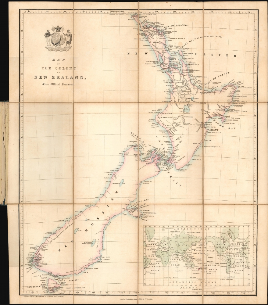
Map of the Colony of New Zealand from Official Documents.
1841 (undated) 17.25 x 13.25 in (43.815 x 33.655 cm) 1 : 3600000
1841 (undated) 17.25 x 13.25 in (43.815 x 33.655 cm) 1 : 3600000
Description
This is a rare c. 1841 Smith, Elder and Company map of New Zealand issued soon after it became a British colony. Reduced from John Arrowsmith's May 2, 1841 map of the same title, this is among the earliest maps of the New Zealand colony. This Smith, Elder and Company edition was published by the New Zealand Company, as part of their efforts to promote settlement in the colony. Despite being derived from the first issue of Arrowsmith's map, the present work predates most examples of the Arrowsmith, which had a very long publication history.
The New Zealand Company was originally founded in 1825 with little attention and no government support. Enter Edward Gibbon Wakefield, an aspiring politician. In 1830, having completed a three-year jail sentence for the abduction and forced marriage of 15-year-old heiress Ellen Turner, Wakefield immediately became active in the National Colonial Society and formed the New Zealand Association, hoping it would succeed where the New Zealand Company failed. He chaired its first meeting on May 22, 1837, but the association faced instant opposition from both the government and the missionary societies. By September 1837, discussions were already occurring to merge the New Zealand Association with the aforementioned New Zealand Company. The organizations failed twice to meet the requirements for a Royal Charter, but in 1839, the merged organizations formed the New Zealand Land Company.
A Closer Look
The map depicts both the North and South Islands, and labels several early settlements. The arms of the New Zealand Company adorn the title cartouche. An inset map of the world in the lower right corner contextualizes New Zealand's place on the globe. Arrowsmith's May 2, 1841, map provides the basis for the present work's geography. This map presents Wellington much more boldly than it had appeared on the Arrowsmith; reflecting its elevation to a capital by the directors of the New Zealand Company, in honor of the Duke of Wellington, in recognition of his support. New Plymouth appears here for the first time, as it was not noted on the Arrowsmith.The New Zealand Company
The New Zealand Company, which existed in the United Kingdom in the first half of the 19th century, focused on the systematic colonization of New Zealand. The Company followed the vision of Edward Gibbon Wakefield, who intended to create a new-model English capitalist society in the Southern Hemisphere.The New Zealand Company was originally founded in 1825 with little attention and no government support. Enter Edward Gibbon Wakefield, an aspiring politician. In 1830, having completed a three-year jail sentence for the abduction and forced marriage of 15-year-old heiress Ellen Turner, Wakefield immediately became active in the National Colonial Society and formed the New Zealand Association, hoping it would succeed where the New Zealand Company failed. He chaired its first meeting on May 22, 1837, but the association faced instant opposition from both the government and the missionary societies. By September 1837, discussions were already occurring to merge the New Zealand Association with the aforementioned New Zealand Company. The organizations failed twice to meet the requirements for a Royal Charter, but in 1839, the merged organizations formed the New Zealand Land Company.
The 'Tory', Buying Land, and the Treaty of Waitangi
That same year, the newly-formed Company sent Colonel William Wakefield, Edward Gibbon Wakefield's uncle, aboard the first of three vessels to buy land for the first British settlement in New Zealand. Wakefield arrived in mid-August and set about acquiring land from the Maori with the help of Dicky Barrett, a whaler and trader who had lived among the Maori since 1828. Wakefield eventually purchased 20 million acres of land after securing signatures and marks on parchment that were assumed to grant ownership. This land purchasing continued until the signing of the Treaty of Waitangi on February 6, 1840. This treaty made it illegal for anyone to purchase land from the Maori other than the British Crown, running directly counter to the Company's efforts to buy as much land from the Maori as possible, as cheaply as possible. By August 1841, the government and the Company reached an agreement in which some, but not all, of the land that the New Zealand Company had 'purchased' in 1839 could be resold by the Company.The Settlement of Wellington
The settlement of Wellington was not an easy venture. Surveyor-General William Mein Smith began surveying his chosen settlement site (on the opposite side of Fitzroy Bay from where William Wakefield wanted the settlement) in January 1840. Smith's chosen site was near arable land, but it was also in the middle of dense forest, scrub, flax, and swamp, and it was close to a river that was prone to flooding. Also, its nearest beach was so flat that it forced the arriving colonists, who disembarked only days after Smith began his work, to disembark 1600 meters from the shore. Smith's site was abandoned eight weeks later after a vote by the settlers, and the town was moved to Wakefield's preferred site on the southwest side of the harbor.Publication History and Census
This map was created and published by Smith, Elder and Company. Examples are cataloged in the OCLC as being part of the collections at the University of Auckland, the National Library of New Zealand, the State Library of New South Wales, the National Library of Australia, the Te Aka Matua Library at the Museum of New Zealand, and the University of Otago. It is rare on the private market.CartographerS
Smith, Elder, and Company (1816 - 1917) was a publishing firm based in London that was founded by two Scottish men: George Smith (1789 - 1846) and Alexander Elder (1790 - 1876). Founded in 1816, Smith, Elder and Company’s first three years in business were spent selling pens, paper, pencils, ink, account books, and other similar items, along with both new and used books, journals, and musical scores. A major portion of their clientele was officers from the East India Company, which significantly helped build the firm’s financial strength. Three years later the firm entered the publishing world when they released Sermons and Expositions on Interesting Portions of Scripture by John Morison. A third partner, Patrick Stewart, joined the company in 1824, and the company moved to Cornhill. The firm continued publishing small works, particularly editions meant to be bought as gifts, until 1843 when George Smith’s son, George Murray Smith (March 18, 1824 – April 6, 1901), who had joined the firm in 1838 and worked his way up through the ranks to become head of the small publishing arm of the business, agreed to publish the first volume of Modern Painters by John Ruskin, which launched a very lucrative thirty-year relationship between the publishing house and Ruskin. Other major successes followed, but very few would compare to George Murray Smith’s decision to publish Charlotte Brontë’s Jane Eyre, which created a deep, personal friendship between the publisher and author. Smith also managed to entice many renowned authors to publish with the firm, including Robert Browning, William Makepeace Thackeray, and Anthony Trollope. Smith, Elder, and Company began publishing their well-received literary journal The Cornhill in 1859, which published serialized novels by both Trollope and Thackeray in its first year. The first issue reportedly sold 120,000 copies. The firm continued to see success in the late 19th century. But, after Reginald Smith, George Murray Smith’s son-in-law, died on December 26, 1916, no one was left to continue running the company. All book rights and remaining stock were bought by John Murray in May 1917. More by this mapmaker...
Francis Paul Becker (fl. 1837 - 1861) was a British artist and engraver who founded F.P. Becker and Company. He also patented 'omnigraphy', a process by which individual letters were punched and not engraved into the plate. Learn More...
Aaron Arrowsmith (1750-1823), John Arrowsmith (1790-1873), and Samuel Arrowsmith. The Arrowsmith family were noted map engravers, publishers, geographers, and cartographers active in the late 18th and early 19th century. The Arrowsmith firm was founded by Aaron Arrowsmith, who was trained in surveying and engraving under John Cary and William Faden. Arrowsmith founded the Arrowsmith firm as a side business while employed by Cary. The firm specialized in large format individual issue maps containing the most up to date and sophisticated information available. Arrowsmith's work drew the attention of the Prince of Wales who, in 1810, named him Hydrographer to the Prince of Wales, and subsequently, in 1820, Hydrographer to the King. Aaron Arrowsmith was succeeded by two sons, Aaron and Samuel, who followed him in the map publication business. The Arrowsmith firm eventually fell to John Arrowsmith (1790-1873), nephew of the elder Aaron. John was a founding member of the Royal Geographical Society. The firm is best known for their phenomenal large format mappings of North America. Mount Arrowsmith, situated east of Port Alberni on Vancouver Island, British Columbia, is named for Aaron Arrowsmith and his nephew John Arrowsmith. Learn More...
Condition
Excellent. Dissected and laid on linen for folding, as issued, in original boards. Original wash color.
References
OCLC 949719967.