1873 Wheeler Map of Northern Arizona and Environs, Grand Canyon Region
NnwAZsUT-wheeler-1873$500.00

Title
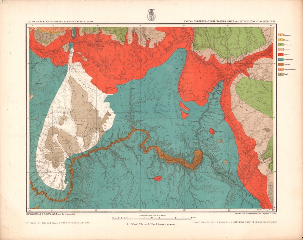
Parts of Northern and North Western Arizona and Southern Utah. Sheet No. 67.
1873 (undated) 17.25 x 21.5 in (43.815 x 54.61 cm) 1 : 506880
1873 (undated) 17.25 x 21.5 in (43.815 x 54.61 cm) 1 : 506880
Description
A beautifully chromolithographed geologic map of northern Arizona and environs, including the Grand Canyon, produced by the Wheeler Survey c. 1873 and published in the Topographical Atlas which summarized the survey's work.
A Closer Look
As the title indicates, coverage includes much of northern Arizona, along with parts of southwestern Utah. Vivid color illustrates different geological eras and layers according to a legend at right. Elevation, waterways (primarily the Colorado River and tributaries), and various other features such as springs, knolls, and recognizable rocks are indicated, including the Grand Canyon, very prominent on the lower half of the sheet. Trails used by the Navajo and Mormons are noted at right. Although settlement by Europeans and their descendants was limited in this region, several towns including St. George, Toquerville, and Virgin City (now just Virgin) appear in southern Utah.The Wheeler Survey, 1872 - 1879
One of the 'Four Great Surveys' of the American West, the expedition led by U.S. Army officer George Montague Wheeler was tasked with creating geologic and topographic maps of the territory west of the 100th meridian at the scale of eight miles to one inch. Like the other three 'great surveys' that took place around the same time, led by Clarence King (Fortieth Parallel Survey), John Wesley Powell (Green and Colorado Rivers, including the Grand Canyon), and Ferdinand Vandeveer Hayden (U.S. Geological and Geographical Survey of the Territories, focusing on the Yellowstone Region), the Wheeler Survey collected a wide range of information on Native American cultures (including early photographs), flora, fauna, and other topics in addition to its surveying work. Veterans of these expeditions went on to illustrious careers in the military, geology, cartography, photography, painting, and other fields. In 1879, Congress formally merged these projects to create the U.S. Geological Survey.Chromolithography
Chromolithography, sometimes called oleography, is a color lithographic technique developed in the mid-19th century. The process involved using multiple lithographic stones, one for each color, to yield a rich composite effect. Oftentimes, the process would start with a black basecoat upon which subsequent colors were layered. Some chromolithographs used 30 or more separate lithographic stones to achieve the desired product. Chromolithograph color could also be effectively blended for even more dramatic results. The process became extremely popular in the late 19th and early 20th centuries, when it emerged as the dominant method of color printing. The vivid color chromolithography produced made it exceptionally effective for advertising and propaganda imagery.Publication History and Census
This map was prepared by Grove Karl Gilbert, Arch R. Marvine, Edwin Eugene Howell, and George Montague Wheeler, based on surveys conducted in 1871 - 1873. It was lithographed by Weyss, Herman, and Lang, likely employees of Julius Bien, for publication in the work Topographical Atlas Projected to Illustrate United States Geographical Surveys West of the 100th Meridian of Longitude, published between 1876 and 1881. There are two highly similar printings of this map; one uncolored with explanatory notes in the bottom margin but without the information on rock layers and eras (Rumsey 2738.068) and the present chromolithographed printing. Regardless of printing, the map is independently cataloged by Brigham Young University, the University of New Mexico, the University of Wisconsin-Milwaukee, Princeton University, and the University of Michigan, while the entire Atlas is more widespread.CartographerS
George Montague Wheeler (October 9, 1842 - May 3, 1905) was a surveyor and cartographer best known for leading the U.S. Government's geographical surveys west of the 100th meridian, better known as the Wheeler Survey. Born in Massachusetts, Wheeler attended West Point and graduated near the top of his class in 1866. He joined the Army Corps of Engineers and was dispatched to the American West, before being chosen to lead the ambitious survey that came to be associated with his name, which lasted from 1872 to 1879. More by this mapmaker...
Grove Karl Gilbert (May 6, 1843 - May 1, 1918) was an American geologist who participated in early surveys of the American West. Born in New York, he attended the University of Rochester. He served as first geologist to George M. Wheeler's survey of the territory west of the 100th Meridian, and then joined John Wesley Powell's survey of the Green and Colorado River regions and the Rocky Mountains. These surveys were merged with the other two 'great surveys' of the American West to form the U.S. Geological Survey in 1879, whereupon Gilbert was appointed Senior Geologist. He spent the rest of his career and life with the USGS and was one of the most well-regarded geologists of his day, earning numerous awards and serving twice as President of the Geological Society of America. Learn More...
Edwin Eugene Howell (March 12, 1845 - April 16, 1911) was an American geologist and cartographer known for his high-quality raised relief maps. Born in New York, he attended the University of Rochester, where he studied with the geologist Henry A. Ward. Afterwards, he joined early surveys in the American West led by George Montague Wheeler and John Wesley Powell, two of the 'Four Great Surveys' that were joined to form the U.S. Geological Survey. Afterwards, he devoted his efforts to producing maps, including the aforementioned raised-relief maps, and also helped to found the Geological Society of America. Learn More...
Arch R. Marvine (fl. c. 1871 - 1874) was a geologist who joined early government surveys in the American West, predecessors to the U.S. Geological Survey, as a geological assistant. In the course of this work, he attained the title of Assistant Geologist Directing the Middle Park Division. No other information on his life or his subsequent career is available. Learn More...
The United States Geological Survey (1878 - Present), aka the U.S.G.S., is a scientific agency of the United States government, which was founded in 1879. USGS scientists study the landscape of the United States, its natural resources, and the natural hazards that threaten it. The organization has four major science disciplines: biology, geography, geology, and hydrology. It is a bureau of the United States Department of the Interior and is the department's only scientific agency. Learn More...
Source
Wheeler, G. M. et al, Topographical Atlas Projected to Illustrate United States Geographical Surveys West of the 100th Meridian of Longitude..., (New York: U.S. Army Corps of Engineers) 1876 - 1881.
Condition
Good. Uneven toning, creasing, and chips in margins and along edge.
References
Rumsey 2738.069. OCLC 367506357, 712789532.