This item has been sold, but you can get on the Waitlist to be notified if another example becomes available, or purchase a digital scan.
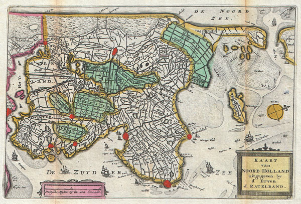
1747 La Feuille Map of Northern Holland
NoordHolland-ratelband-1747$112.50

Title
Kaart van Noord-Holland.
1747 (undated) 7 x 10.25 in (17.78 x 26.035 cm)
1747 (undated) 7 x 10.25 in (17.78 x 26.035 cm)
Description
A stunning map of the northern part of Holland or the Netherlands first drawn by Daniel de la Feuille in 1706. Oriented to the west. Covers from Amsterdam at the far right northward as far as Texel and southward as far as Enkhuizen. Features some offshore detail and several sailing ships plying the Zuyder Zee ( Zuiderzee ).Dutch language title cartouche in lower right quadrant. This is Paul de la Feuille's 1747 reissue of his father Daniel's 1706 map. Prepared for issue as plate no. 35 in J. Ratelband's 1747 Geographisch-Toneel.
CartographerS
Daniel de La Feuille (1640 - 1709) was born of Huguenot stock in Sedan (L'Ardennes), France. As a young man he apprenticed as a watchmaker. In 1663 La Feuille married Charlette Marlet, the daughter of a local carpenter. Twenty years later, in 1683, facing religious prosecution of Huguenots in France, the family fled to Amsterdam. By 1686 Daniel had become a burgher (citizen) of the city and established himself as an engraver, publisher, and art dealer. Not long after, in 1691, he was admitted into the Booksellers Guild. Though we are primarily concerned with his cartographic work here, his masterpiece is considered to be Devises et emblems, a collection of symbols and designs mostly likely intended as templates for silversmiths, engravers, and watchmakers. His cartographic work includes numerous individual maps and atlases, many of which continued to be published and republished well after his death in 1709. He was succeeded by his sons Jacob de la Feuille (1668 - 1719) and Paul de La Feuille (1688 - 1727). More by this mapmaker...
Johannes Ratelband (1715 - 1793) was a European map publisher based in Amsterdam. Ratelband is a rather obscure fellow, but is known to have published a series of European maps and views in association with the La Feuille family. Learn More...
Source
Geographisch-Toneel Of uitgezochte Kaarten, Tot gemak der Officieren, Reisigers en Liefhebbers; Behelsende alle de generale Kaarten ..., (1747 J. Ratelband issue.)
Condition
Very good condition. Minor discoloration and wear along original foldlines. Original platemark visible.