This item has been sold, but you can get on the Waitlist to be notified if another example becomes available, or purchase a digital scan.
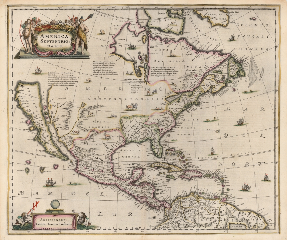
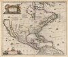
1646 Jansson Map of North America (California as an Island)
NorthAmerica-jansson-1636$3,250.00

Title
America Septentrionalis.
1636 (undated) 18.25 x 21.75 in (46.355 x 55.245 cm) 1 : 21000000
1636 (undated) 18.25 x 21.75 in (46.355 x 55.245 cm) 1 : 21000000
Description
This is a beautiful old-color example of Jan Jansson's 1636 map of North America. It is the first folio map to focus on North America specifically after De Jode's 1593 map, and as such features several cartographic primacies. It is the first general Dutch map of North America to depict a Great Lake connected to the St. Lawrence, and the first obtainable Dutch atlas map of North America to embrace the theory of Insular California. Map historian Carl Wheat considered the many accurate depictions of America's fauna on the map to 'represent its most authentic information, so far as what is now western United States is concerned'.
The Island of California
Jansson's map is the first detailed Dutch map of America to feature an insular California after the unacquirable 1624 Goos T'Noorder deel van West-Indien. It is thus one of the first obtainable maps to incorporate California-as-an-island myth, and arguably the most beautiful, bearing perhaps the clearest representation of that cartographic trope. Jansson's map derives the toponymy and general geographic form of insular California from the 1625 Briggs map, The North Part of America. It also includes text, translated from the Briggs, recounting the capture by Dutch privateers of a Spanish ship carrying a map of the island of California. This legend, including even the dimensions of the legendary island, contributed significantly to cementing this enduring cartographic myth.State of the Art Southern Geography
The mapping of Mexico and Central America closely adheres to the 1630 Gerritz / De Laet Nova Hispania. Likewise, the map's South American geography is influenced by Hessel Gerritsz's 1630 Venezuela and Guaiana. As official cartographer to Dutch East India and Blaeu's senior, Gerritsz's information formed the basis of the most authoritative Dutch maps of the period.The Southwest and the Rio del Norte
East of California (on the mainland) are the Hopi Pueblos (Pueblos de Moqui) and an indication of the Spanish province of New Mexico. A city marked Real de Nueva Mexico appears on the east bank of the Rio del Norte, roughly corresponding to Santa Fe. As would be the case until the corrections of the 1687 Coronelli-Nolin map of New Mexico, this river flows not to the Gulf of Mexico but westwards to the Sea of California (Mar Vermio). A vast, imaginary mountain range wrapping from Virginia to the Gulf of Mexico, thus enclosing Spanish Florida, creates expansive watershed emptying into the Gulf of Mexico via a Baya del Sp. Santo. The mountain range curtails even the largest of these rivers, none of which can be construed as an analog to the Mississippi, which would not appear on a map until the 1683 Hennepin.The Great Lakes - French Influence
This is the first map of America to depict a definite Great Lake attached to the St. Lawrence. The lake here is likely Lake Ontario, termed here Lac des Iroquois. Further to the east Lac de Champlain, more commonly associated with Lac des Iroquois, is shown and named, also connected to the St. Lawrence. The appearance of these French placenames suggests an uncharacteristic familiarity with and acceptance of Samuel de Champlain's cartography. Generally, the Dutch maps of the 17th century lagged behind the French with regard to the Great Lakes.The North
The American northwest beyond the island of California is left incomplete and obscured behind the cartouche. To the east, Canada, the Maritimes, and Hudson's Bay are depicted after the fashion of Luke Fox(e)'s 1635 polar projection, despite having ignored his delineation of California. Like the Fox, Jansson's map includes sufficient openings in the coastline to encourage speculation on passage to the Pacific from Hudson's Bay.The Colonial Coastline
The North American East Coast is divided by the Dutch and English north of Spanish Florida, which holds sway as far north as Lake May and the St. Mary's River. The Gulf Coast, the Caribbean, and the shape of Florida derive from Hessel Gerritz's 1631 De Eylanden Ende Vastelanden Van Westindien op de Noordzee. That chart did not include the interior detail revealed here, which did appear on the 1630 Gerritz / De Laet Florida et Regiones Vicinae. The Virginia colony embraces Georgia, the Carolinas, and the western shores of the Chesapeake. The apocryphal lakes shown here amongst the Apalatcy Montes were preserved in Gerritz's Florida, derived from the 1591 De Bry / Le Moyne map. The New Netherlands - here Latinized as Novum Belgium - include modern-day Delaware, Pennsylvania, New Jersey, and New York. Fort Orange (Albany) is marked and named. Manhates (Manhattan) is also named, as is the Hudson (Noort R.). New England sports a recognizable Cape Cod, Narragansett Bay, and an early Boston (Bristow).Buss Island
Although Jansson's map does not perpetuate the Zeno geography that dominated earlier maps of the North Atlantic, those waters are not devoid of phantom islands. One such, Buss Island, appears here. This was first recorded by sailors on the 1578 third Martin Frobisher expedition. Frobisher sailed on the Emanuel, a class of ship known as a busse, hence the name. They placed the island between Ireland and Zeno's fraudulent Frisland. Frobisher's 'Frisland' was southern Greenland, and what he thought was 'Greenland' was in fact Baffin Island. Furthermore, Buss Island itself was the result of a mirage, rather than actual land. Despite this, writing in 1671, a mysterious figure named Thomas Shepard claimed that Buss Island was not only real, but that he explored and mapped it. In 1745, it was proposed that the island was once there but sank - pointing out supposedly shallow seas in the area - earning it the name 'Sunken Land of Buss'. In 1818, its existence was disproved by John Ross, who during his first Arctic expedition, plumbed the waters of its alleged location to a depth of 180 fathoms (330 m) finding no bottom.A Superb Engraving
Of the Dutch atlas maps focusing specifically on North America, this is arguably the most beautiful. In addition to the horses and game animals praised by Wheat, the seas are peppered with sea monsters and sailing ships. The title cartouche is topped with lizards, snakes, birds, and a tortoise and flanked by armed indigenous warriors. The imprint cartouche in the lower left is topped with an orb, and flanked by two mer-putti - one of whom is sighting the sun with a cross-staff.Publication History and Census
This map was engraved by Jan Jansson as early as 1636 for inclusion in Hondius atlases, in which it appeared in its first state lacking the mapmakers imprint. Beginning in 1647 Jansson added his own imprint (as here) and continued to publish the work in his atlases. Examples without verso text have appeared tipped into other 17th century atlases, such as those of Nicolas Visscher - suggesting the map was also sold as a separate issue. Around 1694, Valk and Schenk acquired the plate and added their own imprint. In its various editions, this map is well represented in institutional collections. Examples appear on the market from time to time, although examples of this quality with original color grow increasingly scarce.CartographerS
Jan Jansson or Johannes Janssonius (1588 - 1664) was born in Arnhem, Holland. He was the son of a printer and bookseller and in 1612 married into the cartographically prominent Hondius family. Following his marriage he moved to Amsterdam where he worked as a book publisher. It was not until 1616 that Jansson produced his first maps, most of which were heavily influenced by Blaeu. In the mid 1630s Jansson partnered with his brother-in-law, Henricus Hondius, to produce his important work, the eleven volume Atlas Major. About this time, Jansson's name also begins to appear on Hondius reissues of notable Mercator/Hondius atlases. Jansson's last major work was his issue of the 1646 full edition of Jansson's English Country Maps. Following Jansson's death in 1664 the company was taken over by Jansson's brother-in-law Johannes Waesberger. Waesberger adopted the name of Jansonius and published a new Atlas Contractus in two volumes with Jansson's other son-in-law Elizée Weyerstraet with the imprint 'Joannis Janssonii haeredes' in 1666. These maps also refer to the firm of Janssonius-Waesbergius. The name of Moses Pitt, an English map publisher, was added to the Janssonius-Waesbergius imprint for maps printed in England for use in Pitt's English Atlas. More by this mapmaker...
Henricus Hondius II (1597 – August 16, 1651) was a Dutch engraver, cartographer and publisher. The son of the cartographer Jodocus Hondius, Henricus took over the business after father died in 1612, co-ran the business with his brother Jodocus II. In 1628 Henricus partnered with Jan Janssonius and together they continued the business, with Jansson’s name appearing on the Atlasas co-publisher after 1633. Eventually, about 50 editions of the Atlas were released in the main European languages. In the Islamic world, the atlas was partially translated by the Turkish scholar Katip Çelebi. The series is sometimes called the 'Mercator/Hondius/Jansson' series because of Jansson's later contributions. Learn More...
Hessel Gerritsz (1581 – September 4, 1632) was a Dutch engraver, cartographer, and publisher active in Amsterdam during the late 16th and early 17th centuries, among the most preeminent Dutch geographers of the 17th century. He was born in Assum, a town in northern Holland in 1581. As a young man he relocated to Alkmaar to accept an apprenticeship with Willem Jansz Blaeu (1571-1638). He followed Blaeu to Amsterdam shortly afterwards. By 1610 he has his own press, but remained close to Blaeu, who published many of his maps. In October of 1617 he was appointed the first official cartographer of the Vereenigde Oost-Indische Compagnie (Dutch East Indian Company) or VOC. This strategic position offered him unprecedented access to the most advanced and far-reaching cartographic data of the Dutch Golden Age. Unlike many cartographers of his period, Gerritsz was more than a simple scholar and showed a true fascination with the world and eagerness to learn more of the world he was mapping in a practical manner. In 1628 he joined a voyage to the New World which resulted in the production of his seminal maps, published by Joannes de Laet in his 1630 Beschrijvinghe van West-Indien; these would be aggressively copied by both the Blaeu and Hondius houses, and long represented the standard followed in the mapping of the new world. Among his other prominent works are a world map of 1612, a 1613 map of Russia by the brilliant Russian prince Fyodor II Borisovich Godunov (1589 – 1605), a 1618 map of the pacific that includes the first mapping of Australia, and an influential 1630 map of Florida. Gerritsz died in 1632. His position with the VOC, along with many of his printing plates, were taken over by Willem Janszoon Blaeu. Learn More...
Source
Jansson, J., Atlas Novus, (Amsterdam) 1647.
Condition
Excellent. Mended pinholes to corners well away from printed image, else fine with original outline color.
References
OCLC 9141824. Rumsey 11755.124 (added to Visscher atlas). Wheat, C. I., Mapping of the Transmississippi West, 1540 – 1861, Volume 1, #45. Burden, P., The Mapping of North America, 245 state 2. McLaughlin, G., The Mapping of California as an Island: An Illustrated Checklist, #6 state 2.