This item has been sold, but you can get on the Waitlist to be notified if another example becomes available, or purchase a digital scan.
1845 Tanner Map of North America
NorthAmerica-tanner-1845$275.00

Title
North America.
1845 (dated 1836) 14 x 11 in (35.56 x 27.94 cm) 1 : 23300000
1845 (dated 1836) 14 x 11 in (35.56 x 27.94 cm) 1 : 23300000
Description
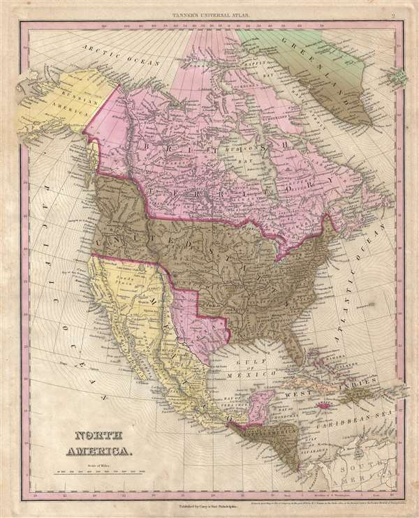
This is Tanner's rare 1845 map of North America showing the Republic of Texas at its fullest. The map cover all of North America, from the Arctic Circle, Greenland, and Alaska, to Mexico, Central America, the Caribbean, and the West Indies Islands. It illustrates a period of shifting political alliances, territorial expansion, and increasing conflict. One year after this map was issued, the Mexican-American War (1846 – 1848) would break out, leading to one of the largest redistributions of political power in 19th century American history.
Issued at the tail end of the Republic of Texas Period (1836 – 1845) and on the cusp of Texas's annexation into the United States at the 28th State (December 29, 1845), this is one of the few maps to illustrate the full territorial claims of the Republic of Texas. These early claims extend west as far as the Rio Grand and the Rio del Norte and north along a narrow 'stovepipe' as far as modern-day Wyoming. While Texas is clearly defined here as separate from Mexico and according separate coloration similar to Canada, it is noteworthy that Tanner does not give Texas a dark red border that signifies a separate country – thus indicative of Texas's ambiguous state at the time as nominally independent but not recognized as such by most world powers.
This map is also significant for Tanner's incorporation of Jedediah Smiths cartography. Jedediah Smith (1799 - 1831) was an American born trapper, hunter, explorer, fur trader, and trail blazer active in the early part of the 19th century. Smith is an incredibly important but little-known figure who, in the years between the Lewis and Clark expedition and Fremont's explorations, explored and trail blazed much of the American West. Smith died before he could promote his cartographic advances, but his manuscript material, now lost, fell into the hands of David Burr and other cartographers, like Gallatin and Tanner, who first brought his discoveries to the general public. When discussing this map in his Mapping the Transmississippi West, Wheat writes,
This map was issued by Carey and Hart in Philadelphia for and published as plate no. 2 in the 1845 edition of Tanner's New Universal Atlas. The plate was later revised and updated for publication in Mitchell's New Universal Atlas, and thus provided the underlying cartography for one of the longest running and most widely distributed American maps of North America to appear in the 19th century.
Issued at the tail end of the Republic of Texas Period (1836 – 1845) and on the cusp of Texas's annexation into the United States at the 28th State (December 29, 1845), this is one of the few maps to illustrate the full territorial claims of the Republic of Texas. These early claims extend west as far as the Rio Grand and the Rio del Norte and north along a narrow 'stovepipe' as far as modern-day Wyoming. While Texas is clearly defined here as separate from Mexico and according separate coloration similar to Canada, it is noteworthy that Tanner does not give Texas a dark red border that signifies a separate country – thus indicative of Texas's ambiguous state at the time as nominally independent but not recognized as such by most world powers.
This map is also significant for Tanner's incorporation of Jedediah Smiths cartography. Jedediah Smith (1799 - 1831) was an American born trapper, hunter, explorer, fur trader, and trail blazer active in the early part of the 19th century. Smith is an incredibly important but little-known figure who, in the years between the Lewis and Clark expedition and Fremont's explorations, explored and trail blazed much of the American West. Smith died before he could promote his cartographic advances, but his manuscript material, now lost, fell into the hands of David Burr and other cartographers, like Gallatin and Tanner, who first brought his discoveries to the general public. When discussing this map in his Mapping the Transmississippi West, Wheat writes,
>There is some question whether Tanner or Gallatin should be accorded the palm for being the first to make Jedediah Smith known to his countrymen. This Tanner map was republished at least to 1845, but since the Tanner 'Mexico' of 1834 retained the earlier forms and since no map of this type with date earlier than 1836 has been discovered, Gallatin and Tanner must both be given the prize. It is unfortunate that Warren was ignorant of this map. It was originally brought to my attention by Charles M. Camp.The map further illustrates American claims to British Columbia, a conflict between British American and the United States over the northern limits of Oregon Territory, known known as the Oregon Boundary Dispute or, more commonly for its Pro-American slogan '54-40 or Fight!' One year after this map was issued the Oregon Question was finally resolved by the Oregon Treaty. The 1846 Oregon Treaty established the border between British North America and the United States along the 49th parallel until the Strait of Georgia, where the marine boundary curved south to exclude Vancouver Island and the Gulf Islands from the United States.
This map was issued by Carey and Hart in Philadelphia for and published as plate no. 2 in the 1845 edition of Tanner's New Universal Atlas. The plate was later revised and updated for publication in Mitchell's New Universal Atlas, and thus provided the underlying cartography for one of the longest running and most widely distributed American maps of North America to appear in the 19th century.
CartographerS
Henry Schenck Tanner (1786 - May 18, 1858) was one of the preeminent American map engravers and publishers of the early 19th century - what is considered to be the "Golden Age of American Map Publishing". Born in New York City but based in Philadelphia, Tanner's forty plus year career was almost entirely focused on cartographic work. His earliest map work appears in conjunction with another important map publisher, John Melish. Early in his career, Tanner partnered with his brother Benjamin, to engrave extensively for Melish as well as other Philadelphia publishers including Lucas Fielding (Baltimore), A. Bourne, Jason Torey, Samuel Harrison, and Samuel Lewis, among others. In 1818 Tanner convinced his fellow publishers and partners to finance the compilation of a New American Atlas. The atlas was sold by subscription and slowly emerged between 1819 and 1823. The New American Atlas, possibly the pinnacle of 19th century American cartography and was commended in its day as "one of the most splendid works of the kind ever executed in this country". It was subsequently republished in several updated editions until about 1839. Tanner had by this time become the most active and influential map publisher in the United States. Around 1832, recognizing the market for a less cost prohibitive atlas, Tanner began work on the smaller format New Universal Atlas. This popular and important atlas went through numerous editions before being bought out by Carey and Hart, and then, in 1846, by S. A. Mitchell, who would rise to become the preeminent publisher of the next generation. In addition to these important atlases, Tanner also issued numerous extremely important and influential travelers guides, state maps, wall maps, and pocket maps. He should not be confused with his brother, also an America map engraver, the New Yorker Benjamin Tanner. More by this mapmaker...
Edward L. Carey (April 7, 1805 - June 16, 1845) was an American publisher, aesthete, art lover, and the co-founder, along with Abraham Hart, of the prominent publishing firm Carey and Hart. Carey was the son of American publisher Mathew Carey (1760 - 1839) and Bridget Flahaven Carey. He initially worked for his brother, Henry Charles Carey who, along with relative and partner Isaac Lea, purchased their father's publishing house in 1822, rebranding it as Carey and Lea. Eventually, Edward Carey became a junior partner in the firm, acquiring half of the shares belonging to Lea, and the imprint briefly changed to Carey, Lea, and Carey. On November 1, 1829, Edward Carey detached himself from his brother's firm and formed a partnership with Abraham Hart (1810 - 1885), an employee of Carey, Hart, and Carey. This firm, known as Carey and Hart, was successful for twenty-five years, publishing works by Henry Wadsworth Longfellow, William Cullen Bryant, and Eliza Leslie. Carey suffered from declining health during the last three years of his life. According to William Gilmore Sims, Carey died 'after suffering for some years from a tedious affliction of the spine.' Carey died on June 16, 1845 at the age of 40. Before his death, he was elected President of the Academy of Fine Arts, but declined the position due to his health. Learn More...
Abraham Hart (December 15, 1810 - July 22, 1885) was an American publisher of Jewish-Dutch descent based in Philadelphia. As a boy, Hart became an employee of the publishing firm Carey, Lea, and Carey. In 1829, when Edward Carey (1805 - 1845) left his older brother Mathew Carey's firm, Edward and Hart joined forces, forming Carey and Hart. This firm became very well-known and was successful for twenty-five years, publishing works by Henry Wadsworth Longfellow, William Cullen Bryant, and Eliza Leslie. Hart married Rebecca Cohen Isaacks in 1831. Carey died at the age of 40 in 1845, but Hart continued the publishing firm until he retired in 1854, which marked the end of the Carey and Hart imprint. After retiring, Hart involved himself with industrial enterprises, and served both the Centennial Button-hole Machine Company and the American Button-hole Machine Company in an executive capacity. Hart was also an active member of the Jewish community in Philadelphia, serving for a time as president of the Jewish Congregation Mickvéh Israel, and assisting in Jewish educational and charitable enterprises. Learn More...
Condition
Very good.
References
Rumsey 5363.003.