This item has been sold, but you can get on the Waitlist to be notified if another example becomes available, or purchase a digital scan.
1795 Lewis and Carey: First American Map of North Carolina
NorthCarolina-careylewis-1795$475.00

Title
The State of North Carolina from the best Authorities etc.
1795 (undated) 11.5 x 19 in (29.21 x 48.26 cm) 1 : 1330560
1795 (undated) 11.5 x 19 in (29.21 x 48.26 cm) 1 : 1330560
Description
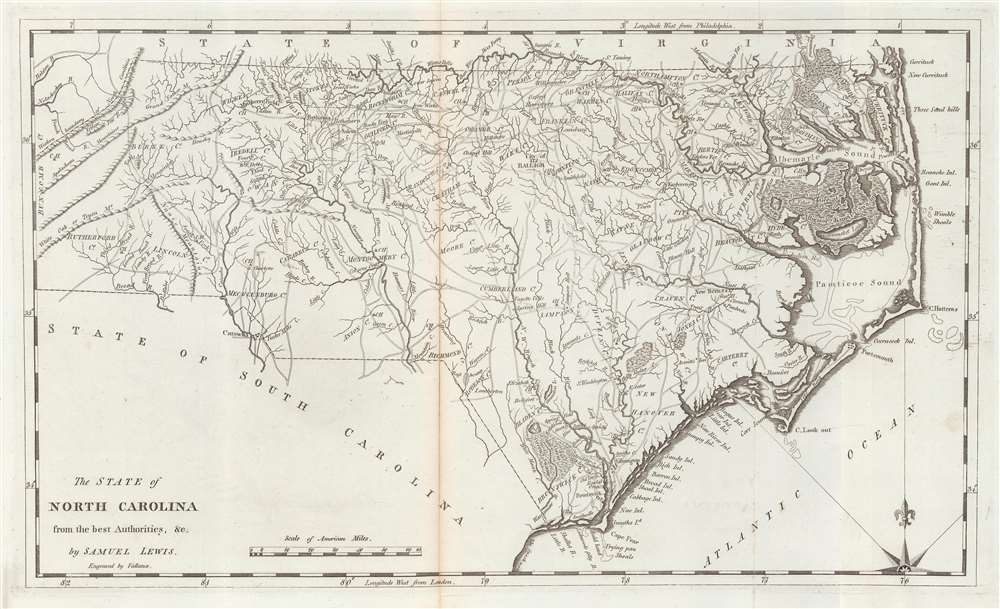
This is a 1795 first state example of the Samuel Lewis map of North Carolina, the earliest specific map of that state printed in the United States. It is also one of the few maps to show the Moravian Settlement of Wachovia, near modern-day Winston-Salem.
A Closer Look
Depicting from the Appalachian Mountains to the Outer Banks, cities and towns are labeled, including Raleigh, Wilmington, and New Bern. Albemarle and Pamlico ('Pamticoe') Sounds are identified along with numerous islands in the outer banks. Two swamps appear along the coastline, the 'Great Alligator Dismal Swamp' and the 'Great Dismal Lebanon Swamp'.The Moravian Community of Wachovia
The area around present-day Forsyth County (Winston-Salem) is highlighted with a dotted line, reflecting the boundaries of the Moravian Community of Wachovia. Wachovia was founded in 1753 when the Moravian Church acquired a 100,000-acre tract in what is now Forsyth County from Lord Granville. They built their settlement around the rough agricultural town of Bethabara (Winston-Salem). Bethabara grew significantly during the French and Indian War (1754 - 1763), and in 1766, the town of Salem, intended to be the permanent county seat, was established. Both Bethabara and Salem, as well as the nearby town of Bethania, are noted here - this being one of the few contemporaneous maps to show the settlement.Publication History and CensusThis map was created by Samuel Lewis, engraved by John Vallance, and published by Matthew Carey in his Carey's General Atlas. The first state, of which this example is representative, can be distinguished by the lack of county borders (Williams and Johnson). We note two examples of the separate map cataloged in OCLC: Rice University and the Bayerische Staatsbibliothek.CartographerS
Samuel Lewis (c. 1754 - 1822) was an American engraver, cartographer, draftsman, and geographer active in Philadelphia in the first of the 19th century. Though is place of birth is uncertain, most agree that Lewis emigrated from Dublin, Ireland, in the late 18th century. Lewis' earliest cartography work was produced in partnership with the well-known Philadelphia publishers Matthew Carey and Henry Schenk Tanner. In 1804, with the intention of republishing high quality English maps in the United States, Lewis partnered with the eminent British map publisher Arron Arrowsmith. Their first joint publication was A New and Elegant General Atlas, but many others followed including an American edition of Arrowsmith's important double hemisphere wall map of the world. Arrowsmith also worked with Jedidiah Morse, among other important American cartographers of the period. Ralph Brown considers Lewis to be "the most enterprising commercial map-maker of the period … " Lewis is best known for his map related to the expedition of Meriwether Lewis (no relation) and William Clark. In 1814 Lewis, copying directly from William Clark's manuscript, issued A Map of Lewis and Clark's Tracks across the Western Portion of North America. This important document was the first published map derived from the Lewis and Clark Expedition and profoundly transformed the cartography of the American northwest. Samuel Lewis of Philadelphia should not be confused with Samuel Lewis of London, another cartographer active during roughly the same period. More by this mapmaker...
John Vallance (1770 - June 14, 1823) was a Philadelphia based engraver active in the late 18th and early 19th centuries. Vallance was born in Glasgow, Scotland. Some scholars claim he apprenticed under Philadelphia engraver James Trenchard, but the dates don't work, as Vallance moved to the United States at 21, already an master engraver. At 21, in the year 1791, Vallance moved to Philadelphia and immediately partnered with James Thacakara, his wife's (a Trenchard?) uncle, establishing the imprint of Thackara and Vallance. The firm completed numerous significant cartographic projects, including maps for Andrew Ellicott, John Melish, Henry S. Tanner, and Reading Howell. Vallance later partnered with Henry Schenck Tanner (1786 - May 18, 1858) and Francis Kearney, forming Vallance, Kearney and Co. Vallance, working with Thackara, produced some of the most important early maps of Washington D.C., engraved early Continental Currencies, and worked on Dobson's Encyclopedia. In addition to his cartographic work, Vallance was also one of the founding members of the Philadelphia based Association of Artists in America. Learn More...
Matthew Carey (January 28, 1760 - September 16, 1839) was a Dublin born publisher who established himself in Philadelphia in the late 18th and early 19th century. A young man of socially progressive views, Carey's first known publication, produced when he was but 17 years old, was a pamphlet criticizing dueling. Another pamphlet, issued in the same year, attacked the Irish penal code. Shortly afterwards, in 1779, legal issues, possibly arising from his liberal political activism, forced Carey to flee to Paris. In Paris, Carey had the good fortune to befriend the visiting American diplomat and founding father, Benjamin Franklin (1706 - 1790). As an Irishman chafing under the rule of England, Carey sympathized with and admired the American revolutionary. The liberally minded pair struck up a lifelong friendship and Carey was hired to work at Franklin's press in Passy, France. A year later, Carey returned to Ireland and resumed his politically provocative publishing career with The Freemans's Journal and The Volunteer's Journal. It didn't take long for political pressure to once again force Carey from Ireland - this time to America (1784). Although largely without funds, Carey convinced Gilbert du Motier, Marquis de Lafayette (1757 - 1834), who he knew from Franklin's Paris circle, to lend him funds to establish a new publishing concern in Philadelphia. Despite this loan, Carey's firm remained under financed and opened on a shoestring budget. It was most likely his limited budget that led Carey to some of his most important publishing innovations. At the time cartographic publishing was dominated by large printing houses in London and Paris where most, if not all, of the work was completed in house. Without the finances to emulate this large publishing houses, Carey was forced to outsource much of his publishing work. This set the stage for subsequent American publishers who, in order to compete effectively with European firms, relied on an often bewildering network of alliances and collaborations. Carey was also a master of republishing many of his own maps in multiple different atlases and formats to maximize their profitability. His most important work is without a doubt the 1795 issue of the American Atlas the first atlas to be published in America. Carey died in 1839 but was succeeded by his son Henry Charles Carey (1793 - 1879) who, in partnership with his brother-in-law Isaac Lea (1792 - 1886), published numerous important maps and atlases under the Carey and Lea, Lea Brothers, and Lea and Blanchard imprints. Learn More...
Source
Carey, M., Carey's General Atlas, (Philadelphia: Carey) 1796.
Condition
Good. Centerfold split repaired and reinforced on verso.
References
Rumsey 2542.014. Wheat, J.C. and C.F. Brun, Maps and Charts Published in America Before 1800: A Bibliography. Second Revised Edition, No. 581. OCLC 1013397355, 163341046. Williams, Gregory W. and Allen S. Johnson, Tar Heel Maps: Colony and State, 1590 - 1995.