This item has been sold, but you can get on the Waitlist to be notified if another example becomes available, or purchase a digital scan.
1900 Donaldson Smith Map of Somalia, Ethiopia, Kenya, Uganda
NorthEastAfrica-donaldsonsmith-1900$325.00

Title
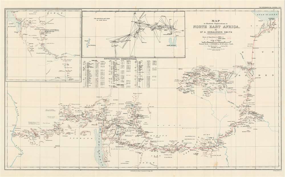
Map to illustrate Explorations in North East Africa.
1900 (dated) 19 x 31.25 in (48.26 x 79.375 cm) 1 : 2000000
1900 (dated) 19 x 31.25 in (48.26 x 79.375 cm) 1 : 2000000
Description
This is a 1900 Arthur Donaldson Smith map of East Africa. The map depicts from the Gulf of Aden south into modern-day Ethiopia and then west across modern-day Kenya and Uganda to the Nile River. Red lines trace Donaldson Smith's two expeditions through the region, with a dotted line following his 1894 - 1895 expedition and a solid line highlighting his route in 1899 - 1900. Locations along both routes are labeled, and Donaldson Smith provides dates when his party arrived at certain places, allowing the viewer to follow both expedition's progress across the continent. An inset map of the 1895 expedition's path south from Lake Rudolf is situated in the upper left corner next to a triangulation survey of most of the territory between Lake Rudolf and the Nile River. A chart of Donaldson Smith's astronomical observations during both expeditions appears below the inset devoted to the triangulation survey.
Donaldson Smith's Expeditions
His first expedition explored an incredible amount of territory not yet explored by Europeans and reached Lake Rudolf (today known as Lake Turkana). He elected to travel down the Mela River to the coast but promised himself that he would return to explore the region between Lake Rudolf and the Nile River. During the 1899 expedition, he achieved his goal of exploring that territory between Lake Rudolf and the Nile, and successfully mapped over 500 miles of territory new to European knowledge. The 1899 expedition reached Fort Berkeley, an English outpost on the Nile, before taking boats to Cairo.Publication History and Census
This map was created by Arthur Donaldson Smith, lithographed by Francis Sidney Weller, and published by the Royal Geographical Society in the December 1900 edition of The Geographical Journal. One example is catalogued in OCLC and is part of the institutional collection at The British Library.CartographerS
Arthur Donaldson Smith (April 27, 1866 - February 19, 1939) was an American physician, explorer, and hunter. Smith was born in Andalusia, Pennsylvania. He attended the University of Pennsylvania and graduated in 1885. After graduating, he immediately entered medical school at the University of Pennsylvania and received his medical degree in 1889. He inherited a fortune in 1892 and immediately gave up practicing medicine and set off on expeditions. Smith led a geological expedition sponsored by the Royal Geographical Society to Lake Rudolph (now Lake Turkana) in 1894 and 1895. Smith then worked as a war correspondent during the Tirah campaign in India in 1897. Then, in 1899, he returned to East Africa and explored from Lake Rudolph to the Nile River, a distance of 500 miles through territory where no white man had ever set foot. After he returned to the U.S., Smith gave several lectures and was given several prestigious awards. He then entered the U.S. consular service and was stationed throughout Central America and the Far East. Smith served in the U.S. Army as a Captain in the Medical Corps from November 16, 1917 until December 4, 1918. After the war, Smith opened a medical practice in Roulette, Potter County, Pennsylvania, and lived in Philadelphia. He retired after several years and moved to St. Petersburg, Florida. He never married. More by this mapmaker...
Edward Weller (July 1, 1819 - 1884) was a cartographer and engraver based in London. Weller was a nephew of another well-known map publisher Sidney Hall (1788 - 1831), who gave him 50 Pounds to pay his apprenticeship fees. He engraved for many prominent mapmakers and was active enough in the community to be recommended for membership to the Royal Geographical Society in 1851 on the recommendation of John Arrowsmith, among others. He eventually inherited the Sidney Hall map business which led him to follow Arrowsmith as the unofficial geographer to the Royal Geographical Society. Weller was among the first map printers in London to embrace lithography. His best known work appears in Cassell's Weekly Dispatch Atlas, published in monthly segments for subscribers of the 'Weekly Dispatch' newspaper. This collection of maps eventually grew to include much of the known world. Published in various editions from 1855 through the early 1880s. Weller died in May of 1884, leaving behind a successful business and an unhappy widow. His son, Francis Sidney Weller (1849 - 1910), followed in his father's footsteps and continued the family map business. The atlas Mackenzie's Comprehensive Gazetteer of England and Wales was published in 1894 and bore F. S. Weller's signature on the maps. Learn More...
Royal Geographical Society (fl. 1830 - present) is a British Society established in 1830 to promote geographical science and exploration. Originally titled the "Geographical Society of London", the RGS received its royal charter from Queen Victoria in 1859 shortly after absorbing several similar but more regional societies including the African Association, the Raleigh Club and the Palestine Association. The RGS sponsored many of the most important and exciting voyages of exploration ever undertaken, including the exploration of Charles Darwin, David Livingstone, Robert Falcon Scott, Richard F. Burton, John Speke, George Hayward, H. M Stanley, Ernest Shackleton and Sir Edmond Hillary. Today, the RGS remains a leading global sponsor of geographical and scientific studies. The Society is based in Lowther Lodge, South Kensington, London. Learn More...
Source
Donaldson Smith, A. 'An Expedition Between Lake Rudolf and the Nile'. The Geographical Journal Vol. 16, No. 6 (London: Royal Geographical Society) 1900.
Condition
Very good. Light wear along original fold lines. Blank on verso.
References
OCLC 556280731.