
This item below is out of stock, but another example (left) is available. To view the available item, click "Details."
Details
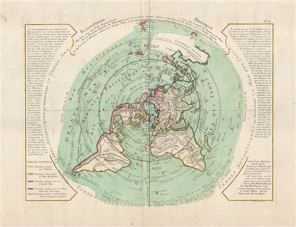
1781 Buache de Neuville Map of the World on Polar Projection (Arctic)
1781 (dated) $1,200.00
1781 Buache de Neuville Map of the World on Polar Projection (Arctic)
NorthernHemisphere-buache-1781$600.00

Title
Planisphere Physique.
1781 (undated) 14 x 17.5 in (35.56 x 44.45 cm) 1 : 60000000
1781 (undated) 14 x 17.5 in (35.56 x 44.45 cm) 1 : 60000000
Description
An exceptionally bright and beautiful c. 1781 Philippe Buache map of the world presented on an unusual polar projection rendered from the North Pole. The map covers from the North Pole Arctic region south beyond Tasmania (Van Diemen's Land) to include parts of New Zealand and even Cap de la Circoncision (Bouvet Island). Color coding highlights different types of terrain with a key in the lower left quadrant.
This curious projection has its origins in a 1752 essay presented by Philippe Buache to the Royal Academy of Sciences in Paris. This paper, Essai de Geographie Physique…, argued that the Earth's great river basins are defined by major mountain ranges, many of which extend beneath the oceans. The map's delineation of physical geography, both on the surface and below the sea support this theory and, true to form, Buache has added additional heretofore unknown mountain ranges where necessary. Some of these include speculative mountainous regions in the northern Sahara, bisecting central India, along the Orinoco basin, and connecting the islands of the Pacific.
Additional elements of interest include various pre-Cook notions of world geography. Among these is an uncertain mapping of eastern Australia connecting it to New Guinea and some smaller Melanesian islands identified here as Terre du St. Espirit, in fact the New Hebrides mis-mapped by the near insane 17th century Portuguese navigator Pedro Fernandes de Queiros.
Buache also includes a magnificent inland sea, called the Sea of the West or in this case the Mer de L'Ouest, in the northwestern part of the America. This body of water, alternatively called the Sea of the West or Baye de l'Ouest, was speculated by Philippe Buache and De l'Isle in the early 18th century based upon wishful thinking, American Indian stories, and the somewhat questionable 16th century explorations of Juan de Fuca. Here Buache gives the Mer de l'Ouest its fullest expression, though he specifically does not connect it to either the factual network of lakes and rivers extending westward from the Hudson Bay or to the speculative De Fonte network just to the north.
Extensive text expounding on Buache's geographical theories surround the map. Additional text describes the voyages of Bouvet de Lozier (1738-9) and Abel Tasman (1603-1659), both of which are marked on the map proper.
This map was originally issued in 1752. The present example was drawn from the 1781 Jean-Nicholas Buache de Neuville and Jean-Claude Dezauche's Atlas Geographique.
CartographerS
Phillipe Buache (February 7, 1700 - January 24, 1773) was a late 18th century French cartographer and map publisher. Buache began his cartographic career as the workshop assistant and apprentice to the important and prolific cartographer Guillaume de L'Isle. Upon De L'Isle's untimely death, Buache took over the publishing firm cementing the relationship by marrying De L'Isle's daughter. Over the years, Bauche republished many of De L'Isle's maps and charts. Buache was eventually appointed Premier Geographe du Roi, a position created-for and previously held by Guillaume de L'Isle. Buache is most respected for his introduction of hachuring as a method from displaying underwater elevation on a two dimensional map surface. Buache compiled maps based upon geographic knowledge, scholarly research, the journals of contemporary explorers and missionaries, and direct astronomical observation. Nevertheless, even in 18th century Paris geographical knowledge was severely limited - especially regarding those unexplored portions of the world, including the poles, the Pacific northwest of America, and the interior of Africa and South America. In these areas the Buache, like his primary rival Robert de Vaugondy, must be considered a speculative geographer or 'positive geographer'. Speculative geography was a genre of mapmaking that evolved in Europe, particularly Paris, in the middle to late 18th century. Cartographers in this genre would fill in unknown areas on their maps with speculations based upon their vast knowledge of cartography, personal geographical theories, and often dubious primary source material gathered by explorers and navigators. This approach, which attempted to use the known to validate the unknown, naturally engendered many rivalries. Buache's feuds with other cartographers, most specifically Didier Robert De Vaugondy, resulted in numerous conflicting papers being presented before the Academie des Sciences, of which both were members. The era of speculatively cartography effectively ended with the late 18th century explorations of Captain Cook, Jean Francois de Galaup de La Perouse, and George Vancouver. Buache was succeeded by his nephew Jean-Nicholas Buache de Neuville. More by this mapmaker...
Jean-Claude Dezauche (1745 - 1824) was a French map publisher active in Paris during the first half of the 19th century. He established his own engraving firm around 1770 after having engraved music since 1762. Dezauche bought the archives of Phillipe Buache and Guillaume de L'Isle from Jean Nicholas Buache, Buache's heir, in 1780. Dezauche soon obtained a monopoly on selling the charts produced by the Dépôt de la Marine. Jean-Claude Dezuache passed his business to his son, Jean André Dezauche, upon his death, who took over selling the Dépôt de la Marine charts. Learn More...
Jean-Nicholas Buache de Neuville (February, 15 1741 - November 21, 1825) was a French geographer, cartographer, scientist, and map publisher active in late 18th century Paris. Buache de Neuville was the nephew of the more prominent French geographer Philippe Buache, who held the coveted post of Premier Geographe du Roi. The position meant that Philippe Buache was assigned to tutor the young Dauphin in Geography. Philippe Buache often brought his young nephew, Jean-Nicholas Buache to these secessions where he apparently developed an excellent relationship with the prince. After Philippe Buache's death in 1773 the position of Premier Geographe du Roi fell to J. B. B. D'Anville, who himself died in 1782. Jean-Nicholas Buache, now 41, was in an ideal position to take up the job and canvased his royal friend, now Louis XVI for the position. He became the Premier Geographe du Roi in 1782, beating out such strong competitors as Rigobert Bonne, Didier Robert de Vaugondy, and Edmonde Mentelle. Buache de Neuville compiled maps based upon geographic knowledge, scholarly research, the journals of contemporary explorers and missionaries, and direct astronomical observation. Nevertheless, even in 18th century Paris geographical knowledge was severely limited - especially regarding those unexplored portions of the world, including the poles, the Pacific northwest of America, and the interior of Africa and South America. In these areas Buache de Neuville, like his uncle, Philippe, and primary rival Robert de Vaugondy, must be considered a speculative geographer or 'positive geographer'. Speculative geography was a genre of mapmaking that evolved in Europe, particularly Paris, in the middle to late 18th century. Cartographers in this genre would fill in unknown areas on their maps with speculations based upon their vast knowledge of cartography, personal geographical theories, and often dubious primary source material gathered by explorers and navigators. This approach, which attempted to use the known to validate the unknown, naturally engendered many rivalries. Buache de Neuville's feuds with other cartographers, most specifically Didier Robert De Vaugondy, resulted in numerous conflicting papers being presented before the Academie des Sciences, of which both were members. The era of speculatively cartography effectively ended with the late 18th century explorations of Captain Cook, Jean Francois de Galaup de La Perouse, and George Vancouver. Learn More...
Source
Dezauche, Jean-Claude., Atlas geographique, Contenant les Hemispheres celestes et terrestres; les Cartes marines du grand Ocean; la Carte generale d'Europe, divisee en ses Etats; celles des Cotes de la Mer Mediterranee, et des Iles Britanniques, vol 1, (Paris: Dezauche) 1781.
Condition
Very good. Slight color loss on original centerfold. Else clean. Original Platemark visible. Blank on verso. Exceptional wide margins.
References
Rumsey 5698.003.