This item has been sold, but you can get on the Waitlist to be notified if another example becomes available, or purchase a digital scan.
1741 Covens and Mortier Map of the Northern Hemisphere ( North Pole, Arctic )
NorthPole-covensmortier-1741$475.00

Title
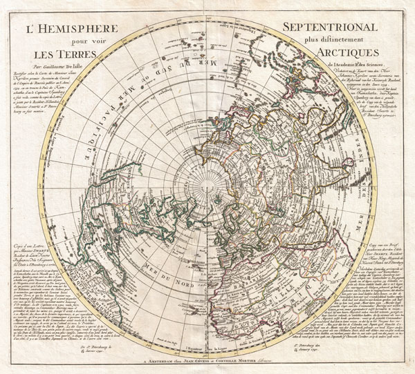
L'Hemisphere Septentrional pour voir pllus distinctement Les Terre Arctiques.
c. 1741 (dated 1739) 19 x 21 in (48.26 x 53.34 cm)
c. 1741 (dated 1739) 19 x 21 in (48.26 x 53.34 cm)
Description
This is a stunning and important map of the Northern Hemisphere originally drawn by Guillaume de L'Isle in 1714 and updated by Coven's and Mortier in 1741. Covers from the North Pole south in all directions to include the Arctic Regions, all of North American, Central America, Asia, and Europe with parts of South America and most of Africa. To either side of the map proper (in French on left side and in Dutch on right side) is a letter written by Monsieur Swartz, a Danish explorer in the service of the Tzar, regarding his c. 1734 - 1740 explorations near Japan and Kamchatka.
Covens and Mortier's most interesting updates over the De L'Isle version of this map relate to explorations in North America and in East Asia.
North America is drawn as it appeared at the height of the Colonial period. English colonies skirt the east coast, the French control the Great Lakes regions and Louisiana, and the Spanish dominate in Mexico, California and the Southwest. California is drawn connected to the mainland with a dotted line - indicating that European map publishers were not yet prepared to give up on the idea that California may indeed be an Island. Names the city of Quivara, which is one of the lands associated with Spanish legends of the Seven Cities of Gold. Also notes the Sioux and the Apalache peoples. As befits De L'Isle's scientific approach to cartographer much of the unexplored northwest of America remains blank.
By contrast the northeast parts of Asia, which had recently been explored by Vitus Bering and Tschirikow, offer a number of interesting elements. The land of Compagnie is shown just the east of Yedso (likely Hokkaido) with a note regarding its mysterious discovery by Jean de Gama. Often called de Gamma Land or Gama, this island was supposedly discovered in the 17th century by a mysterious figure known as Jean de Gama. Various subsequent navigators claim to have seen this land, but it was left to Bering to finally debunk the myth. In 1729, he sailed for three days looking for Juan de Gama land but never found it. Thought it may be little more than a mis-mapping of Hokkaido or the Japanese Kuriles, Gama or Compagnie remained on maps for about 50 years following Bering's voyages until the explorations of Cook confirmed the Bering findings.
Japan itself is only vaguely mapped though Edo (Yendo) is indicated. Just to the west the Peninsula of Korea is drawn with a fairly accurate if slightly bulbous form. Further south Formosa and the Philippines are well mapped.
Published by Covens and Mortier in their c. 1741 reissue of Guillaume de L'Isle's Atlas Nouveau...
CartographerS
Covens and Mortier (1721 - c. 1862) was an Amsterdam publishing firm, the successor to the extensive publishing empire built by Pierre Mortier (1661 - 1711). Covens and Mortier maps are often criticized as derivative - but this is not fully the case. Pierre Mortier lived in Paris from 1681 to 1685. There he established close relationships the the greatest French cartographers of the era, including De L'Isle and D'Anville. His business model was based upon leveraging Dutch printing technology and sophistication to co-publish state of the art French cartography. Upon Mortier's death in 1711 his firm was taken over by his son, Cornelius Mortier (1699 - 1783). Cornelius married the sister of Johannes Covens (1697 - 1774) in 1721 and, partnering with his brother in law, established the Covens and Mortier firm. Under the Covens and Mortier imprint, Cornelius and Johannes continued in Pierre's model of publishing the most up-to-date French works with permission. They quickly became one of the largest and most prolific Dutch publishing concerns of the 18th century. The firm and its successors published thousands of maps over a 120 year period from 1721 to the mid-1800s. During their long lifespan the Covens and Mortier firm published as Covens and Mortier (1721 - 1778), J. Covens and Son (1778 - 94) and Mortier, Covens and Son (1794 - c. 1862). More by this mapmaker...
The De L'Isle family (fl. c. 1700 - c. 1760) (also written Delisle) were, in composite, a mapmaking tour de force who redefined early 18th century European cartography. Claude De L'Isle (1644 -1720), the family patriarch, was Paris based a historian and geographer under Nicholas Sanson. De L'Isle and his sons were proponents of the school of "positive geography" and were definitive figures, defining the heights of the Golden Age of French Cartography. Of his twelve sons, four, Guillaume (1675 - 1726), Simon Claude (1675 - 1726), Joseph Nicholas (1688 - 1768) and Louis (1720 - 1745), made a significant contributions to cartography. Without a doubt Guillaume was the most remarkable member of the family. It is said that Guillaume's skill as a cartographer was so prodigious that he drew his first map at just nine years of age. He was tutored by J. D. Cassini in astronomy, science, mathematics and cartography. By applying these diverse disciplines to the vast stores of information provided by 18th century navigators, Guillaume created the technique that came to be known as "scientific cartography", essentially an extension of Sanson's "positive geography". This revolutionary approach transformed the field of cartography and created a more accurate picture of the world. Among Guillaume's many firsts are the first naming of Texas, the first correct map of the Mississippi, the final rejection of the insular California fallacy, and the first identification of the correct longitudes of America. Stylistically De L'Isle also initiated important changes to the medium, eschewing the flamboyant Dutch style of the previous century in favor of a highly detailed yet still decorative approach that yielded map both beautiful and informative. Guillaume was elected to the French Academie Royale des Sciences at 27. Later, in 1718, he was also appointed "Premier Geographe du Roi", an office created especially for him. De L'Isle personally financed the publication of most of his maps, hoping to make heavy royalties on their sales. Unfortunately he met an untimely death in 1728, leaving considerable debt and an impoverished child and widow. De L'Isle's publishing firm was taken over by his assistant, Phillipe Buache who became, posthumously, his son in law. The other De L'Isle brothers, Joseph Nicholas and Louis De L'Isle, were employed in the Service of Peter the Great of Russia as astronomers and surveyors. They are responsible for cataloguing and compiling the data obtained from Russian expeditions in the Pacific and along the northwest coast of America, including the seminal explorations of Vitus Bering and Aleksei Chirikov. The De L'Isles, like their rivals the Vaugondys , must be considered speculative geographers. Speculative geography was a genre of mapmaking that evolved in Europe, particularly Paris, in the middle to late 18th century. Cartographers in this genre would fill in unknown areas on their maps with speculations based upon their vast knowledge of cartography, personal geographical theories, and often dubious primary source material gathered by explorers and navigators. This approach, which attempted to use the known to validate the unknown, naturally engendered many rivalries. The era of speculatively cartography effectively ended with the late 18th century explorations of Captain Cook, Jean Francois de Galaup de La Perouse, and George Vancouver. Learn More...
Source
Covens, J. & Mortier, C., Atlas nouveau, contenant toutes les parties su Monde, ou sont exactement remarquees les empires, monarchies, royaumes, etats, republiques, &c. Par Guillaume de l'Isle, c. 1841 editon.
Condition
Very good condition. Original centerfold. Else clean.
References
Rumsey 4638.002. Wagner, H. R., The Cartography of the Northwest Coastof America to the Year 1800, #504.